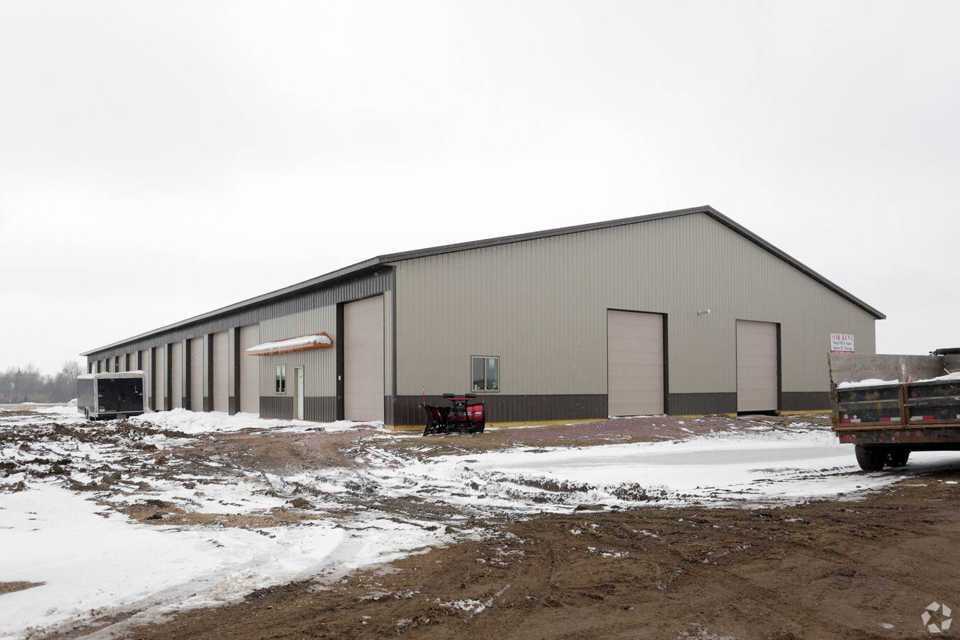
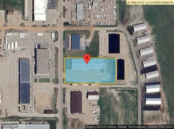
Property Record
27174 470Th Ave, Tea, SD 57064

NEARBY LISTINGS FOR SALE OR LEASE
Property Detail
27174 470Th Ave
Sioux Falls, SD
Landmark
100.50.30.H05A
LANDMARK INDUSTRIAL PARK ADD - TRACT 5A *EX LOT H-1* - 30-100-50 -
Commercialnec
Lincoln
X
South Dakota
46099C0625D
h-1
2023
2.99 AC
2023
Sioux Falls
010115
Other Market Areas
DEMOGRAPHICS near 27174 470Th Ave
1 Mile
3 Mile
5 Mile
2024 Total Population
731
18,613
64,639
2029 Population
905
22,698
75,443
Pop Growth 2024-2029
+ 23.80%
+ 21.95%
+ 16.71%
Average Age
33
34
37
2024 Total Households
243
6,642
25,711
HH Growth 2024-2029
+ 24.28%
+ 22.19%
+ 16.49%
Median Household Inc
$98,112
$89,658
$80,881
Avg Household Size
3.00
2.80
2.50
2024 Avg HH Vehicles
2.00
2.00
2.00
Median Home Value
$304,808
$277,939
$272,764
Median Year Built
2007
2007
2002
Nearby Places
- Restaurants
- Banks
- Shops
- Fitness
- Groceries
PUBLIC TRANSPORTATION
AIRPORT
Joe Foss Field
DRIVE
WALK
Distance
Joe Foss Field
31 min
13.2 mi
Freight Ports
Port Milwaukee
DRIVE
WALK
Distance
Port Milwaukee
558 min
512.7 mi
SALE & LEASE HISTORY
LISTING DATE
SALE/LEASE

May 19, 2020
For Lease
Jan 29, 2018
For Lease
Apr 16, 2018
For Lease
Nearby Properties
Address
Land Use
TOTAL SIZE
Lot Size
Zoning
Address
Land Use
TOTAL SIZE
Lot Size
Zoning
8.51 AC
MUNICIPALI
Address
Land Use
TOTAL SIZE
Lot Size
Zoning
9.57 AC
MUNICIPALI
Address
Land Use
TOTAL SIZE
Lot Size
Zoning
11.13 AC
MUNICIPALI
Address
Land Use
TOTAL SIZE
Lot Size
Zoning
6.51 AC
MUNICIPALI
Address
Land Use
TOTAL SIZE
Lot Size
Zoning
8.65 AC
MUNICIPALI
Address
Land Use
TOTAL SIZE
Lot Size
Zoning
5.12 AC
MUNICIPALI
Address
Land Use
TOTAL SIZE
Lot Size
Zoning
8.28 AC
MUNICIPALI
Address
Land Use
TOTAL SIZE
Lot Size
Zoning
11.80 AC
I-1 LIGHT
Address
Land Use
TOTAL SIZE
Lot Size
Zoning
4.25 AC
MUNICIPALI
Address
Land Use
TOTAL SIZE
Lot Size
Zoning
3.82 AC
MUNICIPALI
Address
Land Use
TOTAL SIZE
Lot Size
Zoning
4.53 AC
MUNICIPALI
Address
Land Use
TOTAL SIZE
Lot Size
Zoning
3.56 AC
MUNICIPALI
Address
Land Use
TOTAL SIZE
Lot Size
Zoning
2.47 AC
MUNICIPALI
Address
Land Use
TOTAL SIZE
Lot Size
Zoning
4.04 AC
C COMMERCI
Address
Land Use
TOTAL SIZE
Lot Size
Zoning
7 AC
I-1 LIGHT
Address
Land Use
TOTAL SIZE
Lot Size
Zoning
1.56 AC
MUNICIPALI
Address
Land Use
TOTAL SIZE
Lot Size
Zoning
2.50 AC
MUNICIPALI
Address
Land Use
TOTAL SIZE
Lot Size
Zoning
2.48 AC
MUNICIPALI
Address
Land Use
TOTAL SIZE
Lot Size
Zoning
2.68 AC
MUNICIPALI
Address
Land Use
TOTAL SIZE
Lot Size
Zoning
5.43 AC
MUNICIPALI
Address
Land Use
TOTAL SIZE
Lot Size
Zoning
2.94 AC
MUNICIPALI
Address
Land Use
TOTAL SIZE
Lot Size
Zoning
9.50 AC
MUNICIPALI
Address
Land Use
TOTAL SIZE
Lot Size
Zoning
7.60 AC
MUNICIPALI
Address
Land Use
TOTAL SIZE
Lot Size
Zoning
3.60 AC
I-1 LIGHT
Address
Land Use
TOTAL SIZE
Lot Size
Zoning
1.22 AC
MUNICIPALI
Address
Land Use
TOTAL SIZE
Lot Size
Zoning
2.28 AC
I-1 LIGHT
Address
Land Use
TOTAL SIZE
Lot Size
Zoning
2.23 AC
MUNICIPALI
Address
Land Use
TOTAL SIZE
Lot Size
Zoning
3.04 AC
I-1 LIGHT
Address
Land Use
TOTAL SIZE
Lot Size
Zoning
1.20 AC
MUNICIPALI
Address
Land Use
TOTAL SIZE
Lot Size
Zoning
14.59 AC
MUNICIPALI
The World's #1 Commercial Real Estate Marketplace
Connect with us
© 2025 CoStar Group
The information above has been obtained from sources believed reliable. While we do not doubt its accuracy we have not verified it and make no guarantee, warranty or representation about it. It is your responsibility to independently confirm its accuracy and completeness. Any projections, opinions, assumptions, or estimates used are for example only and do not represent the current or future performance of the property. The value of this transaction to you depends on tax and other factors which should be evaluated by your tax, financial, and legal advisors. You and your advisors should conduct a careful, independent investigation of the property to determine to your satisfaction the suitability of the property for your needs.