Property Record
272 River Rd, Claremont, NH 03743
NEARBY LISTINGS FOR SALE OR LEASE
-
-
View all Claremont listings for sale on LoopNet.com
Property Detail
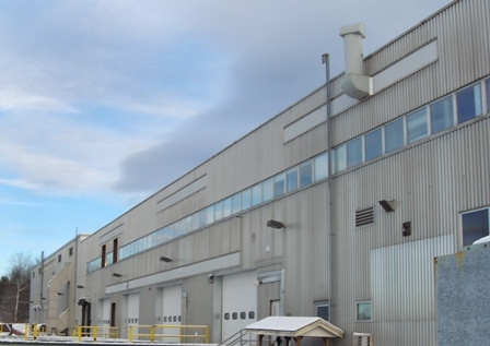
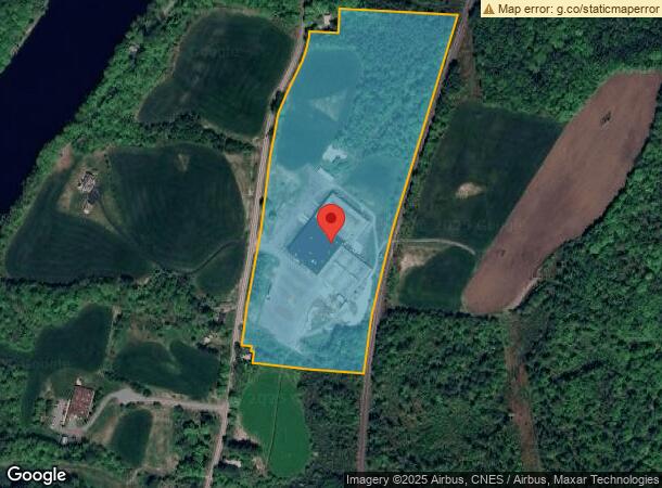
272 River Rd
Manufacturinglight
Sullivan
X
New Hampshire
50027C0732E
8
2023
29.50 AC
2023
Other Market Areas
975800
Claremont-Lebanon, NH-VT
248,192 SF
CLMN-000163-000000-000008
DEMOGRAPHICS near 272 River Rd
1 Mile
3 Mile
5 Mile
2024 Total Population
794
13,130
17,293
2029 Population
838
13,858
18,166
Pop Growth 2024-2029
+ 5.54%
+ 5.54%
+ 5.05%
Average Age
42
42
43
2024 Total Households
333
5,621
7,386
HH Growth 2024-2029
+ 5.11%
+ 5.28%
+ 4.75%
Median Household Inc
$54,186
$47,118
$48,956
Avg Household Size
2.30
2.20
2.20
2024 Avg HH Vehicles
2.00
2.00
2.00
Median Home Value
$156,115
$158,223
$161,633
Median Year Built
1960
1961
1965
Nearby Places
- Restaurants
- Banks
- Shops
- Fitness
- Groceries
PUBLIC TRANSPORTATION
COMMUTER RAIL
Claremont Amtrak (Vermonter - Amtrak)
DRIVE
WALK
Distance
Claremont Amtrak (Vermonter - Amtrak)
3 min
1.4 mi
Windsor-Mt. Ascutney Amtrak (Vermonter - Amtrak)
DRIVE
WALK
Distance
Windsor-Mt. Ascutney Amtrak (Vermonter - Amtrak)
16 min
9.8 mi
Freight Ports
Albany, NY Port
DRIVE
WALK
Distance
Albany, NY Port
171 min
109.4 mi
Nearby Properties
Address
Land Use
TOTAL SIZE
Lot Size
Zoning
Address
Land Use
TOTAL SIZE
Lot Size
Zoning
73,663 SF
19.48 AC
R1
Address
Land Use
TOTAL SIZE
Lot Size
Zoning
64,201 SF
3.18 AC
CR2
Address
Land Use
TOTAL SIZE
Lot Size
Zoning
124,339 SF
1.59 AC
MU
Address
Land Use
TOTAL SIZE
Lot Size
Zoning
246,345 SF
42.53 AC
I2
Address
Land Use
TOTAL SIZE
Lot Size
Zoning
14,980 SF
6.49 AC
R2
Address
Land Use
TOTAL SIZE
Lot Size
Zoning
3,304 SF
58 AC
I2
Address
Land Use
TOTAL SIZE
Lot Size
Zoning
24,477 SF
3.69 AC
CR2
Address
Land Use
TOTAL SIZE
Lot Size
Zoning
35,095 SF
3.03 AC
B2
Address
Land Use
TOTAL SIZE
Lot Size
Zoning
7,868 SF
5.43 AC
B2
Address
Land Use
TOTAL SIZE
Lot Size
Zoning
46,410 SF
2.56 AC
MU
Address
Land Use
TOTAL SIZE
Lot Size
Zoning
137,790 SF
25.28 AC
I1
Address
Land Use
TOTAL SIZE
Lot Size
Zoning
72,925 SF
27.69 AC
R2
Address
Land Use
TOTAL SIZE
Lot Size
Zoning
45,723 SF
3.49 AC
R1
Address
Land Use
TOTAL SIZE
Lot Size
Zoning
12,498 SF
4.18 AC
MU
Address
Land Use
TOTAL SIZE
Lot Size
Zoning
1,700 SF
130.86 AC
I1
Address
Land Use
TOTAL SIZE
Lot Size
Zoning
68,135 SF
1.61 AC
CR2
Address
Land Use
TOTAL SIZE
Lot Size
Zoning
24,236 SF
0.41 AC
MU
Address
Land Use
TOTAL SIZE
Lot Size
Zoning
8,482 SF
0.32 AC
MU
Address
Land Use
TOTAL SIZE
Lot Size
Zoning
95,377 SF
14.65 AC
I3
Address
Land Use
TOTAL SIZE
Lot Size
Zoning
84,192 SF
0.97 AC
MU
Address
Land Use
TOTAL SIZE
Lot Size
Zoning
5,841 SF
224.10 AC
AR
Address
Land Use
TOTAL SIZE
Lot Size
Zoning
28,444 SF
24.10 AC
B2
Address
Land Use
TOTAL SIZE
Lot Size
Zoning
32,396 SF
4.63 AC
CR1
Address
Land Use
TOTAL SIZE
Lot Size
Zoning
4,320 SF
37.49 AC
RR
Address
Land Use
TOTAL SIZE
Lot Size
Zoning
18,325 SF
13.23 AC
B2
Address
Land Use
TOTAL SIZE
Lot Size
Zoning
163,241 SF
16.07 AC
I1
Address
Land Use
TOTAL SIZE
Lot Size
Zoning
9,899 SF
1.40 AC
CR2
Address
Land Use
TOTAL SIZE
Lot Size
Zoning
86,164 SF
13.20 AC
I1
Address
Land Use
TOTAL SIZE
Lot Size
Zoning
108,564 SF
18.07 AC
I1
Address
Land Use
TOTAL SIZE
Lot Size
Zoning
13,326 SF
1.98 AC
PR
The World's #1 Commercial Real Estate Marketplace
Connect with us
© 2025 CoStar Group
The information above has been obtained from sources believed reliable. While we do not doubt its accuracy we have not verified it and make no guarantee, warranty or representation about it. It is your responsibility to independently confirm its accuracy and completeness. Any projections, opinions, assumptions, or estimates used are for example only and do not represent the current or future performance of the property. The value of this transaction to you depends on tax and other factors which should be evaluated by your tax, financial, and legal advisors. You and your advisors should conduct a careful, independent investigation of the property to determine to your satisfaction the suitability of the property for your needs.