Property Record
27278 Verhey Pl, Tea, SD 57064
NEARBY LISTINGS FOR SALE OR LEASE
Property Detail
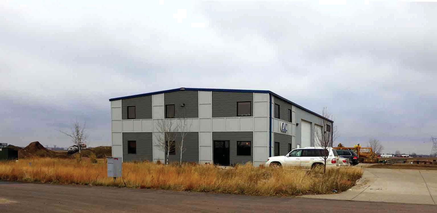
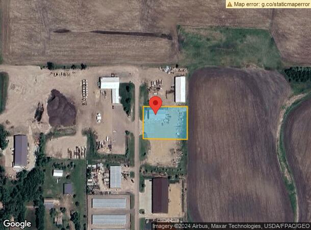
27278 Verhey Pl
Sioux Falls, SD
Verhey Addition
100.50.31.K005
VERHEY ADD - LOT 5 S1/2 GOV'T LOTS 1 & 2 - 31-100-50 -
Commercialnec
Lincoln
X
South Dakota
46099C0625D
5-2
2023
1.03 AC
2023
Sioux Falls
010115
Other Market Areas
DEMOGRAPHICS near 27278 Verhey Pl
1 Mile
3 Mile
5 Mile
2024 Total Population
421
10,945
46,736
2029 Population
513
13,440
55,837
Pop Growth 2024-2029
+ 21.85%
+ 22.80%
+ 19.47%
Average Age
38
34
36
2024 Total Households
144
3,822
17,522
HH Growth 2024-2029
+ 22.22%
+ 23.05%
+ 19.56%
Median Household Inc
$95,945
$87,143
$88,767
Avg Household Size
2.90
2.80
2.60
2024 Avg HH Vehicles
3.00
3.00
2.00
Median Home Value
$333,333
$275,520
$275,602
Median Year Built
1997
2006
2004
Nearby Places
- Restaurants
- Banks
- Shops
- Fitness
- Groceries
PUBLIC TRANSPORTATION
AIRPORT
Joe Foss Field
Drive
Walk
Distance
Joe Foss Field
31 min
14.5 mi
Freight Ports
Port Milwaukee
Drive
Walk
Distance
Port Milwaukee
558 min
514.0 mi
SALE & LEASE HISTORY
LISTING DATE
SALE/LEASE

Nov 13, 2020
For Sale
Nearby Properties
Address
Land Use
TOTAL SIZE
Lot Size
Zoning
Address
Land Use
TOTAL SIZE
Lot Size
Zoning
9.57 AC
MUNICIPALI
Address
Land Use
TOTAL SIZE
Lot Size
Zoning
8.65 AC
MUNICIPALI
Address
Land Use
TOTAL SIZE
Lot Size
Zoning
8.28 AC
MUNICIPALI
Address
Land Use
TOTAL SIZE
Lot Size
Zoning
11.80 AC
I-1 LIGHT
Address
Land Use
TOTAL SIZE
Lot Size
Zoning
3.82 AC
MUNICIPALI
Address
Land Use
TOTAL SIZE
Lot Size
Zoning
3.56 AC
MUNICIPALI
Address
Land Use
TOTAL SIZE
Lot Size
Zoning
2.47 AC
MUNICIPALI
Address
Land Use
TOTAL SIZE
Lot Size
Zoning
4.04 AC
C COMMERCI
Address
Land Use
TOTAL SIZE
Lot Size
Zoning
7 AC
I-1 LIGHT
Address
Land Use
TOTAL SIZE
Lot Size
Zoning
1.56 AC
MUNICIPALI
Address
Land Use
TOTAL SIZE
Lot Size
Zoning
2.50 AC
MUNICIPALI
Address
Land Use
TOTAL SIZE
Lot Size
Zoning
2.48 AC
MUNICIPALI
Address
Land Use
TOTAL SIZE
Lot Size
Zoning
9.50 AC
MUNICIPALI
Address
Land Use
TOTAL SIZE
Lot Size
Zoning
7.60 AC
MUNICIPALI
Address
Land Use
TOTAL SIZE
Lot Size
Zoning
3.60 AC
I-1 LIGHT
Address
Land Use
TOTAL SIZE
Lot Size
Zoning
2.28 AC
I-1 LIGHT
Address
Land Use
TOTAL SIZE
Lot Size
Zoning
3.04 AC
I-1 LIGHT
Address
Land Use
TOTAL SIZE
Lot Size
Zoning
14.59 AC
MUNICIPALI
Address
Land Use
TOTAL SIZE
Lot Size
Zoning
1.80 AC
MUNICIPALI
Address
Land Use
TOTAL SIZE
Lot Size
Zoning
4.72 AC
MUNICIPALI
Address
Land Use
TOTAL SIZE
Lot Size
Zoning
4.62 AC
MUNICIPALI
Address
Land Use
TOTAL SIZE
Lot Size
Zoning
2.34 AC
I-1 LIGHT
Address
Land Use
TOTAL SIZE
Lot Size
Zoning
2.02 AC
C COMMERCI
Address
Land Use
TOTAL SIZE
Lot Size
Zoning
1.19 AC
MUNICIPALI
Address
Land Use
TOTAL SIZE
Lot Size
Zoning
1.94 AC
C COMMERCI
Address
Land Use
TOTAL SIZE
Lot Size
Zoning
2 AC
C COMMERCI
Address
Land Use
TOTAL SIZE
Lot Size
Zoning
3.99 AC
C COMMERCI
Address
Land Use
TOTAL SIZE
Lot Size
Zoning
2.70 AC
I-1 LIGHT
Address
Land Use
TOTAL SIZE
Lot Size
Zoning
2.08 AC
I-1 LIGHT
Address
Land Use
TOTAL SIZE
Lot Size
Zoning
100.05 AC
A-1 AGRICU
Start a new search to find other properties for sale or lease
Connect with us
© 2024 CoStar Group
The information above has been obtained from sources believed reliable. While we do not doubt its accuracy we have not verified it and make no guarantee, warranty or representation about it. It is your responsibility to independently confirm its accuracy and completeness. Any projections, opinions, assumptions, or estimates used are for example only and do not represent the current or future performance of the property. The value of this transaction to you depends on tax and other factors which should be evaluated by your tax, financial, and legal advisors. You and your advisors should conduct a careful, independent investigation of the property to determine to your satisfaction the suitability of the property for your needs.