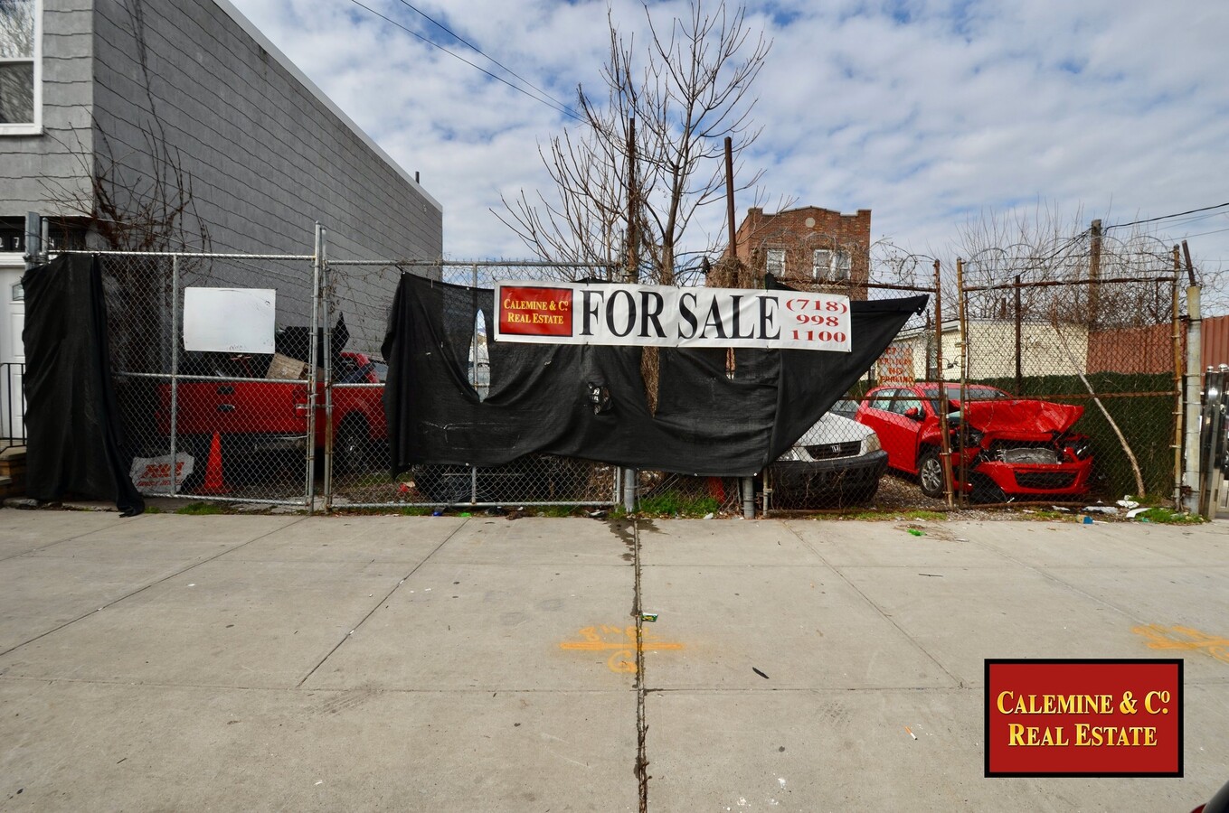
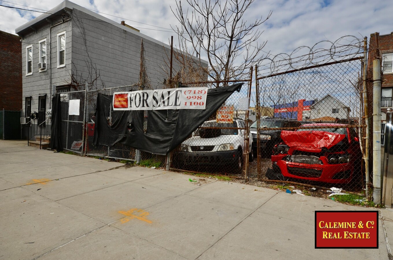
Property Record
15Th West St, Brooklyn, NY 11222
NEARBY LISTINGS FOR SALE OR LEASE
-
-
-
-
-
-
-
-
-
-
-
-
-
-
-
-
-
-
-
-
-
-
-
-
-
-
No Photo
-
View all Brooklyn listings for sale on LoopNet.com
Property Detail
15Th West St
New York-Jersey City-White Plains, NY-NJ
DOCID-2023060200141001
06996-0068
Kings
Commercialnec
New York
AE
68
3604970353F
0.06 AC
2024
South Brooklyn
2024
Long Island (New York)
057300
DEMOGRAPHICS near 15Th West St
1 Mile
3 Mile
5 Mile
2024 Total Population
81,410
484,004
1,123,258
2029 Population
77,342
451,234
1,044,304
Pop Growth 2024-2029
(5.00%)
(6.77%)
(7.03%)
Average Age
45
42
40
2024 Total Households
32,496
174,172
386,815
HH Growth 2024-2029
(5.37%)
(7.14%)
(7.32%)
Median Household Inc
$41,948
$58,234
$64,638
Avg Household Size
2.40
2.70
2.80
2024 Avg HH Vehicles
1.00
1.00
1.00
Median Home Value
$525,746
$779,633
$785,049
Median Year Built
1963
1949
1948
Nearby Places
- Restaurants
- Banks
- Shops
- Fitness
- Groceries
PUBLIC TRANSPORTATION
TRANSIT/SUBWAY
Nassau Avenue (G - New York MTA Subway (The Subway))
DRIVE
WALK
Distance
Nassau Avenue (G - New York MTA Subway (The Subway))
1 min
6 min
0.3 mi
Greenpoint Avenue (G - New York MTA Subway (The Subway))
DRIVE
WALK
Distance
Greenpoint Avenue (G - New York MTA Subway (The Subway))
2 min
7 min
0.4 mi
Bedford Avenue (L - New York MTA Subway (The Subway))
DRIVE
WALK
Distance
Bedford Avenue (L - New York MTA Subway (The Subway))
3 min
18 min
1.0 mi
Graham Avenue (L - New York MTA Subway (The Subway))
DRIVE
WALK
Distance
Graham Avenue (L - New York MTA Subway (The Subway))
3 min
19 min
1.0 mi
Lorimer Street (L Line) (L - New York MTA Subway (The Subway))
DRIVE
WALK
Distance
Lorimer Street (L Line) (L - New York MTA Subway (The Subway))
3 min
20 min
1.1 mi
COMMUTER RAIL
Hunterspoint Avenue Station (Hempstead Branch - Long Island Rail Road, Oyster Bay Branch - Long Island Rail Road)
DRIVE
WALK
Distance
Hunterspoint Avenue Station (Hempstead Branch - Long Island Rail Road, Oyster Bay Branch - Long Island Rail Road)
5 min
1.6 mi
Long Island City Station (Hempstead Branch - Long Island Rail Road)
DRIVE
WALK
Distance
Long Island City Station (Hempstead Branch - Long Island Rail Road)
6 min
1.9 mi
AIRPORT
Laguardia
DRIVE
WALK
Distance
Laguardia
14 min
6.9 mi
John F Kennedy International
DRIVE
WALK
Distance
John F Kennedy International
24 min
15.0 mi
Newark Liberty International
DRIVE
WALK
Distance
Newark Liberty International
28 min
16.0 mi
Freight Ports
NY - Red Hook Container Terminal
DRIVE
WALK
Distance
NY - Red Hook Container Terminal
11 min
5.8 mi
SALE & LEASE HISTORY
LISTING DATE
SALE/LEASE

Oct 21, 2022
For Sale
Nearby Properties
Address
Land Use
TOTAL SIZE
Lot Size
Zoning
Address
Land Use
TOTAL SIZE
Lot Size
Zoning
1,783,434 SF
1.94 AC
C5-3
Address
Land Use
TOTAL SIZE
Lot Size
Zoning
2,245,112 SF
2.02 AC
C6-6
Address
Land Use
TOTAL SIZE
Lot Size
Zoning
2,161,994 SF
3.79 AC
M1-5
Address
Land Use
TOTAL SIZE
Lot Size
Zoning
2,636,182 SF
2.35 AC
C65.5
Address
Land Use
TOTAL SIZE
Lot Size
Zoning
1,678,135 SF
1.01 AC
C5-3
Address
Land Use
TOTAL SIZE
Lot Size
Zoning
2,734,038 SF
4.24 AC
C52.5
Address
Land Use
TOTAL SIZE
Lot Size
Zoning
1,897,491 SF
2.06 AC
C52.5
Address
Land Use
TOTAL SIZE
Lot Size
Zoning
1,638,259 SF
1.42 AC
C52.5
Address
Land Use
TOTAL SIZE
Lot Size
Zoning
2,812,739 SF
2.10 AC
C5-3
Address
Land Use
TOTAL SIZE
Lot Size
Zoning
1,586,876 SF
1.87 AC
C5-3
Address
Land Use
TOTAL SIZE
Lot Size
Zoning
1,048,620 SF
5.67 AC
C6-4
Address
Land Use
TOTAL SIZE
Lot Size
Zoning
1,962,900 SF
1.89 AC
C66.5
Address
Land Use
TOTAL SIZE
Lot Size
Zoning
1,842,991 SF
2.08 AC
C66.5
Address
Land Use
TOTAL SIZE
Lot Size
Zoning
2,535,958 SF
2.94 AC
C6-4
Address
Land Use
TOTAL SIZE
Lot Size
Zoning
1,642,675 SF
1.05 AC
C6-7
Address
Land Use
TOTAL SIZE
Lot Size
Zoning
1,606,528 SF
1.84 AC
C6-6
Address
Land Use
TOTAL SIZE
Lot Size
Zoning
1,649,604 SF
1.51 AC
C67T
Address
Land Use
TOTAL SIZE
Lot Size
Zoning
1,448,897 SF
1.56 AC
C6-6
Address
Land Use
TOTAL SIZE
Lot Size
Zoning
2,400,000 SF
15.14 AC
C5-2
Address
Land Use
TOTAL SIZE
Lot Size
Zoning
1,482,208 SF
1.71 AC
C5-3
Address
Land Use
TOTAL SIZE
Lot Size
Zoning
2,124,441 SF
17.29 AC
R8
Address
Land Use
TOTAL SIZE
Lot Size
Zoning
1,169,666 SF
1.42 AC
C52.5
Address
Land Use
TOTAL SIZE
Lot Size
Zoning
1,160,500 SF
1.62 AC
C6-6
Address
Land Use
TOTAL SIZE
Lot Size
Zoning
2,344,406 SF
1.84 AC
C5-3
Address
Land Use
TOTAL SIZE
Lot Size
Zoning
1,015,287 SF
1 AC
C5-3
Address
Land Use
TOTAL SIZE
Lot Size
Zoning
2,230,742 SF
6.33 AC
R9
Address
Land Use
TOTAL SIZE
Lot Size
Zoning
554,180 SF
0.60 AC
C6-6
Address
Land Use
TOTAL SIZE
Lot Size
Zoning
1,134,017 SF
1.05 AC
C5-3
Address
Land Use
TOTAL SIZE
Lot Size
Zoning
1,242,587 SF
1.49 AC
C6-6
Address
Land Use
TOTAL SIZE
Lot Size
Zoning
822,014 SF
1.38 AC
C52.5
The World's #1 Commercial Real Estate Marketplace
Connect with us
© 2025 CoStar Group
The information above has been obtained from sources believed reliable. While we do not doubt its accuracy we have not verified it and make no guarantee, warranty or representation about it. It is your responsibility to independently confirm its accuracy and completeness. Any projections, opinions, assumptions, or estimates used are for example only and do not represent the current or future performance of the property. The value of this transaction to you depends on tax and other factors which should be evaluated by your tax, financial, and legal advisors. You and your advisors should conduct a careful, independent investigation of the property to determine to your satisfaction the suitability of the property for your needs.