Property Record
2730 W Main St, Jefferson City, MO 65109
NEARBY LISTINGS FOR SALE OR LEASE
-
-
View all Jefferson City listings for sale on LoopNet.com
Property Detail
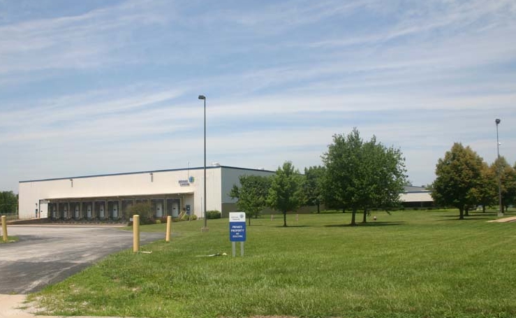
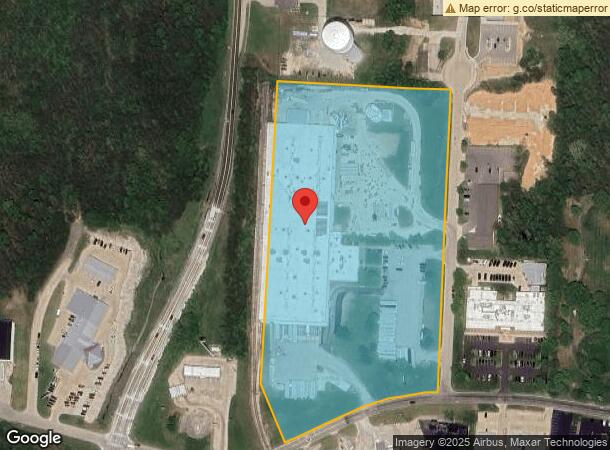
2730 W Main St
05-0.8-34-000-400-000-2001
PT NE SEC 3 PT W 1/2 SE FR NE COR W 1/2 SE S 1717.78 W 360 POB S 903.4 TO N LINE W MAIN SW 493.19 NW 180.51 N 908.59 E 536.83
Industrialgeneral
Cole
X
Missouri
29051C0126E
12.30 AC
2023
Other Market Areas
2024
Jefferson City, MO
010901
DEMOGRAPHICS near 2730 W Main St
1 Mile
3 Mile
5 Mile
2024 Total Population
4,569
23,532
50,873
2029 Population
4,462
23,089
50,122
Pop Growth 2024-2029
(2.34%)
(1.88%)
(1.48%)
Average Age
44
42
40
2024 Total Households
1,859
10,448
21,584
HH Growth 2024-2029
(2.64%)
(2.07%)
(1.60%)
Median Household Inc
$70,240
$58,793
$57,234
Avg Household Size
2.30
2.20
2.20
2024 Avg HH Vehicles
2.00
2.00
2.00
Median Home Value
$178,571
$187,092
$176,482
Median Year Built
1967
1977
1978
Nearby Places
- Restaurants
- Banks
- Shops
- Fitness
- Groceries
PUBLIC TRANSPORTATION
COMMUTER RAIL
Jefferson City Amtrak Station (Lincoln Service Missouri River Runner - Amtrak, Missouri River Runner - Amtrak)
DRIVE
WALK
Distance
Jefferson City Amtrak Station (Lincoln Service Missouri River Runner - Amtrak, Missouri River Runner - Amtrak)
7 min
3.7 mi
AIRPORT
Columbia Regional
DRIVE
WALK
Distance
Columbia Regional
30 min
23.4 mi
Freight Ports
Tulsa Port of Inola
DRIVE
WALK
Distance
Tulsa Port of Inola
346 min
306.7 mi
Nearby Properties
Address
Land Use
TOTAL SIZE
Lot Size
Zoning
Address
Land Use
TOTAL SIZE
Lot Size
Zoning
7.07 AC
C1
Address
Land Use
TOTAL SIZE
Lot Size
Zoning
59.73 AC
M2
Address
Land Use
TOTAL SIZE
Lot Size
Zoning
14.92 AC
PUD
Address
Land Use
TOTAL SIZE
Lot Size
Zoning
39.72 AC
M2
Address
Land Use
TOTAL SIZE
Lot Size
Zoning
4.25 AC
PUD
Address
Land Use
TOTAL SIZE
Lot Size
Zoning
13.23 AC
C2
Address
Land Use
TOTAL SIZE
Lot Size
Zoning
30.57 AC
C2
Address
Land Use
TOTAL SIZE
Lot Size
Zoning
4.68 AC
C1
Address
Land Use
TOTAL SIZE
Lot Size
Zoning
18.43 AC
C2
Address
Land Use
TOTAL SIZE
Lot Size
Zoning
3.88 AC
PUD
Address
Land Use
TOTAL SIZE
Lot Size
Zoning
Address
Land Use
TOTAL SIZE
Lot Size
Zoning
1.82 AC
M2
Address
Land Use
TOTAL SIZE
Lot Size
Zoning
Address
Land Use
TOTAL SIZE
Lot Size
Zoning
24.55 AC
C2
Address
Land Use
TOTAL SIZE
Lot Size
Zoning
2.84 AC
M1
Address
Land Use
TOTAL SIZE
Lot Size
Zoning
11.52 AC
PUD
Address
Land Use
TOTAL SIZE
Lot Size
Zoning
20.46 AC
PUD
Address
Land Use
TOTAL SIZE
Lot Size
Zoning
0.94 AC
C1
Address
Land Use
TOTAL SIZE
Lot Size
Zoning
13.32 AC
C2
Address
Land Use
TOTAL SIZE
Lot Size
Zoning
6.45 AC
C2
Address
Land Use
TOTAL SIZE
Lot Size
Zoning
7.02 AC
C2
Address
Land Use
TOTAL SIZE
Lot Size
Zoning
23.97 AC
C1
Address
Land Use
TOTAL SIZE
Lot Size
Zoning
4.76 AC
RS1
Address
Land Use
TOTAL SIZE
Lot Size
Zoning
9.42 AC
C2
Address
Land Use
TOTAL SIZE
Lot Size
Zoning
Address
Land Use
TOTAL SIZE
Lot Size
Zoning
Address
Land Use
TOTAL SIZE
Lot Size
Zoning
9.21 AC
CO
Address
Land Use
TOTAL SIZE
Lot Size
Zoning
8.11 AC
C1
Address
Land Use
TOTAL SIZE
Lot Size
Zoning
Address
Land Use
TOTAL SIZE
Lot Size
Zoning
3.36 AC
C1
The World's #1 Commercial Real Estate Marketplace
Connect with us
© 2025 CoStar Group
The information above has been obtained from sources believed reliable. While we do not doubt its accuracy we have not verified it and make no guarantee, warranty or representation about it. It is your responsibility to independently confirm its accuracy and completeness. Any projections, opinions, assumptions, or estimates used are for example only and do not represent the current or future performance of the property. The value of this transaction to you depends on tax and other factors which should be evaluated by your tax, financial, and legal advisors. You and your advisors should conduct a careful, independent investigation of the property to determine to your satisfaction the suitability of the property for your needs.