Property Record
2775 Foust Rd, Brownsville, TX 78521
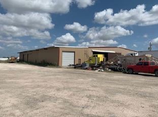
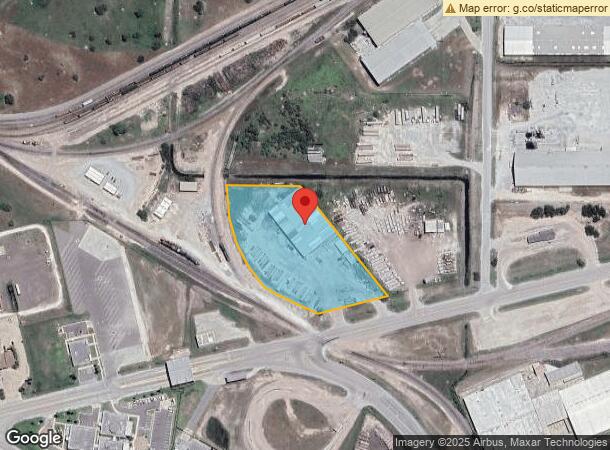
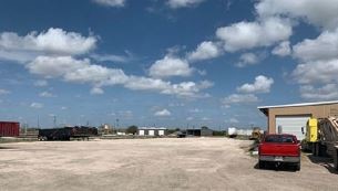
This Property Is For Sale
NEARBY LISTINGS FOR SALE OR LEASE
Property Detail
2775 Foust Rd
747540-4130-002201
El Jardin Resubdivision
Commercialnec
BLK 413 EL JARDIN RESUBDIVISION CONTRACT #4598 (BLDG ON LEASED LAND)
X
Cameron
48061C0585F
Texas
2023
3.50 AC
2024
Outlying Cameron County
014202
Brownsville/Harlingen
26,720 SF
Brownsville-Harlingen, TX
DEMOGRAPHICS near 2775 Foust Rd
1 Mile
3 Mile
5 Mile
2024 Total Population
4,265
31,763
93,941
2029 Population
4,341
32,932
96,562
Pop Growth 2024-2029
+ 1.78%
+ 3.68%
+ 2.79%
Average Age
32
33
35
2024 Total Households
1,052
8,966
28,045
HH Growth 2024-2029
+ 1.71%
+ 3.75%
+ 2.88%
Median Household Inc
$46,593
$39,838
$41,723
Avg Household Size
3.80
3.50
3.30
2024 Avg HH Vehicles
2.00
2.00
2.00
Median Home Value
$79,629
$79,366
$88,731
Median Year Built
1998
1998
1996
Nearby Places
- Restaurants
- Banks
- Shops
- Fitness
- Groceries
PUBLIC TRANSPORTATION
AIRPORT
Brownsville/South Padre Island International
DRIVE
WALK
Distance
Brownsville/South Padre Island International
9 min
4.7 mi
Valley International
DRIVE
WALK
Distance
Valley International
36 min
28.1 mi
Freight Ports
Port of Brownsville
DRIVE
WALK
Distance
Port of Brownsville
0 min
0.4 mi
Nearby Properties
Address
Land Use
TOTAL SIZE
Lot Size
Zoning
Address
Land Use
TOTAL SIZE
Lot Size
Zoning
167,737 SF
29.87 AC
Address
Land Use
TOTAL SIZE
Lot Size
Zoning
286,243 SF
19.21 AC
C
Address
Land Use
TOTAL SIZE
Lot Size
Zoning
145,240 SF
17.49 AC
Address
Land Use
TOTAL SIZE
Lot Size
Zoning
115,463 SF
22.09 AC
Address
Land Use
TOTAL SIZE
Lot Size
Zoning
120,166 SF
12.32 AC
Address
Land Use
TOTAL SIZE
Lot Size
Zoning
98,740 SF
15.56 AC
Address
Land Use
TOTAL SIZE
Lot Size
Zoning
88,256 SF
18.16 AC
Address
Land Use
TOTAL SIZE
Lot Size
Zoning
238,221 SF
27.02 AC
Address
Land Use
TOTAL SIZE
Lot Size
Zoning
137,228 SF
18.43 AC
A-U
Address
Land Use
TOTAL SIZE
Lot Size
Zoning
102,440 SF
22.88 AC
Address
Land Use
TOTAL SIZE
Lot Size
Zoning
48,760 SF
7 AC
C
Address
Land Use
TOTAL SIZE
Lot Size
Zoning
101,581 SF
4.14 AC
Address
Land Use
TOTAL SIZE
Lot Size
Zoning
64,545 SF
4.42 AC
Address
Land Use
TOTAL SIZE
Lot Size
Zoning
111,736 SF
13.59 AC
Address
Land Use
TOTAL SIZE
Lot Size
Zoning
23,154 SF
2.40 AC
C
Address
Land Use
TOTAL SIZE
Lot Size
Zoning
8,527 SF
13.02 AC
Address
Land Use
TOTAL SIZE
Lot Size
Zoning
107,200 SF
8.53 AC
C
Address
Land Use
TOTAL SIZE
Lot Size
Zoning
102,432 SF
5.27 AC
C
Address
Land Use
TOTAL SIZE
Lot Size
Zoning
101,189 SF
10 AC
C
Address
Land Use
TOTAL SIZE
Lot Size
Zoning
101,674 SF
8.14 AC
C
Address
Land Use
TOTAL SIZE
Lot Size
Zoning
104,000 SF
15.12 AC
I
Address
Land Use
TOTAL SIZE
Lot Size
Zoning
100,000 SF
7.79 AC
I
Address
Land Use
TOTAL SIZE
Lot Size
Zoning
100,000 SF
7.93 AC
I
Address
Land Use
TOTAL SIZE
Lot Size
Zoning
100,000 SF
5.20 AC
I
Address
Land Use
TOTAL SIZE
Lot Size
Zoning
56,600 SF
5.30 AC
C
Address
Land Use
TOTAL SIZE
Lot Size
Zoning
210,741 SF
20.06 AC
Address
Land Use
TOTAL SIZE
Lot Size
Zoning
5,620 SF
10.03 AC
Address
Land Use
TOTAL SIZE
Lot Size
Zoning
100,000 SF
11.34 AC
I
Address
Land Use
TOTAL SIZE
Lot Size
Zoning
88,220 SF
11 AC
C
Address
Land Use
TOTAL SIZE
Lot Size
Zoning
41,636 SF
10.01 AC
The World's #1 Commercial Real Estate Marketplace
Connect with us
© 2025 CoStar Group
The information above has been obtained from sources believed reliable. While we do not doubt its accuracy we have not verified it and make no guarantee, warranty or representation about it. It is your responsibility to independently confirm its accuracy and completeness. Any projections, opinions, assumptions, or estimates used are for example only and do not represent the current or future performance of the property. The value of this transaction to you depends on tax and other factors which should be evaluated by your tax, financial, and legal advisors. You and your advisors should conduct a careful, independent investigation of the property to determine to your satisfaction the suitability of the property for your needs.