Property Record
280 Durham Lake Rd, Dudley, NC 28333
NEARBY LISTINGS FOR SALE OR LEASE
-
-
View all Dudley listings for sale on LoopNet.com
Property Detail
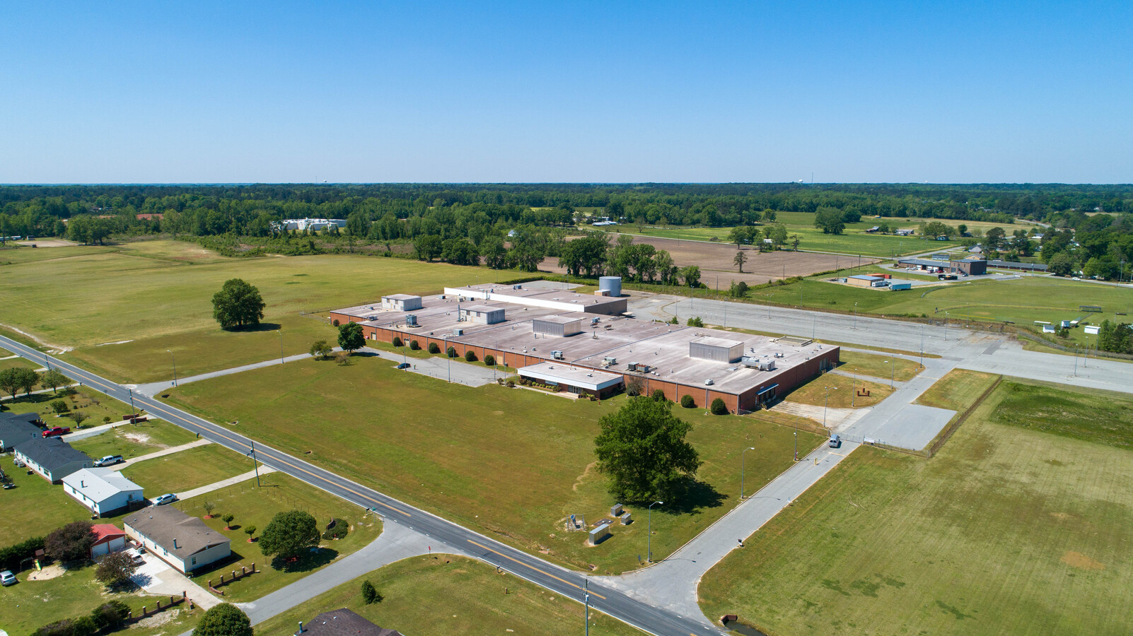
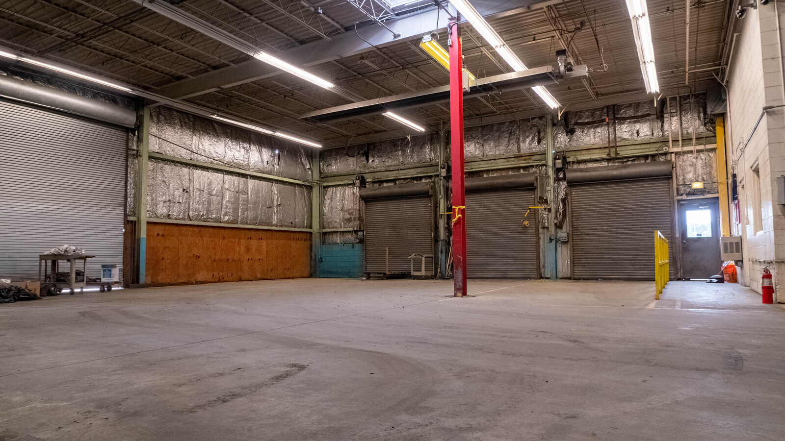
280 Durham Lake Rd
Goldsboro, NC
Woodland
2587582179
Wayne
Lightindustrial
North Carolina
X
27.28 AC
3720258700K
North Carolina Southeast Area
104,073 SF
Other Market Areas
DEMOGRAPHICS near 280 Durham Lake Rd
1 Mile
3 Mile
5 Mile
2024 Total Population
2,170
9,052
29,245
2029 Population
2,167
9,098
29,675
Pop Growth 2024-2029
(0.14%)
+ 0.51%
+ 1.47%
Average Age
39
39
39
2024 Total Households
868
3,498
11,223
HH Growth 2024-2029
(0.23%)
+ 0.49%
+ 1.60%
Median Household Inc
$46,198
$39,738
$36,522
Avg Household Size
2.40
2.50
2.40
2024 Avg HH Vehicles
2.00
2.00
2.00
Median Home Value
$143,932
$112,766
$108,918
Median Year Built
1985
1985
1975
Nearby Places
- Restaurants
- Banks
- Shops
- Fitness
- Groceries
SALE & LEASE HISTORY
LISTING DATE
SALE/LEASE

Jan 10, 2020
For Lease
Feb 07, 2020
For Sale
Aug 02, 2019
For Sale
Nearby Properties
Address
Land Use
TOTAL SIZE
Lot Size
Zoning
Address
Land Use
TOTAL SIZE
Lot Size
Zoning
3,624 SF
192.73 AC
HI
Address
Land Use
TOTAL SIZE
Lot Size
Zoning
28,800 SF
93.89 AC
Address
Land Use
TOTAL SIZE
Lot Size
Zoning
60,882 SF
9.13 AC
Address
Land Use
TOTAL SIZE
Lot Size
Zoning
126,249 SF
127.80 AC
LI
Address
Land Use
TOTAL SIZE
Lot Size
Zoning
57,496 SF
26.65 AC
OH
Address
Land Use
TOTAL SIZE
Lot Size
Zoning
118,416 SF
25 AC
I-5
Address
Land Use
TOTAL SIZE
Lot Size
Zoning
50,397 SF
6.52 AC
LI
Address
Land Use
TOTAL SIZE
Lot Size
Zoning
5,100 SF
2.69 AC
CS
Address
Land Use
TOTAL SIZE
Lot Size
Zoning
12,375 SF
3.73 AC
CS
Address
Land Use
TOTAL SIZE
Lot Size
Zoning
6,172 SF
3.99 AC
GB
Address
Land Use
TOTAL SIZE
Lot Size
Zoning
80,232 SF
32.98 AC
I-5
Address
Land Use
TOTAL SIZE
Lot Size
Zoning
38,742 SF
14.20 AC
GB
Address
Land Use
TOTAL SIZE
Lot Size
Zoning
4,156 SF
13.41 AC
OH
Address
Land Use
TOTAL SIZE
Lot Size
Zoning
4,308 SF
108.25 AC
LI
Address
Land Use
TOTAL SIZE
Lot Size
Zoning
1,842 SF
7.38 AC
R10
Address
Land Use
TOTAL SIZE
Lot Size
Zoning
18,796 SF
1.90 AC
Address
Land Use
TOTAL SIZE
Lot Size
Zoning
5,278 SF
1.37 AC
Address
Land Use
TOTAL SIZE
Lot Size
Zoning
9,432 SF
1.43 AC
Address
Land Use
TOTAL SIZE
Lot Size
Zoning
5,331 SF
1.68 AC
Address
Land Use
TOTAL SIZE
Lot Size
Zoning
22,813 SF
7.30 AC
Address
Land Use
TOTAL SIZE
Lot Size
Zoning
73,299 SF
7.73 AC
I-5
Address
Land Use
TOTAL SIZE
Lot Size
Zoning
19,678 SF
8.70 AC
Address
Land Use
TOTAL SIZE
Lot Size
Zoning
3,040 SF
1.62 AC
Address
Land Use
TOTAL SIZE
Lot Size
Zoning
4,182 SF
0.96 AC
Address
Land Use
TOTAL SIZE
Lot Size
Zoning
5,400 SF
35.66 AC
LI
Address
Land Use
TOTAL SIZE
Lot Size
Zoning
2,637 SF
1.95 AC
CS
Address
Land Use
TOTAL SIZE
Lot Size
Zoning
14,856 SF
14.24 AC
I-5
Address
Land Use
TOTAL SIZE
Lot Size
Zoning
3,731 SF
1.37 AC
LI
Address
Land Use
TOTAL SIZE
Lot Size
Zoning
16,682 SF
2.09 AC
GB
The World's #1 Commercial Real Estate Marketplace
Connect with us
© 2025 CoStar Group
The information above has been obtained from sources believed reliable. While we do not doubt its accuracy we have not verified it and make no guarantee, warranty or representation about it. It is your responsibility to independently confirm its accuracy and completeness. Any projections, opinions, assumptions, or estimates used are for example only and do not represent the current or future performance of the property. The value of this transaction to you depends on tax and other factors which should be evaluated by your tax, financial, and legal advisors. You and your advisors should conduct a careful, independent investigation of the property to determine to your satisfaction the suitability of the property for your needs.