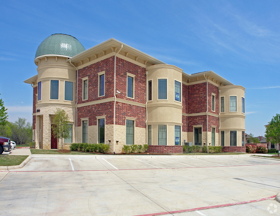
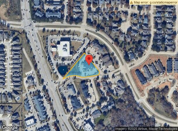
Property Record
2800 Corporate Cir, Flower Mound, TX 75028

Current Lease Availabilities
NEARBY LISTINGS FOR SALE OR LEASE
Property Detail
2800 Corporate Cir
Dallas-Fort Worth-Arlington, TX
Corporate Circle Addn
R248868
CORPORATE CIRCLE ADDN BLK A LOT 4
Commercialnec
Denton
X
Texas
48121C0540G
4
2024
1.26 AC
2024
Lewisville
021759
Dallas/Ft Worth
8,944 SF
DEMOGRAPHICS near 2800 Corporate Cir
1 Mile
3 Mile
5 Mile
2024 Total Population
11,289
98,016
190,558
2029 Population
13,608
117,169
228,406
Pop Growth 2024-2029
+ 20.54%
+ 19.54%
+ 19.86%
Average Age
41
41
40
2024 Total Households
4,134
34,059
65,718
HH Growth 2024-2029
+ 21.02%
+ 20.07%
+ 20.37%
Median Household Inc
$136,580
$131,763
$116,599
Avg Household Size
2.70
2.80
2.80
2024 Avg HH Vehicles
2.00
2.00
2.00
Median Home Value
$410,956
$395,237
$387,332
Median Year Built
1996
1994
1994
Nearby Places
- Restaurants
- Banks
- Shops
- Fitness
- Groceries
PUBLIC TRANSPORTATION
COMMUTER RAIL
Highland Village/Lewisville Lake Station (A-train - Denton County Transportation Authority)
DRIVE
WALK
Distance
Highland Village/Lewisville Lake Station (A-train - Denton County Transportation Authority)
11 min
5.4 mi
Old Town Station (A-train - Denton County Transportation Authority)
DRIVE
WALK
Distance
Old Town Station (A-train - Denton County Transportation Authority)
12 min
5.9 mi
AIRPORT
Dallas-Fort Worth International
DRIVE
WALK
Distance
Dallas-Fort Worth International
20 min
12.7 mi
Dallas Love Field
DRIVE
WALK
Distance
Dallas Love Field
37 min
25.4 mi
Freight Ports
Port of Shreveport
DRIVE
WALK
Distance
Port of Shreveport
244 min
222.9 mi
Nearby Properties
Address
Land Use
TOTAL SIZE
Lot Size
Zoning
Address
Land Use
TOTAL SIZE
Lot Size
Zoning
397,866 SF
43.19 AC
Address
Land Use
TOTAL SIZE
Lot Size
Zoning
319,086 SF
9.57 AC
Address
Land Use
TOTAL SIZE
Lot Size
Zoning
290,368 SF
9 AC
Address
Land Use
TOTAL SIZE
Lot Size
Zoning
231,049 SF
11.89 AC
Address
Land Use
TOTAL SIZE
Lot Size
Zoning
346,268 SF
18.06 AC
6
Address
Land Use
TOTAL SIZE
Lot Size
Zoning
237,073 SF
5.62 AC
Address
Land Use
TOTAL SIZE
Lot Size
Zoning
305,783 SF
15.50 AC
7G
Address
Land Use
TOTAL SIZE
Lot Size
Zoning
216,554 SF
13 AC
6B
Address
Land Use
TOTAL SIZE
Lot Size
Zoning
262,035 SF
10.88 AC
Address
Land Use
TOTAL SIZE
Lot Size
Zoning
244,838 SF
13.02 AC
Address
Land Use
TOTAL SIZE
Lot Size
Zoning
199,049 SF
28.96 AC
Address
Land Use
TOTAL SIZE
Lot Size
Zoning
228,040 SF
12.79 AC
6B
Address
Land Use
TOTAL SIZE
Lot Size
Zoning
240,889 SF
6.65 AC
Address
Land Use
TOTAL SIZE
Lot Size
Zoning
211,684 SF
11.23 AC
6G
Address
Land Use
TOTAL SIZE
Lot Size
Zoning
190,870 SF
7.66 AC
6G
Address
Land Use
TOTAL SIZE
Lot Size
Zoning
145,758 SF
17.25 AC
Address
Land Use
TOTAL SIZE
Lot Size
Zoning
135,394 SF
14.48 AC
Address
Land Use
TOTAL SIZE
Lot Size
Zoning
148,458 SF
14.69 AC
Address
Land Use
TOTAL SIZE
Lot Size
Zoning
155,604 SF
15.12 AC
7G
Address
Land Use
TOTAL SIZE
Lot Size
Zoning
168,897 SF
11.62 AC
7G
Address
Land Use
TOTAL SIZE
Lot Size
Zoning
169,188 SF
10.17 AC
Address
Land Use
TOTAL SIZE
Lot Size
Zoning
166,437 SF
4.38 AC
Address
Land Use
TOTAL SIZE
Lot Size
Zoning
89,332 SF
11.57 AC
Address
Land Use
TOTAL SIZE
Lot Size
Zoning
Address
Land Use
TOTAL SIZE
Lot Size
Zoning
141,189 SF
7.32 AC
6A
Address
Land Use
TOTAL SIZE
Lot Size
Zoning
85,916 SF
1.02 AC
Address
Land Use
TOTAL SIZE
Lot Size
Zoning
116,380 SF
14.14 AC
Address
Land Use
TOTAL SIZE
Lot Size
Zoning
95,492 SF
1.57 AC
Address
Land Use
TOTAL SIZE
Lot Size
Zoning
221,500 SF
22.73 AC
Address
Land Use
TOTAL SIZE
Lot Size
Zoning
70,106 SF
19.94 AC
The World's #1 Commercial Real Estate Marketplace
Connect with us
© 2025 CoStar Group
The information above has been obtained from sources believed reliable. While we do not doubt its accuracy we have not verified it and make no guarantee, warranty or representation about it. It is your responsibility to independently confirm its accuracy and completeness. Any projections, opinions, assumptions, or estimates used are for example only and do not represent the current or future performance of the property. The value of this transaction to you depends on tax and other factors which should be evaluated by your tax, financial, and legal advisors. You and your advisors should conduct a careful, independent investigation of the property to determine to your satisfaction the suitability of the property for your needs.