Property Record
2800 E 9Th Ave, Winfield, KS 67156
NEARBY LISTINGS FOR SALE OR LEASE
Property Detail
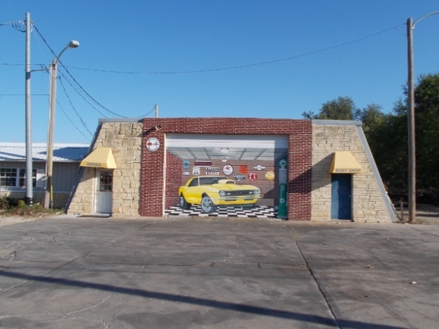
2800 E 9Th Ave
176-23-0-30-01-011.00-0
E1/2Sw4sec23twp32r4e
Warehouse
S23, T32, R04, ACRES 1.03, PT SW1/4 BEG W949.92 & N64.1 F ROM SE COR,W224.48,N200,E224.4 8,S TO POB
X
Cowley
20035C0352D
Kansas
2023
1.03 AC
2024
Kansas Area
493500
Other Market Areas
3,672 SF
Arkansas City-Winfield, KS
DEMOGRAPHICS near 2800 E 9Th Ave
1 Mile
3 Mile
5 Mile
2024 Total Population
3,768
11,426
13,138
2029 Population
3,761
11,376
13,056
Pop Growth 2024-2029
(0.19%)
(0.44%)
(0.62%)
Average Age
40
41
41
2024 Total Households
1,302
4,397
5,108
HH Growth 2024-2029
0.00%
(0.36%)
(0.59%)
Median Household Inc
$52,275
$49,585
$51,790
Avg Household Size
2.20
2.30
2.30
2024 Avg HH Vehicles
2.00
2.00
2.00
Median Home Value
$95,178
$103,878
$119,091
Median Year Built
1965
1958
1961
Nearby Places
- Restaurants
- Banks
- Shops
- Fitness
- Groceries
Nearby Properties
Address
Land Use
TOTAL SIZE
Lot Size
Zoning
Address
Land Use
TOTAL SIZE
Lot Size
Zoning
250,560 SF
69.80 AC
1D
Address
Land Use
TOTAL SIZE
Lot Size
Zoning
41,281 SF
45.90 AC
Address
Land Use
TOTAL SIZE
Lot Size
Zoning
105,747 SF
74 AC
Address
Land Use
TOTAL SIZE
Lot Size
Zoning
14,584 SF
86.70 AC
Address
Land Use
TOTAL SIZE
Lot Size
Zoning
39,910 SF
8.40 AC
Address
Land Use
TOTAL SIZE
Lot Size
Zoning
57,501 SF
8.97 AC
Address
Land Use
TOTAL SIZE
Lot Size
Zoning
35,950 SF
21.60 AC
R1B
Address
Land Use
TOTAL SIZE
Lot Size
Zoning
128,253 SF
4.40 AC
RIC
Address
Land Use
TOTAL SIZE
Lot Size
Zoning
93,842 SF
Address
Land Use
TOTAL SIZE
Lot Size
Zoning
104,706 SF
2.07 AC
Address
Land Use
TOTAL SIZE
Lot Size
Zoning
19,692 SF
1.78 AC
1D
Address
Land Use
TOTAL SIZE
Lot Size
Zoning
41,148 SF
4.46 AC
Address
Land Use
TOTAL SIZE
Lot Size
Zoning
13,976 SF
7.80 AC
ID
Address
Land Use
TOTAL SIZE
Lot Size
Zoning
51,313 SF
10.80 AC
Address
Land Use
TOTAL SIZE
Lot Size
Zoning
48,960 SF
57.40 AC
Address
Land Use
TOTAL SIZE
Lot Size
Zoning
660,450 SF
49.20 AC
Address
Land Use
TOTAL SIZE
Lot Size
Zoning
22,264 SF
1.35 AC
Address
Land Use
TOTAL SIZE
Lot Size
Zoning
28,623 SF
0.85 AC
Address
Land Use
TOTAL SIZE
Lot Size
Zoning
14,192 SF
2.77 AC
Address
Land Use
TOTAL SIZE
Lot Size
Zoning
34,365 SF
2.07 AC
Address
Land Use
TOTAL SIZE
Lot Size
Zoning
500,000 SF
34.30 AC
Address
Land Use
TOTAL SIZE
Lot Size
Zoning
25,496 SF
2.07 AC
Address
Land Use
TOTAL SIZE
Lot Size
Zoning
31,645 SF
0.96 AC
Address
Land Use
TOTAL SIZE
Lot Size
Zoning
12,536 SF
0.96 AC
C3
Address
Land Use
TOTAL SIZE
Lot Size
Zoning
29,839 SF
9.90 AC
Address
Land Use
TOTAL SIZE
Lot Size
Zoning
191,688 SF
37 AC
M2
Address
Land Use
TOTAL SIZE
Lot Size
Zoning
27,696 SF
0.72 AC
ID
Address
Land Use
TOTAL SIZE
Lot Size
Zoning
25,014 SF
4.30 AC
Address
Land Use
TOTAL SIZE
Lot Size
Zoning
155,216 SF
16.74 AC
Address
Land Use
TOTAL SIZE
Lot Size
Zoning
32,996 SF
30.50 AC
R1A
The World's #1 Commercial Real Estate Marketplace
Connect with us
© 2025 CoStar Group
The information above has been obtained from sources believed reliable. While we do not doubt its accuracy we have not verified it and make no guarantee, warranty or representation about it. It is your responsibility to independently confirm its accuracy and completeness. Any projections, opinions, assumptions, or estimates used are for example only and do not represent the current or future performance of the property. The value of this transaction to you depends on tax and other factors which should be evaluated by your tax, financial, and legal advisors. You and your advisors should conduct a careful, independent investigation of the property to determine to your satisfaction the suitability of the property for your needs.