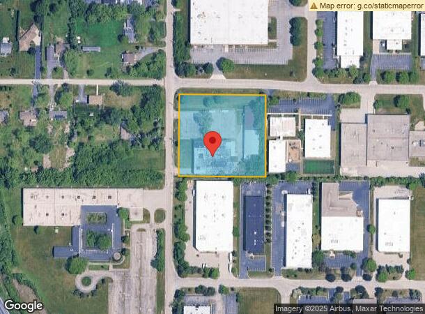
Property Record
28041 N Bradley Rd, Lake Forest, IL 60045
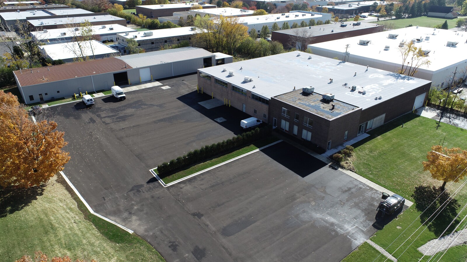
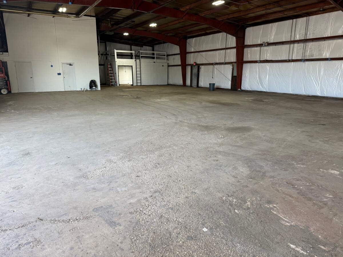
This Property Is For Sale
Current Lease Availabilities
NEARBY LISTINGS FOR SALE OR LEASE
Property Detail
28041 N Bradley Rd
Chicago-Naperville-Elgin, IL-IN-WI
Com At Sw Cor
11-24-300-005
COM AT SW COR 1/4 SD SEC TH E ALG S LN 400FT TH N AT RA TO S D S LN 340FT TH W PARL TO SD S LN TO W LN SD 1/4 SEC TH S AL G SD W LN TO POB PT SW1/4 SW1/4 24-44-11 SECTION 24 TOWNSHIP
Industrialgeneral
Lake
X
Illinois
17097C0169K
3.13 AC
2022
South Lake County
2023
Chicago
866200
DEMOGRAPHICS near 28041 N Bradley Rd
1 Mile
3 Mile
5 Mile
2024 Total Population
1,082
31,721
120,710
2029 Population
1,122
31,708
120,480
Pop Growth 2024-2029
+ 3.70%
(0.04%)
(0.19%)
Average Age
48
42
39
2024 Total Households
338
12,101
42,264
HH Growth 2024-2029
+ 4.44%
(0.18%)
(0.20%)
Median Household Inc
$134,091
$126,431
$114,820
Avg Household Size
2.60
2.50
2.60
2024 Avg HH Vehicles
2.00
2.00
2.00
Median Home Value
$708,121
$485,981
$463,638
Median Year Built
2001
1980
1980
Nearby Places
- Restaurants
- Banks
- Shops
- Fitness
- Groceries
PUBLIC TRANSPORTATION
COMMUTER RAIL
Libertyville Station (Milwaukee District North Line - Northeast Illinois Regional Commuter Railroad (Metra))
DRIVE
WALK
Distance
Libertyville Station (Milwaukee District North Line - Northeast Illinois Regional Commuter Railroad (Metra))
8 min
3.9 mi
Lake Bluff Station (Union Pacific North Line - Northeast Illinois Regional Commuter Railroad (Metra))
DRIVE
WALK
Distance
Lake Bluff Station (Union Pacific North Line - Northeast Illinois Regional Commuter Railroad (Metra))
9 min
4.2 mi
AIRPORT
Chicago O'Hare International
DRIVE
WALK
Distance
Chicago O'Hare International
33 min
23.1 mi
Freight Ports
Port Milwaukee
DRIVE
WALK
Distance
Port Milwaukee
67 min
55.9 mi
Nearby Properties
Address
Land Use
TOTAL SIZE
Lot Size
Zoning
Address
Land Use
TOTAL SIZE
Lot Size
Zoning
182.08 AC
Address
Land Use
TOTAL SIZE
Lot Size
Zoning
74.05 AC
Address
Land Use
TOTAL SIZE
Lot Size
Zoning
12.96 AC
Address
Land Use
TOTAL SIZE
Lot Size
Zoning
23.12 AC
Address
Land Use
TOTAL SIZE
Lot Size
Zoning
145.94 AC
Address
Land Use
TOTAL SIZE
Lot Size
Zoning
19.92 AC
Address
Land Use
TOTAL SIZE
Lot Size
Zoning
Address
Land Use
TOTAL SIZE
Lot Size
Zoning
36,797,586 SF
48.98 AC
Address
Land Use
TOTAL SIZE
Lot Size
Zoning
296.29 AC
Address
Land Use
TOTAL SIZE
Lot Size
Zoning
13.85 AC
Address
Land Use
TOTAL SIZE
Lot Size
Zoning
17.35 AC
Address
Land Use
TOTAL SIZE
Lot Size
Zoning
Address
Land Use
TOTAL SIZE
Lot Size
Zoning
Address
Land Use
TOTAL SIZE
Lot Size
Zoning
25.66 AC
Address
Land Use
TOTAL SIZE
Lot Size
Zoning
12.45 AC
Address
Land Use
TOTAL SIZE
Lot Size
Zoning
Address
Land Use
TOTAL SIZE
Lot Size
Zoning
7.98 AC
Address
Land Use
TOTAL SIZE
Lot Size
Zoning
10.68 AC
Address
Land Use
TOTAL SIZE
Lot Size
Zoning
10.24 AC
Address
Land Use
TOTAL SIZE
Lot Size
Zoning
14.03 AC
Address
Land Use
TOTAL SIZE
Lot Size
Zoning
16.06 AC
Address
Land Use
TOTAL SIZE
Lot Size
Zoning
15.47 AC
Address
Land Use
TOTAL SIZE
Lot Size
Zoning
15.23 AC
Address
Land Use
TOTAL SIZE
Lot Size
Zoning
7.99 AC
Address
Land Use
TOTAL SIZE
Lot Size
Zoning
15.18 AC
Address
Land Use
TOTAL SIZE
Lot Size
Zoning
Address
Land Use
TOTAL SIZE
Lot Size
Zoning
Address
Land Use
TOTAL SIZE
Lot Size
Zoning
8.81 AC
Address
Land Use
TOTAL SIZE
Lot Size
Zoning
225,626 SF
4.11 AC
Address
Land Use
TOTAL SIZE
Lot Size
Zoning
148,512 SF
1.83 AC
The World's #1 Commercial Real Estate Marketplace
Connect with us
© 2025 CoStar Group
The information above has been obtained from sources believed reliable. While we do not doubt its accuracy we have not verified it and make no guarantee, warranty or representation about it. It is your responsibility to independently confirm its accuracy and completeness. Any projections, opinions, assumptions, or estimates used are for example only and do not represent the current or future performance of the property. The value of this transaction to you depends on tax and other factors which should be evaluated by your tax, financial, and legal advisors. You and your advisors should conduct a careful, independent investigation of the property to determine to your satisfaction the suitability of the property for your needs.