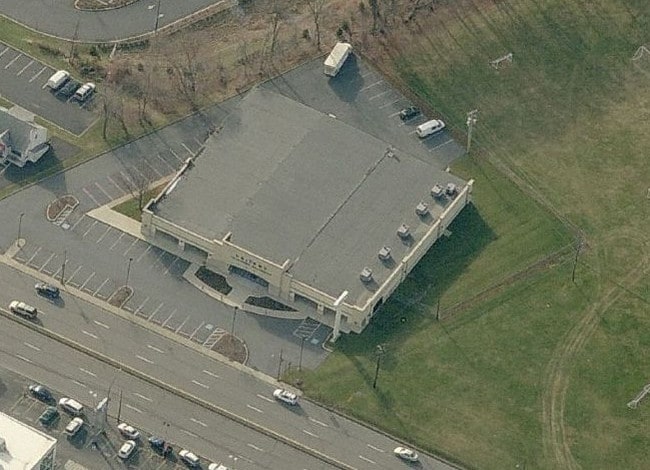
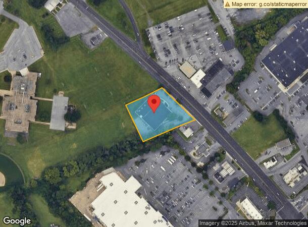
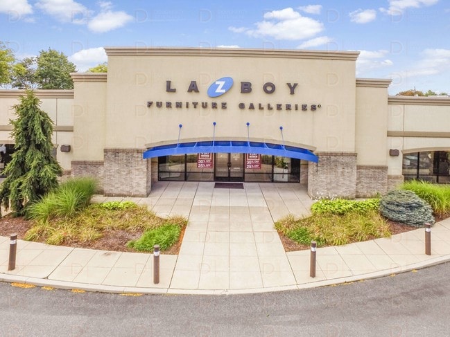
Property Record
2814 Macarthur Rd, Whitehall, PA 18052

NEARBY LISTINGS FOR SALE OR LEASE
Property Detail
2814 Macarthur Rd
549836767230-1
LOTS: 005
Storebuilding
Lehigh
X
Pennsylvania
42095C0238E
5
2025
1.59 AC
2025
Lehigh Valley
005705
Philadelphia
22,540 SF
Allentown-Bethlehem-Easton, PA-NJ
DEMOGRAPHICS near 2814 Macarthur Rd
1 Mile
3 Mile
5 Mile
2024 Total Population
7,415
86,796
210,080
2029 Population
7,438
87,251
211,670
Pop Growth 2024-2029
+ 0.31%
+ 0.52%
+ 0.76%
Average Age
44
39
39
2024 Total Households
3,011
32,954
80,222
HH Growth 2024-2029
+ 0.17%
+ 0.51%
+ 0.82%
Median Household Inc
$65,061
$59,656
$57,590
Avg Household Size
2.40
2.50
2.50
2024 Avg HH Vehicles
2.00
2.00
2.00
Median Home Value
$233,930
$200,596
$210,068
Median Year Built
1970
1956
1959
Nearby Places
Map Layers
Map Styles
 Street
 Aerial
- Restaurants
- Banks
- Shops
- Fitness
- Groceries
PUBLIC TRANSPORTATION
AIRPORT
Lehigh Valley International
DRIVE
WALK
Distance
Lehigh Valley International
8 min
3.8 mi
Freight Ports
Port of Philadelphia
DRIVE
WALK
Distance
Port of Philadelphia
84 min
64.6 mi
SALE & LEASE HISTORY
LISTING DATE
SALE/LEASE

Oct 25, 2019
For Sale
Nearby Properties
Address
Land Use
TOTAL SIZE
Lot Size
Zoning
Address
Land Use
TOTAL SIZE
Lot Size
Zoning
74,985 SF
112.49 AC
RR-2
Address
Land Use
TOTAL SIZE
Lot Size
Zoning
298,543 SF
55.08 AC
PIO
Address
Land Use
TOTAL SIZE
Lot Size
Zoning
230,853 SF
96.66 AC
R-3
Address
Land Use
TOTAL SIZE
Lot Size
Zoning
505,128 SF
25.92 AC
C-2
Address
Land Use
TOTAL SIZE
Lot Size
Zoning
453,600 SF
32.57 AC
PIO
Address
Land Use
TOTAL SIZE
Lot Size
Zoning
175,714 SF
46.35 AC
R-3
Address
Land Use
TOTAL SIZE
Lot Size
Zoning
1,046,625 SF
69.55 AC
RS
Address
Land Use
TOTAL SIZE
Lot Size
Zoning
520,201 SF
77.66 AC
PIO
Address
Land Use
TOTAL SIZE
Lot Size
Zoning
25.75 AC
B/LI
Address
Land Use
TOTAL SIZE
Lot Size
Zoning
504,475 SF
39.36 AC
I
Address
Land Use
TOTAL SIZE
Lot Size
Zoning
72,678 SF
17.21 AC
PC
Address
Land Use
TOTAL SIZE
Lot Size
Zoning
260,803 SF
36.23 AC
C-2
Address
Land Use
TOTAL SIZE
Lot Size
Zoning
1,050,392 SF
218.15 AC
RS
Address
Land Use
TOTAL SIZE
Lot Size
Zoning
113,162 SF
3.02 AC
B/LI
Address
Land Use
TOTAL SIZE
Lot Size
Zoning
214,790 SF
12.09 AC
GC-1
Address
Land Use
TOTAL SIZE
Lot Size
Zoning
123,432 SF
30.70 AC
C-2
Address
Land Use
TOTAL SIZE
Lot Size
Zoning
208,086 SF
3.13 AC
R-H
Address
Land Use
TOTAL SIZE
Lot Size
Zoning
326,320 SF
11.73 AC
PC
Address
Land Use
TOTAL SIZE
Lot Size
Zoning
133,912 SF
0.79 AC
I-3
Address
Land Use
TOTAL SIZE
Lot Size
Zoning
79,400 SF
4.10 AC
GC-1
Address
Land Use
TOTAL SIZE
Lot Size
Zoning
124,515 SF
8.03 AC
I-G
Address
Land Use
TOTAL SIZE
Lot Size
Zoning
8,352 SF
17.24 AC
MR
Address
Land Use
TOTAL SIZE
Lot Size
Zoning
78,095 SF
2.75 AC
B-3
Address
Land Use
TOTAL SIZE
Lot Size
Zoning
29,035 SF
33.70 AC
C-2
Address
Land Use
TOTAL SIZE
Lot Size
Zoning
2,376 SF
19.91 AC
R-5
Address
Land Use
TOTAL SIZE
Lot Size
Zoning
60,052 SF
23.96 AC
C-2
Address
Land Use
TOTAL SIZE
Lot Size
Zoning
50,343 SF
10 AC
R-3A
Address
Land Use
TOTAL SIZE
Lot Size
Zoning
45,176 SF
11.04 AC
R-4
Address
Land Use
TOTAL SIZE
Lot Size
Zoning
77,455 SF
12.09 AC
R-4
Address
Land Use
TOTAL SIZE
Lot Size
Zoning
95,776 SF
23.70 AC
INS
The World's #1 Commercial Real Estate Marketplace
Connect with us
© 2026 CoStar Group
The information above has been obtained from sources believed reliable. While we do not doubt its accuracy we have not verified it and make no guarantee, warranty or representation about it. It is your responsibility to independently confirm its accuracy and completeness. Any projections, opinions, assumptions, or estimates used are for example only and do not represent the current or future performance of the property. The value of this transaction to you depends on tax and other factors which should be evaluated by your tax, financial, and legal advisors. You and your advisors should conduct a careful, independent investigation of the property to determine to your satisfaction the suitability of the property for your needs.