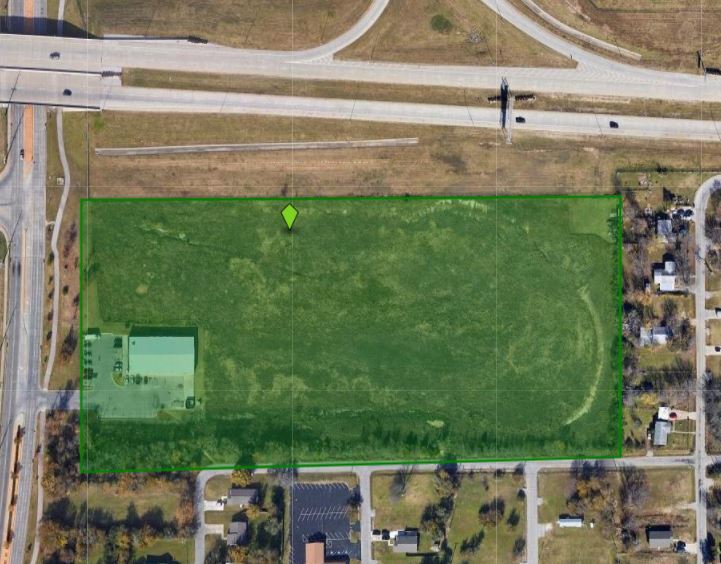
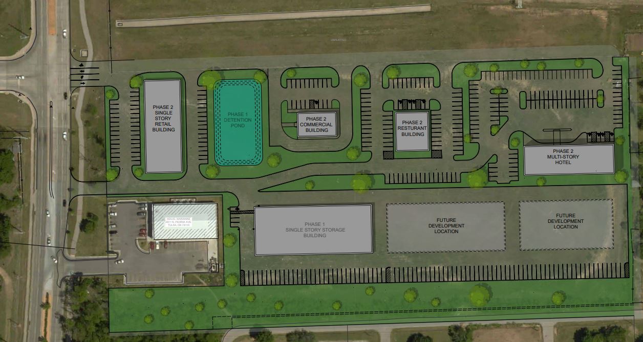
Property Record
2817 N Peoria Ave, Tulsa, OK 74106
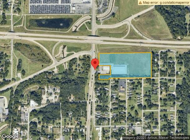
NEARBY LISTINGS FOR SALE OR LEASE
Property Detail
2817 N Peoria Ave
Tulsa, OK
Unplatted
90319-03-19-38530
PRT GOV LT 3 OR NW SW BEG 1319.73S & 100E NWC GOV LT 3 TH N527.32 E10 E1057.18 S527.27 W1067.73 POB LESS BEG 1228.54S & 100E NWC GOV LT 3 TH N186 E235 S186 W235 POB & LESS S25 E857.12 THEREOF SEC 19 20 13 11.425ACS
Publicstorage
Tulsa
X
Oklahoma
40143C0228L
3
2023
11.42 AC
2024
Northwest
000200
Tulsa
24,000 SF
DEMOGRAPHICS near 2817 N Peoria Ave
1 Mile
3 Mile
5 Mile
2024 Total Population
7,449
60,154
129,246
2029 Population
7,898
63,148
135,361
Pop Growth 2024-2029
+ 6.03%
+ 4.98%
+ 4.73%
Average Age
37
36
37
2024 Total Households
3,017
22,003
52,551
HH Growth 2024-2029
+ 6.13%
+ 5.14%
+ 4.96%
Median Household Inc
$26,418
$34,363
$42,115
Avg Household Size
2.40
2.50
2.30
2024 Avg HH Vehicles
1.00
2.00
2.00
Median Home Value
$78,135
$76,513
$109,724
Median Year Built
1960
1957
1956
Nearby Places
- Restaurants
- Banks
- Shops
- Fitness
- Groceries
PUBLIC TRANSPORTATION
AIRPORT
Tulsa International
DRIVE
WALK
Distance
Tulsa International
11 min
5.8 mi
Freight Ports
Tulsa Port Of Catoosa
DRIVE
WALK
Distance
Tulsa Port Of Catoosa
21 min
14.0 mi
SALE & LEASE HISTORY
LISTING DATE
SALE/LEASE

Sep 24, 2016
For Sale
Jun 01, 2019
For Lease
Nearby Properties
Address
Land Use
TOTAL SIZE
Lot Size
Zoning
Address
Land Use
TOTAL SIZE
Lot Size
Zoning
423,825 SF
23.97 AC
CBD
Address
Land Use
TOTAL SIZE
Lot Size
Zoning
692,068 SF
1.03 AC
CBD
Address
Land Use
TOTAL SIZE
Lot Size
Zoning
10,736 SF
101.62 AC
Address
Land Use
TOTAL SIZE
Lot Size
Zoning
87,606 SF
8.25 AC
CBD
Address
Land Use
TOTAL SIZE
Lot Size
Zoning
144,570 SF
44.59 AC
RM2
Address
Land Use
TOTAL SIZE
Lot Size
Zoning
94,115 SF
15.18 AC
IM
Address
Land Use
TOTAL SIZE
Lot Size
Zoning
56,049 SF
1.14 AC
CBD
Address
Land Use
TOTAL SIZE
Lot Size
Zoning
195,492 SF
17.11 AC
RM1
Address
Land Use
TOTAL SIZE
Lot Size
Zoning
333,000 SF
1.32 AC
CBD
Address
Land Use
TOTAL SIZE
Lot Size
Zoning
67,334 SF
0.84 AC
IL
Address
Land Use
TOTAL SIZE
Lot Size
Zoning
106,579 SF
6.76 AC
RM1
Address
Land Use
TOTAL SIZE
Lot Size
Zoning
38,908 SF
2.39 AC
IM
Address
Land Use
TOTAL SIZE
Lot Size
Zoning
40,433 SF
2.92 AC
IL
Address
Land Use
TOTAL SIZE
Lot Size
Zoning
121,518 SF
8.52 AC
IM
Address
Land Use
TOTAL SIZE
Lot Size
Zoning
149,204 SF
3.48 AC
CH
Address
Land Use
TOTAL SIZE
Lot Size
Zoning
333,000 SF
1.28 AC
CBD
Address
Land Use
TOTAL SIZE
Lot Size
Zoning
53,337 SF
3.03 AC
FBC
Address
Land Use
TOTAL SIZE
Lot Size
Zoning
56,476 SF
2.89 AC
RM2
Address
Land Use
TOTAL SIZE
Lot Size
Zoning
66,355 SF
3.06 AC
CBD
Address
Land Use
TOTAL SIZE
Lot Size
Zoning
8,547 SF
0.32 AC
CBD
Address
Land Use
TOTAL SIZE
Lot Size
Zoning
29,584 SF
2.99 AC
IM
Address
Land Use
TOTAL SIZE
Lot Size
Zoning
99,468 SF
1.10 AC
CBD
Address
Land Use
TOTAL SIZE
Lot Size
Zoning
41,874 SF
35.70 AC
RS3
Address
Land Use
TOTAL SIZE
Lot Size
Zoning
29,110 SF
3.96 AC
IL
Address
Land Use
TOTAL SIZE
Lot Size
Zoning
92,364 SF
8.58 AC
RM1
Address
Land Use
TOTAL SIZE
Lot Size
Zoning
497,385 SF
0.79 AC
CBD
Address
Land Use
TOTAL SIZE
Lot Size
Zoning
21,602 SF
12 AC
FBC
Address
Land Use
TOTAL SIZE
Lot Size
Zoning
44,010 SF
1.78 AC
CH
The World's #1 Commercial Real Estate Marketplace
Connect with us
© 2025 CoStar Group
The information above has been obtained from sources believed reliable. While we do not doubt its accuracy we have not verified it and make no guarantee, warranty or representation about it. It is your responsibility to independently confirm its accuracy and completeness. Any projections, opinions, assumptions, or estimates used are for example only and do not represent the current or future performance of the property. The value of this transaction to you depends on tax and other factors which should be evaluated by your tax, financial, and legal advisors. You and your advisors should conduct a careful, independent investigation of the property to determine to your satisfaction the suitability of the property for your needs.