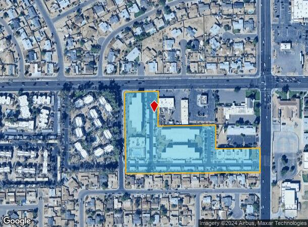
Property Record
6025 W Thomas Rd, Phoenix, AZ 85033


NEARBY LISTINGS FOR SALE OR LEASE
-
-
-
-
-
-
-
NWC Of 77th And Indian School Rd @ W Indian School Rd
Phoenix, AZ 85033
$1,689,715
2.36 AC Lots
Land
-
-
-
-
-
-
View all Phoenix listings for sale on LoopNet.com
Property Detail
6025 W Thomas Rd
Phoenix-Mesa-Scottsdale, AZ
Coyotes Acres
103-14-346
COYOTES ACRES MCR 364-13
Apartment
Maricopa
X
Arizona
04013C2180L
2
2025
6.21 AC
2025
Glendale
112504
Phoenix
174,348 SF
DEMOGRAPHICS near 6025 W Thomas Rd
1 Mile
3 Mile
5 Mile
2024 Total Population
28,282
184,860
434,682
2029 Population
30,333
198,227
467,771
Pop Growth 2024-2029
+ 7.25%
+ 7.23%
+ 7.61%
Average Age
32
32
32
2024 Total Households
7,083
51,590
122,715
HH Growth 2024-2029
+ 7.33%
+ 7.37%
+ 7.83%
Median Household Inc
$55,174
$49,965
$51,771
Avg Household Size
3.80
3.40
3.30
2024 Avg HH Vehicles
2.00
2.00
2.00
Median Home Value
$195,291
$207,336
$236,021
Median Year Built
1972
1975
1977
Nearby Places
Map Layers
Map Styles
 Street
 Aerial
- Restaurants
- Banks
- Shops
- Fitness
- Groceries
PUBLIC TRANSPORTATION
AIRPORT
Phoenix Sky Harbor International
DRIVE
WALK
Distance
Phoenix Sky Harbor International
21 min
14.1 mi
Freight Ports
Port of San Diego
DRIVE
WALK
Distance
Port of San Diego
389 min
349.2 mi
SALE & LEASE HISTORY
LISTING DATE
SALE/LEASE

Sep 24, 2016
For Sale
Feb 02, 2018
For Sale
Nearby Properties
Address
Land Use
TOTAL SIZE
Lot Size
Zoning
Address
Land Use
TOTAL SIZE
Lot Size
Zoning
569,517 SF
33.38 AC
PUD
Address
Land Use
TOTAL SIZE
Lot Size
Zoning
1,539,348 SF
143.97 AC
A-1
Address
Land Use
TOTAL SIZE
Lot Size
Zoning
1,267,497 SF
70.43 AC
A1
Address
Land Use
TOTAL SIZE
Lot Size
Zoning
1,100,500 SF
57.61 AC
PUD
Address
Land Use
TOTAL SIZE
Lot Size
Zoning
1,063,188 SF
59.94 AC
Address
Land Use
TOTAL SIZE
Lot Size
Zoning
4,900 SF
12.05 AC
R1-6
Address
Land Use
TOTAL SIZE
Lot Size
Zoning
281,038 SF
7.71 AC
Address
Land Use
TOTAL SIZE
Lot Size
Zoning
348,753 SF
19.36 AC
R-6
Address
Land Use
TOTAL SIZE
Lot Size
Zoning
659,834 SF
42.04 AC
R-6
Address
Land Use
TOTAL SIZE
Lot Size
Zoning
351,903 SF
29.13 AC
A1
Address
Land Use
TOTAL SIZE
Lot Size
Zoning
436,817 SF
23.21 AC
I-P
Address
Land Use
TOTAL SIZE
Lot Size
Zoning
316,386 SF
45.04 AC
R16
Address
Land Use
TOTAL SIZE
Lot Size
Zoning
592,330 SF
36.89 AC
I-2
Address
Land Use
TOTAL SIZE
Lot Size
Zoning
25.91 AC
A1
Address
Land Use
TOTAL SIZE
Lot Size
Zoning
350,874 SF
28.66 AC
C-C
Address
Land Use
TOTAL SIZE
Lot Size
Zoning
660,807 SF
31.44 AC
PAD-14
Address
Land Use
TOTAL SIZE
Lot Size
Zoning
554,011 SF
26.10 AC
I-P
Address
Land Use
TOTAL SIZE
Lot Size
Zoning
532,713 SF
27.31 AC
Address
Land Use
TOTAL SIZE
Lot Size
Zoning
498,064 SF
12.92 AC
C-N
Address
Land Use
TOTAL SIZE
Lot Size
Zoning
874,407 SF
38.57 AC
I-P
Address
Land Use
TOTAL SIZE
Lot Size
Zoning
587,158 SF
36.23 AC
I-P
Address
Land Use
TOTAL SIZE
Lot Size
Zoning
543,745 SF
31.09 AC
I-1
Address
Land Use
TOTAL SIZE
Lot Size
Zoning
454,368 SF
23.36 AC
I-1
Address
Land Use
TOTAL SIZE
Lot Size
Zoning
74,208 SF
7.25 AC
I-P
Address
Land Use
TOTAL SIZE
Lot Size
Zoning
313,110 SF
18.08 AC
I-1
Address
Land Use
TOTAL SIZE
Lot Size
Zoning
132,597 SF
59.45 AC
C-2
Address
Land Use
TOTAL SIZE
Lot Size
Zoning
92,600 SF
20 AC
C-C
Address
Land Use
TOTAL SIZE
Lot Size
Zoning
367,133 SF
17.88 AC
IND.PK.
Address
Land Use
TOTAL SIZE
Lot Size
Zoning
241,557 SF
20.02 AC
CPGCP
Address
Land Use
TOTAL SIZE
Lot Size
Zoning
176,657 SF
12.28 AC
I-1
The World's #1 Commercial Real Estate Marketplace
Connect with us
© 2025 CoStar Group
The information above has been obtained from sources believed reliable. While we do not doubt its accuracy we have not verified it and make no guarantee, warranty or representation about it. It is your responsibility to independently confirm its accuracy and completeness. Any projections, opinions, assumptions, or estimates used are for example only and do not represent the current or future performance of the property. The value of this transaction to you depends on tax and other factors which should be evaluated by your tax, financial, and legal advisors. You and your advisors should conduct a careful, independent investigation of the property to determine to your satisfaction the suitability of the property for your needs.