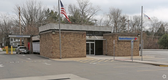
Property Record
2830 Monroe Ave, Rochester, NY 14618


NEARBY LISTINGS FOR SALE OR LEASE
Property Detail
2830 Monroe Ave
262000-150-070-0002-005-000
0007-13-07 EDWARD ROSS LAR2 00
Financialbuilding
Monroe
X
New York
36055C0356G
5.000
2025
0.60 AC
2024
South Central
012600
Rochester
3,010 SF
Rochester, NY
DEMOGRAPHICS near 2830 Monroe Ave
1 Mile
3 Mile
5 Mile
2024 Total Population
5,889
67,881
216,198
2029 Population
5,814
66,884
213,198
Pop Growth 2024-2029
(1.27%)
(1.47%)
(1.39%)
Average Age
43
43
40
2024 Total Households
2,253
30,612
97,406
HH Growth 2024-2029
(1.38%)
(1.61%)
(1.43%)
Median Household Inc
$121,476
$81,958
$64,124
Avg Household Size
2.50
2.10
2.10
2024 Avg HH Vehicles
2.00
2.00
1.00
Median Home Value
$267,079
$252,495
$194,823
Median Year Built
1955
1957
1955
Nearby Places
Map Layers
Map Styles
 Street
 Aerial
- Restaurants
- Banks
- Shops
- Fitness
- Groceries
PUBLIC TRANSPORTATION
COMMUTER RAIL
DRIVE
WALK
Distance
11 min
6.4 mi
AIRPORT
Frederick Douglass/Greater Rochester International
DRIVE
WALK
Distance
Frederick Douglass/Greater Rochester International
13 min
7.5 mi
Nearby Properties
Address
Land Use
TOTAL SIZE
Lot Size
Zoning
Address
Land Use
TOTAL SIZE
Lot Size
Zoning
65,745 SF
154.98 AC
Address
Land Use
TOTAL SIZE
Lot Size
Zoning
7.15 AC
Address
Land Use
TOTAL SIZE
Lot Size
Zoning
70,683 SF
53.22 AC
Address
Land Use
TOTAL SIZE
Lot Size
Zoning
51,276 SF
48.95 AC
02 - SINGL
Address
Land Use
TOTAL SIZE
Lot Size
Zoning
330,090 SF
62.41 AC
Address
Land Use
TOTAL SIZE
Lot Size
Zoning
424,207 SF
39.50 AC
Address
Land Use
TOTAL SIZE
Lot Size
Zoning
130,830 SF
19.20 AC
Address
Land Use
TOTAL SIZE
Lot Size
Zoning
Address
Land Use
TOTAL SIZE
Lot Size
Zoning
209,996 SF
36.56 AC
Address
Land Use
TOTAL SIZE
Lot Size
Zoning
160,758 SF
20.95 AC
02 - SINGL
Address
Land Use
TOTAL SIZE
Lot Size
Zoning
408,790 SF
31.90 AC
02 - SINGL
Address
Land Use
TOTAL SIZE
Lot Size
Zoning
198,655 SF
31.05 AC
02 - SINGL
Address
Land Use
TOTAL SIZE
Lot Size
Zoning
80,747 SF
9.37 AC
02 - SINGL
Address
Land Use
TOTAL SIZE
Lot Size
Zoning
155,517 SF
45.77 AC
Address
Land Use
TOTAL SIZE
Lot Size
Zoning
189,060 SF
30.68 AC
02 - SINGL
Address
Land Use
TOTAL SIZE
Lot Size
Zoning
62,200 SF
17.92 AC
Address
Land Use
TOTAL SIZE
Lot Size
Zoning
11,116 SF
22.60 AC
05 - COMME
Address
Land Use
TOTAL SIZE
Lot Size
Zoning
124,606 SF
10.77 AC
05 - COMME
Address
Land Use
TOTAL SIZE
Lot Size
Zoning
19,440 SF
16.64 AC
03 - MULTI
Address
Land Use
TOTAL SIZE
Lot Size
Zoning
1,878 SF
56.60 AC
MHP
Address
Land Use
TOTAL SIZE
Lot Size
Zoning
126,184 SF
10.42 AC
02 - SINGL
Address
Land Use
TOTAL SIZE
Lot Size
Zoning
8,064 SF
17.42 AC
Address
Land Use
TOTAL SIZE
Lot Size
Zoning
90,684 SF
20.51 AC
LI
Address
Land Use
TOTAL SIZE
Lot Size
Zoning
51,248 SF
28.32 AC
06 - INDUS
Address
Land Use
TOTAL SIZE
Lot Size
Zoning
52,080 SF
21.10 AC
Address
Land Use
TOTAL SIZE
Lot Size
Zoning
38,776 SF
10.33 AC
MR
Address
Land Use
TOTAL SIZE
Lot Size
Zoning
170,387 SF
11.80 AC
02 - SINGL
Address
Land Use
TOTAL SIZE
Lot Size
Zoning
121,867 SF
6.09 AC
05 - COMME
Address
Land Use
TOTAL SIZE
Lot Size
Zoning
107,397 SF
10.62 AC
05 - COMME
Address
Land Use
TOTAL SIZE
Lot Size
Zoning
128,694 SF
15.71 AC
The World's #1 Commercial Real Estate Marketplace
Connect with us
© 2026 CoStar Group
The information above has been obtained from sources believed reliable. While we do not doubt its accuracy we have not verified it and make no guarantee, warranty or representation about it. It is your responsibility to independently confirm its accuracy and completeness. Any projections, opinions, assumptions, or estimates used are for example only and do not represent the current or future performance of the property. The value of this transaction to you depends on tax and other factors which should be evaluated by your tax, financial, and legal advisors. You and your advisors should conduct a careful, independent investigation of the property to determine to your satisfaction the suitability of the property for your needs.