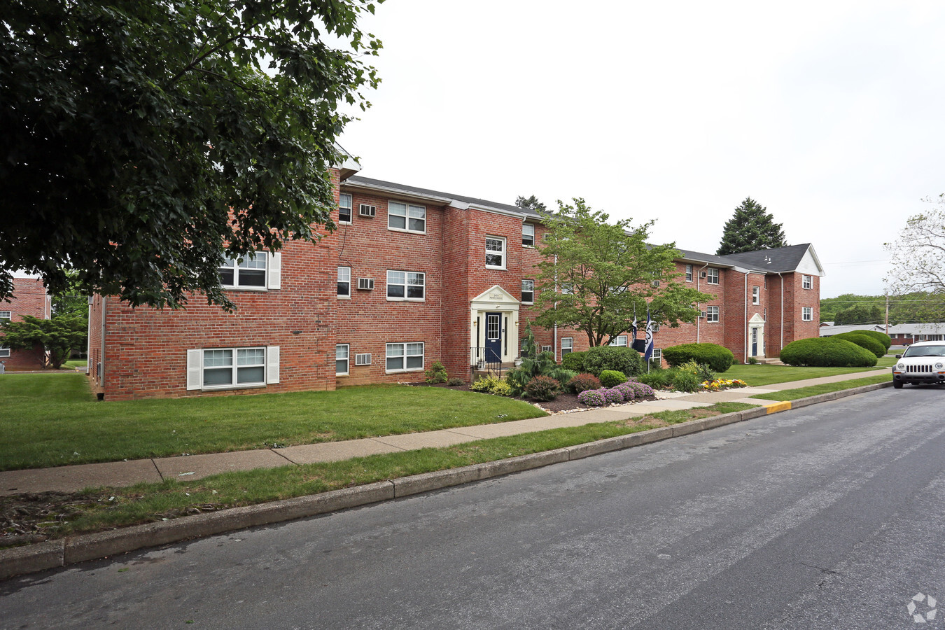
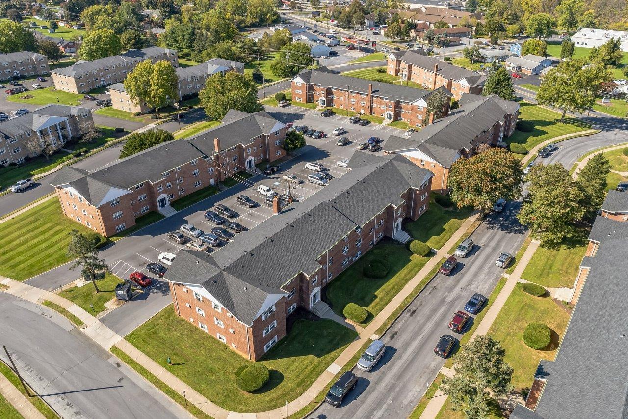
Property Record
2870 W Emaus Ave, Allentown, PA 18103
NEARBY LISTINGS FOR SALE OR LEASE
Property Detail
2870 W Emaus Ave
Allentown-Bethlehem-Easton, PA-NJ
South Mountain Apts
549594545856-1
LOTS: 001
Multifamilydwelling
Lehigh
X
Pennsylvania
42077C0261F
1
2024
3.82 AC
2024
Southside-Lehigh
001502
Philadelphia
15,408 SF
DEMOGRAPHICS near 2870 W Emaus Ave
1 Mile
3 Mile
5 Mile
2024 Total Population
8,259
81,414
206,381
2029 Population
8,425
82,122
207,991
Pop Growth 2024-2029
+ 2.01%
+ 0.87%
+ 0.78%
Average Age
38
39
39
2024 Total Households
3,390
31,635
77,845
HH Growth 2024-2029
+ 1.95%
+ 0.92%
+ 0.83%
Median Household Inc
$56,355
$57,770
$61,075
Avg Household Size
2.40
2.40
2.50
2024 Avg HH Vehicles
2.00
2.00
2.00
Median Home Value
$185,157
$199,727
$233,374
Median Year Built
1971
1959
1961
Nearby Places
- Restaurants
- Banks
- Shops
- Fitness
- Groceries
PUBLIC TRANSPORTATION
AIRPORT
Lehigh Valley International
DRIVE
WALK
Distance
Lehigh Valley International
18 min
9.5 mi
Freight Ports
Port of Philadelphia
DRIVE
WALK
Distance
Port of Philadelphia
82 min
51.5 mi
Nearby Properties
Address
Land Use
TOTAL SIZE
Lot Size
Zoning
Address
Land Use
TOTAL SIZE
Lot Size
Zoning
504,141 SF
44.47 AC
R2
Address
Land Use
TOTAL SIZE
Lot Size
Zoning
413,834 SF
40 AC
R-L
Address
Land Use
TOTAL SIZE
Lot Size
Zoning
285,048 SF
4.34 AC
I-G
Address
Land Use
TOTAL SIZE
Lot Size
Zoning
300,783 SF
0.64 AC
B-2
Address
Land Use
TOTAL SIZE
Lot Size
Zoning
135,668 SF
5 AC
R3
Address
Land Use
TOTAL SIZE
Lot Size
Zoning
112,456 SF
5 AC
R3
Address
Land Use
TOTAL SIZE
Lot Size
Zoning
113,608 SF
6.43 AC
I-G
Address
Land Use
TOTAL SIZE
Lot Size
Zoning
335,939 SF
54 AC
E
Address
Land Use
TOTAL SIZE
Lot Size
Zoning
124,954 SF
1.23 AC
B-2
Address
Land Use
TOTAL SIZE
Lot Size
Zoning
42,250 SF
3.33 AC
I-G
Address
Land Use
TOTAL SIZE
Lot Size
Zoning
48,816 SF
197.98 AC
I-2
Address
Land Use
TOTAL SIZE
Lot Size
Zoning
19,850 SF
15.01 AC
R3
Address
Land Use
TOTAL SIZE
Lot Size
Zoning
166,219 SF
5.16 AC
R-M
Address
Land Use
TOTAL SIZE
Lot Size
Zoning
128,106 SF
10.14 AC
C1
Address
Land Use
TOTAL SIZE
Lot Size
Zoning
139,782 SF
27.47 AC
R4
Address
Land Use
TOTAL SIZE
Lot Size
Zoning
7,200 SF
22.31 AC
I-3
Address
Land Use
TOTAL SIZE
Lot Size
Zoning
44,302 SF
17.25 AC
I-L
Address
Land Use
TOTAL SIZE
Lot Size
Zoning
88,600 SF
3.97 AC
R-H
Address
Land Use
TOTAL SIZE
Lot Size
Zoning
118,272 SF
1.17 AC
B-2
Address
Land Use
TOTAL SIZE
Lot Size
Zoning
266,179 SF
1.33 AC
B-2
Address
Land Use
TOTAL SIZE
Lot Size
Zoning
38,650 SF
11.05 AC
R-H
Address
Land Use
TOTAL SIZE
Lot Size
Zoning
1,154,183 SF
83.21 AC
I-3
Address
Land Use
TOTAL SIZE
Lot Size
Zoning
78,437 SF
1.37 AC
I-G
Address
Land Use
TOTAL SIZE
Lot Size
Zoning
57,764 SF
0.63 AC
I-G
Address
Land Use
TOTAL SIZE
Lot Size
Zoning
118,721 SF
1.28 AC
B-2
Address
Land Use
TOTAL SIZE
Lot Size
Zoning
84,564 SF
20.53 AC
R1
Address
Land Use
TOTAL SIZE
Lot Size
Zoning
63,400 SF
2.84 AC
I-G
Address
Land Use
TOTAL SIZE
Lot Size
Zoning
140,780 SF
21.91 AC
I-G
Address
Land Use
TOTAL SIZE
Lot Size
Zoning
77,347 SF
6.82 AC
E
Address
Land Use
TOTAL SIZE
Lot Size
Zoning
63,204 SF
8.96 AC
R3
The World's #1 Commercial Real Estate Marketplace
Connect with us
© 2025 CoStar Group
The information above has been obtained from sources believed reliable. While we do not doubt its accuracy we have not verified it and make no guarantee, warranty or representation about it. It is your responsibility to independently confirm its accuracy and completeness. Any projections, opinions, assumptions, or estimates used are for example only and do not represent the current or future performance of the property. The value of this transaction to you depends on tax and other factors which should be evaluated by your tax, financial, and legal advisors. You and your advisors should conduct a careful, independent investigation of the property to determine to your satisfaction the suitability of the property for your needs.