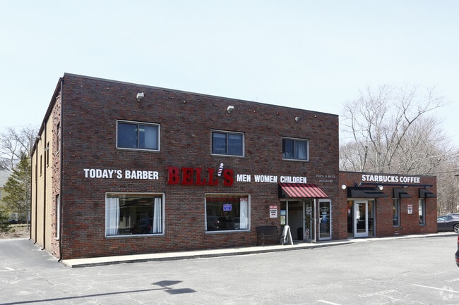
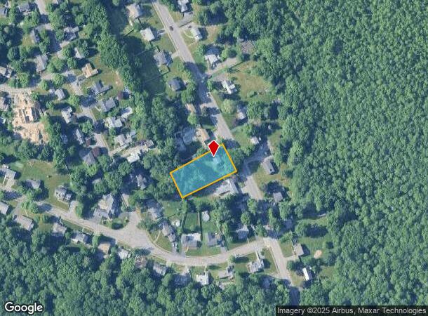
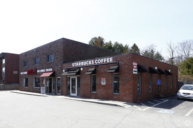
Property Record
230 Haverhill St, Reading, MA 01867
NEARBY LISTINGS FOR SALE OR LEASE
Property Detail
230 Haverhill St
Boston-Cambridge-Newton, MA-NH
Middlesex
READ-000035-000000-000046
Massachusetts
Sfr
0.67 AC
X
Wilmington/Reading
25009C0387G
Boston
1,863 SF
DEMOGRAPHICS near 230 Haverhill St
1 Mile
3 Mile
5 Mile
2024 Total Population
14,124
82,119
203,145
2029 Population
14,074
81,383
201,397
Pop Growth 2024-2029
(0.35%)
(0.90%)
(0.86%)
Average Age
43
42
42
2024 Total Households
5,576
32,548
78,966
HH Growth 2024-2029
(0.48%)
(0.98%)
(0.93%)
Median Household Inc
$115,198
$118,865
$121,628
Avg Household Size
2.50
2.50
2.50
2024 Avg HH Vehicles
2.00
2.00
2.00
Median Home Value
$705,444
$695,045
$706,703
Median Year Built
1960
1961
1962
Nearby Places
Map Layers
Map Styles
 Street
 Aerial
- Restaurants
- Banks
- Shops
- Fitness
- Groceries
PUBLIC TRANSPORTATION
COMMUTER RAIL
Reading (Haverhill Line - Massachusetts Bay Transportation Authority Commuter Rail (Purple Line))
DRIVE
WALK
Distance
Reading (Haverhill Line - Massachusetts Bay Transportation Authority Commuter Rail (Purple Line))
5 min
2.3 mi
Wakefield (Haverhill Line - Massachusetts Bay Transportation Authority Commuter Rail (Purple Line))
DRIVE
WALK
Distance
Wakefield (Haverhill Line - Massachusetts Bay Transportation Authority Commuter Rail (Purple Line))
6 min
2.9 mi
AIRPORT
General Edward Lawrence Logan International
DRIVE
WALK
Distance
General Edward Lawrence Logan International
27 min
17.6 mi
Freight Ports
Port of Boston
DRIVE
WALK
Distance
Port of Boston
27 min
17.3 mi
SALE & LEASE HISTORY
LISTING DATE
SALE/LEASE

Sep 23, 2019
For Lease
Apr 13, 2017
For Lease
Apr 13, 2017
For Lease
Nearby Properties
Address
Land Use
TOTAL SIZE
Lot Size
Zoning
Address
Land Use
TOTAL SIZE
Lot Size
Zoning
42.20 AC
S-2
Address
Land Use
TOTAL SIZE
Lot Size
Zoning
411,956 SF
23.94 AC
S20
Address
Land Use
TOTAL SIZE
Lot Size
Zoning
213,401 SF
15.16 AC
B
Address
Land Use
TOTAL SIZE
Lot Size
Zoning
31.56 AC
HB
Address
Land Use
TOTAL SIZE
Lot Size
Zoning
215,057 SF
12 AC
RB
Address
Land Use
TOTAL SIZE
Lot Size
Zoning
341,593 SF
3.38 AC
I-P2
Address
Land Use
TOTAL SIZE
Lot Size
Zoning
129,028 SF
7.17 AC
I-P2
Address
Land Use
TOTAL SIZE
Lot Size
Zoning
217,937 SF
8.40 AC
I
Address
Land Use
TOTAL SIZE
Lot Size
Zoning
153,906 SF
4 AC
S15
Address
Land Use
TOTAL SIZE
Lot Size
Zoning
172,056 SF
I
Address
Land Use
TOTAL SIZE
Lot Size
Zoning
10.73 AC
I-P2
Address
Land Use
TOTAL SIZE
Lot Size
Zoning
6.28 AC
RB
Address
Land Use
TOTAL SIZE
Lot Size
Zoning
216,337 SF
7.19 AC
S20
Address
Land Use
TOTAL SIZE
Lot Size
Zoning
141,968 SF
11.28 AC
R20
Address
Land Use
TOTAL SIZE
Lot Size
Zoning
6.77 AC
I-P2
Address
Land Use
TOTAL SIZE
Lot Size
Zoning
14,760 SF
1 AC
SR
Address
Land Use
TOTAL SIZE
Lot Size
Zoning
481,812 SF
25.97 AC
I-P2
Address
Land Use
TOTAL SIZE
Lot Size
Zoning
113,502 SF
8.50 AC
LB
Address
Land Use
TOTAL SIZE
Lot Size
Zoning
155,686 SF
2.88 AC
I
Address
Land Use
TOTAL SIZE
Lot Size
Zoning
5.91 AC
I-P2
Address
Land Use
TOTAL SIZE
Lot Size
Zoning
175,682 SF
20.80 AC
IB
Address
Land Use
TOTAL SIZE
Lot Size
Zoning
262,220 SF
11.79 AC
Address
Land Use
TOTAL SIZE
Lot Size
Zoning
254,374 SF
34.70 AC
I
Address
Land Use
TOTAL SIZE
Lot Size
Zoning
141,827 SF
8.10 AC
S15
Address
Land Use
TOTAL SIZE
Lot Size
Zoning
167,470 SF
8.50 AC
B
Address
Land Use
TOTAL SIZE
Lot Size
Zoning
156,846 SF
11.79 AC
Address
Land Use
TOTAL SIZE
Lot Size
Zoning
146,088 SF
8.93 AC
IND
Address
Land Use
TOTAL SIZE
Lot Size
Zoning
135,065 SF
1.58 AC
GR
Address
Land Use
TOTAL SIZE
Lot Size
Zoning
76,854 SF
0.97 AC
S15
Address
Land Use
TOTAL SIZE
Lot Size
Zoning
127,016 SF
11.01 AC
IB
The World's #1 Commercial Real Estate Marketplace
Connect with us
© 2025 CoStar Group
The information above has been obtained from sources believed reliable. While we do not doubt its accuracy we have not verified it and make no guarantee, warranty or representation about it. It is your responsibility to independently confirm its accuracy and completeness. Any projections, opinions, assumptions, or estimates used are for example only and do not represent the current or future performance of the property. The value of this transaction to you depends on tax and other factors which should be evaluated by your tax, financial, and legal advisors. You and your advisors should conduct a careful, independent investigation of the property to determine to your satisfaction the suitability of the property for your needs.