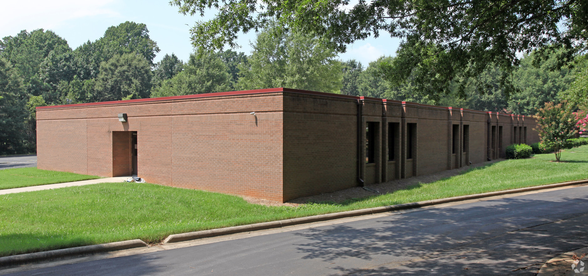
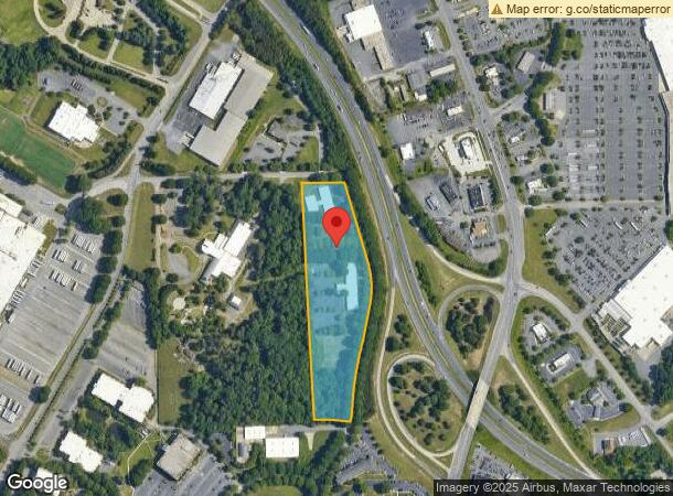
Property Record
289 Mercantile Dr, Winston Salem, NC 27105
NEARBY LISTINGS FOR SALE OR LEASE
Property Detail
289 Mercantile Dr
Winston-Salem, NC
Mount Eagle College
6828-27-7975
MOUNT EAGLE COLLEGE LO105A BL3450 BU1
Publichealthcarefacility
Forsyth
X
North Carolina
3710682800J
105a
2023
9.41 AC
2023
NW Forsyth County
002806
Greensboro/Winston-Salem
35,603 SF
DEMOGRAPHICS near 289 Mercantile Dr
1 Mile
3 Mile
5 Mile
2024 Total Population
2,675
38,118
89,011
2029 Population
2,776
39,799
92,847
Pop Growth 2024-2029
+ 3.78%
+ 4.41%
+ 4.31%
Average Age
37
38
38
2024 Total Households
1,213
16,114
34,901
HH Growth 2024-2029
+ 3.71%
+ 4.36%
+ 4.41%
Median Household Inc
$38,686
$46,453
$53,652
Avg Household Size
2.10
2.20
2.30
2024 Avg HH Vehicles
1.00
2.00
2.00
Median Home Value
$149,856
$158,180
$182,421
Median Year Built
1980
1982
1979
Nearby Places
- Restaurants
- Banks
- Shops
- Fitness
- Groceries
PUBLIC TRANSPORTATION
AIRPORT
Piedmont Triad International
DRIVE
WALK
Distance
Piedmont Triad International
42 min
26.4 mi
Freight Ports
Virginia Port Authority - Richmond
DRIVE
WALK
Distance
Virginia Port Authority - Richmond
269 min
230.0 mi
SALE & LEASE HISTORY
LISTING DATE
SALE/LEASE

Dec 18, 2019
For Lease
Nearby Properties
Address
Land Use
TOTAL SIZE
Lot Size
Zoning
Address
Land Use
TOTAL SIZE
Lot Size
Zoning
410,539 SF
94.76 AC
CPO,GI,RS9
Address
Land Use
TOTAL SIZE
Lot Size
Zoning
153,937 SF
34.63 AC
RM12-S
Address
Land Use
TOTAL SIZE
Lot Size
Zoning
243,307 SF
28.02 AC
GB
Address
Land Use
TOTAL SIZE
Lot Size
Zoning
319,345 SF
58.84 AC
RM18-S
Address
Land Use
TOTAL SIZE
Lot Size
Zoning
152,798 SF
32.40 AC
RM18
Address
Land Use
TOTAL SIZE
Lot Size
Zoning
124,919 SF
35.86 AC
RM18-S
Address
Land Use
TOTAL SIZE
Lot Size
Zoning
85,354 SF
29.13 AC
RM18-S
Address
Land Use
TOTAL SIZE
Lot Size
Zoning
209,521 SF
20.73 AC
HB-S,RS9
Address
Land Use
TOTAL SIZE
Lot Size
Zoning
176,393 SF
28.15 AC
RM18
Address
Land Use
TOTAL SIZE
Lot Size
Zoning
223,590 SF
31.67 AC
HB-S
Address
Land Use
TOTAL SIZE
Lot Size
Zoning
91,713 SF
21.09 AC
RM18-S
Address
Land Use
TOTAL SIZE
Lot Size
Zoning
685,144 SF
38.24 AC
LI
Address
Land Use
TOTAL SIZE
Lot Size
Zoning
7,232 SF
57.50 AC
RM18
Address
Land Use
TOTAL SIZE
Lot Size
Zoning
110,544 SF
43.62 AC
GB-S,IP
Address
Land Use
TOTAL SIZE
Lot Size
Zoning
105,550 SF
14.95 AC
RM12-S
Address
Land Use
TOTAL SIZE
Lot Size
Zoning
106,941 SF
10.91 AC
RM12-S
Address
Land Use
TOTAL SIZE
Lot Size
Zoning
99,460 SF
17.17 AC
RM18
Address
Land Use
TOTAL SIZE
Lot Size
Zoning
67,643 SF
19.19 AC
RM12-S
Address
Land Use
TOTAL SIZE
Lot Size
Zoning
75,243 SF
22.79 AC
HB
Address
Land Use
TOTAL SIZE
Lot Size
Zoning
113,060 SF
16.61 AC
HB-S,RS9
Address
Land Use
TOTAL SIZE
Lot Size
Zoning
89,408 SF
10.57 AC
GI
Address
Land Use
TOTAL SIZE
Lot Size
Zoning
131,606 SF
22.93 AC
GI,HB-S
Address
Land Use
TOTAL SIZE
Lot Size
Zoning
705,599 SF
53.71 AC
GB-L
Address
Land Use
TOTAL SIZE
Lot Size
Zoning
126,791 SF
12.22 AC
IP,IP-S
Address
Land Use
TOTAL SIZE
Lot Size
Zoning
81,392 SF
15.76 AC
GB
Address
Land Use
TOTAL SIZE
Lot Size
Zoning
57,152 SF
9.82 AC
RM18-S
Address
Land Use
TOTAL SIZE
Lot Size
Zoning
89,957 SF
14.65 AC
RM18
Address
Land Use
TOTAL SIZE
Lot Size
Zoning
90,348 SF
17.28 AC
RM18
Address
Land Use
TOTAL SIZE
Lot Size
Zoning
82,667 SF
10.75 AC
RM18
Address
Land Use
TOTAL SIZE
Lot Size
Zoning
33,150 SF
6.90 AC
GB
The World's #1 Commercial Real Estate Marketplace
Connect with us
© 2025 CoStar Group
The information above has been obtained from sources believed reliable. While we do not doubt its accuracy we have not verified it and make no guarantee, warranty or representation about it. It is your responsibility to independently confirm its accuracy and completeness. Any projections, opinions, assumptions, or estimates used are for example only and do not represent the current or future performance of the property. The value of this transaction to you depends on tax and other factors which should be evaluated by your tax, financial, and legal advisors. You and your advisors should conduct a careful, independent investigation of the property to determine to your satisfaction the suitability of the property for your needs.