Property Record
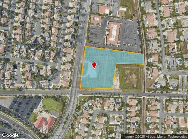
2895 S Main St, Corona, CA 92882
This Property Is For Sale
NEARBY LISTINGS FOR SALE OR LEASE
-
-
-
-
-
-
-
No Photo
-
View all Corona listings for sale on LoopNet.com
Property Detail
2895 S Main St
Riverside-San Bernardino-Ontario, CA
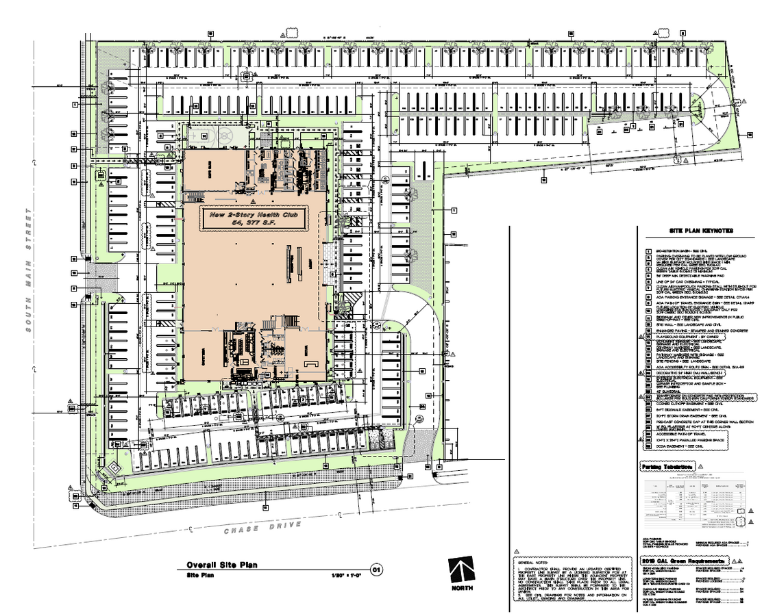
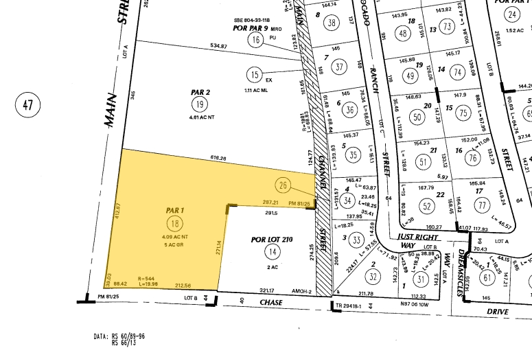
Parcel Map No 15824
113-340-018
Riverside
Residentialnec
California
X
4.09 AC
06059C0225J
Corona/Eastvale
4,067 SF
Inland Empire (California)
DEMOGRAPHICS near 2895 S Main St
1 Mile
3 Mile
5 Mile
2024 Total Population
17,717
105,186
180,254
2029 Population
18,555
110,242
189,209
Pop Growth 2024-2029
+ 4.73%
+ 4.81%
+ 4.97%
Average Age
39
37
37
2024 Total Households
4,913
30,411
52,427
HH Growth 2024-2029
+ 4.13%
+ 4.30%
+ 4.49%
Median Household Inc
$128,934
$97,921
$100,219
Avg Household Size
3.40
3.30
3.30
2024 Avg HH Vehicles
3.00
2.00
2.00
Median Home Value
$724,212
$654,164
$644,239
Median Year Built
1995
1987
1988
Nearby Places
- Restaurants
- Banks
- Shops
- Fitness
- Groceries
PUBLIC TRANSPORTATION
COMMUTER RAIL
North Main Corona (91 Line - Southern California Regional Rail Authority (Metrolink), Inland Empire-Orange County Line - Southern California Regional Rail Authority (Metrolink))
DRIVE
WALK
Distance
North Main Corona (91 Line - Southern California Regional Rail Authority (Metrolink), Inland Empire-Orange County Line - Southern California Regional Rail Authority (Metrolink))
6 min
2.9 mi
West Corona (91 Line - Southern California Regional Rail Authority (Metrolink), Inland Empire-Orange County Line - Southern California Regional Rail Authority (Metrolink))
DRIVE
WALK
Distance
West Corona (91 Line - Southern California Regional Rail Authority (Metrolink), Inland Empire-Orange County Line - Southern California Regional Rail Authority (Metrolink))
9 min
5.7 mi
AIRPORT
Ontario International
DRIVE
WALK
Distance
Ontario International
26 min
18.2 mi
John Wayne/Orange County
DRIVE
WALK
Distance
John Wayne/Orange County
38 min
30.7 mi
Freight Ports
Port of Long Beach
DRIVE
WALK
Distance
Port of Long Beach
59 min
44.7 mi
Nearby Properties
Address
Land Use
TOTAL SIZE
Lot Size
Zoning
Address
Land Use
TOTAL SIZE
Lot Size
Zoning
12.69 AC
Address
Land Use
TOTAL SIZE
Lot Size
Zoning
699,007 SF
6.71 AC
Address
Land Use
TOTAL SIZE
Lot Size
Zoning
29,695 SF
18.71 AC
R3
Address
Land Use
TOTAL SIZE
Lot Size
Zoning
164,712 SF
10 AC
R3
Address
Land Use
TOTAL SIZE
Lot Size
Zoning
173,676 SF
10.96 AC
R3
Address
Land Use
TOTAL SIZE
Lot Size
Zoning
245,658 SF
15.38 AC
PD
Address
Land Use
TOTAL SIZE
Lot Size
Zoning
8.80 AC
R3
Address
Land Use
TOTAL SIZE
Lot Size
Zoning
147,360 SF
16.94 AC
M3
Address
Land Use
TOTAL SIZE
Lot Size
Zoning
421,898 SF
3 AC
Address
Land Use
TOTAL SIZE
Lot Size
Zoning
186,190 SF
9.79 AC
Address
Land Use
TOTAL SIZE
Lot Size
Zoning
205,235 SF
10.30 AC
Address
Land Use
TOTAL SIZE
Lot Size
Zoning
217,299 SF
7.41 AC
Address
Land Use
TOTAL SIZE
Lot Size
Zoning
141,280 SF
9.31 AC
Address
Land Use
TOTAL SIZE
Lot Size
Zoning
152,756 SF
7.07 AC
Address
Land Use
TOTAL SIZE
Lot Size
Zoning
171,707 SF
8.55 AC
Address
Land Use
TOTAL SIZE
Lot Size
Zoning
138,800 SF
10 AC
M4
Address
Land Use
TOTAL SIZE
Lot Size
Zoning
140,216 SF
6.43 AC
Address
Land Use
TOTAL SIZE
Lot Size
Zoning
150,404 SF
8.02 AC
Address
Land Use
TOTAL SIZE
Lot Size
Zoning
111,862 SF
9.98 AC
A
Address
Land Use
TOTAL SIZE
Lot Size
Zoning
311,297 SF
13.39 AC
Address
Land Use
TOTAL SIZE
Lot Size
Zoning
364,162 SF
10 AC
M4
Address
Land Use
TOTAL SIZE
Lot Size
Zoning
63,130 SF
10.20 AC
R3
Address
Land Use
TOTAL SIZE
Lot Size
Zoning
203,476 SF
10.40 AC
C3
Address
Land Use
TOTAL SIZE
Lot Size
Zoning
115,545 SF
5.97 AC
Address
Land Use
TOTAL SIZE
Lot Size
Zoning
175,785 SF
6.29 AC
Address
Land Use
TOTAL SIZE
Lot Size
Zoning
104,740 SF
4.88 AC
Address
Land Use
TOTAL SIZE
Lot Size
Zoning
179,757 SF
6.08 AC
Address
Land Use
TOTAL SIZE
Lot Size
Zoning
130,590 SF
7.42 AC
M3
Address
Land Use
TOTAL SIZE
Lot Size
Zoning
103,323 SF
16.23 AC
Address
Land Use
TOTAL SIZE
Lot Size
Zoning
98,349 SF
4.81 AC
The World's #1 Commercial Real Estate Marketplace
Connect with us
© 2025 CoStar Group
The information above has been obtained from sources believed reliable. While we do not doubt its accuracy we have not verified it and make no guarantee, warranty or representation about it. It is your responsibility to independently confirm its accuracy and completeness. Any projections, opinions, assumptions, or estimates used are for example only and do not represent the current or future performance of the property. The value of this transaction to you depends on tax and other factors which should be evaluated by your tax, financial, and legal advisors. You and your advisors should conduct a careful, independent investigation of the property to determine to your satisfaction the suitability of the property for your needs.