Property Record
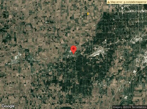
2901 N Berkey Southern Rd, Swanton, OH 43558
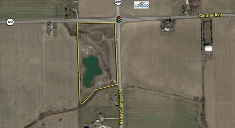
This Property Is For Sale
NEARBY LISTINGS FOR SALE OR LEASE
-
-
View all Swanton listings for sale on LoopNet.com
Property Detail
2901 N Berkey Southern Rd
57-30231
5 9 29 NE 1/4 E 40 AC PT N OF CREEK & SUB TO LEGAL HWYS
Agriculturalland
Lucas
X
Ohio
39095C0040E
20.36 AC
2023
West/Sylvania
2023
Toledo
009500
Toledo, OH
DEMOGRAPHICS near 2901 N Berkey Southern Rd
1 Mile
3 Mile
5 Mile
2024 Total Population
76
1,612
12,582
2029 Population
73
1,559
12,354
Pop Growth 2024-2029
(3.95%)
(3.29%)
(1.81%)
Average Age
45
44
41
2024 Total Households
30
639
4,637
HH Growth 2024-2029
(3.33%)
(3.29%)
(1.94%)
Median Household Inc
$81,250
$85,072
$102,665
Avg Household Size
2.40
2.50
2.70
2024 Avg HH Vehicles
2.00
2.00
2.00
Median Home Value
$237,500
$245,070
$301,584
Median Year Built
1954
1959
1993
Nearby Places
- Restaurants
- Banks
- Shops
- Fitness
- Groceries
PUBLIC TRANSPORTATION
AIRPORT
Eugene F Kranz Toledo Express
DRIVE
WALK
Distance
Eugene F Kranz Toledo Express
14 min
5.2 mi
Freight Ports
Port of Toledo
DRIVE
WALK
Distance
Port of Toledo
43 min
24.8 mi
Nearby Properties
Address
Land Use
TOTAL SIZE
Lot Size
Zoning
Address
Land Use
TOTAL SIZE
Lot Size
Zoning
122,761 SF
49.24 AC
R1
Address
Land Use
TOTAL SIZE
Lot Size
Zoning
8,571 SF
43.96 AC
18-R1
Address
Land Use
TOTAL SIZE
Lot Size
Zoning
42,170 SF
6.55 AC
R2
Address
Land Use
TOTAL SIZE
Lot Size
Zoning
25,714 SF
4.80 AC
R2
Address
Land Use
TOTAL SIZE
Lot Size
Zoning
33,716 SF
2.76 AC
B3
Address
Land Use
TOTAL SIZE
Lot Size
Zoning
22,634 SF
9.43 AC
R1
Address
Land Use
TOTAL SIZE
Lot Size
Zoning
26,838 SF
22.67 AC
R2
Address
Land Use
TOTAL SIZE
Lot Size
Zoning
228.67 AC
33-MX
Address
Land Use
TOTAL SIZE
Lot Size
Zoning
58,438 SF
398.85 AC
33-MX
Address
Land Use
TOTAL SIZE
Lot Size
Zoning
11,068 SF
1.43 AC
B3
Address
Land Use
TOTAL SIZE
Lot Size
Zoning
23,318 SF
8.71 AC
B3
Address
Land Use
TOTAL SIZE
Lot Size
Zoning
4,800 SF
4.05 AC
B3
Address
Land Use
TOTAL SIZE
Lot Size
Zoning
54,293 SF
4.96 AC
B3
Address
Land Use
TOTAL SIZE
Lot Size
Zoning
43,300 SF
10.58 AC
M2
Address
Land Use
TOTAL SIZE
Lot Size
Zoning
26,768 SF
65.40 AC
Address
Land Use
TOTAL SIZE
Lot Size
Zoning
10,000 SF
10.72 AC
M1
Address
Land Use
TOTAL SIZE
Lot Size
Zoning
11,625 SF
0.55 AC
R2
Address
Land Use
TOTAL SIZE
Lot Size
Zoning
39,924 SF
1.63 AC
33-A
Address
Land Use
TOTAL SIZE
Lot Size
Zoning
13,300 SF
4.31 AC
18-B3
Address
Land Use
TOTAL SIZE
Lot Size
Zoning
Address
Land Use
TOTAL SIZE
Lot Size
Zoning
Address
Land Use
TOTAL SIZE
Lot Size
Zoning
24,542 SF
6.29 AC
Address
Land Use
TOTAL SIZE
Lot Size
Zoning
13,880 SF
1.20 AC
18-B3
Address
Land Use
TOTAL SIZE
Lot Size
Zoning
4,058 SF
5.39 AC
R1
Address
Land Use
TOTAL SIZE
Lot Size
Zoning
116.89 AC
Address
Land Use
TOTAL SIZE
Lot Size
Zoning
103.99 AC
Address
Land Use
TOTAL SIZE
Lot Size
Zoning
2,832 SF
103.84 AC
M1
Address
Land Use
TOTAL SIZE
Lot Size
Zoning
11,950 SF
2.07 AC
B3
Address
Land Use
TOTAL SIZE
Lot Size
Zoning
16,016 SF
1 AC
18-B3
Address
Land Use
TOTAL SIZE
Lot Size
Zoning
101.57 AC
The World's #1 Commercial Real Estate Marketplace
Connect with us
© 2025 CoStar Group
The information above has been obtained from sources believed reliable. While we do not doubt its accuracy we have not verified it and make no guarantee, warranty or representation about it. It is your responsibility to independently confirm its accuracy and completeness. Any projections, opinions, assumptions, or estimates used are for example only and do not represent the current or future performance of the property. The value of this transaction to you depends on tax and other factors which should be evaluated by your tax, financial, and legal advisors. You and your advisors should conduct a careful, independent investigation of the property to determine to your satisfaction the suitability of the property for your needs.