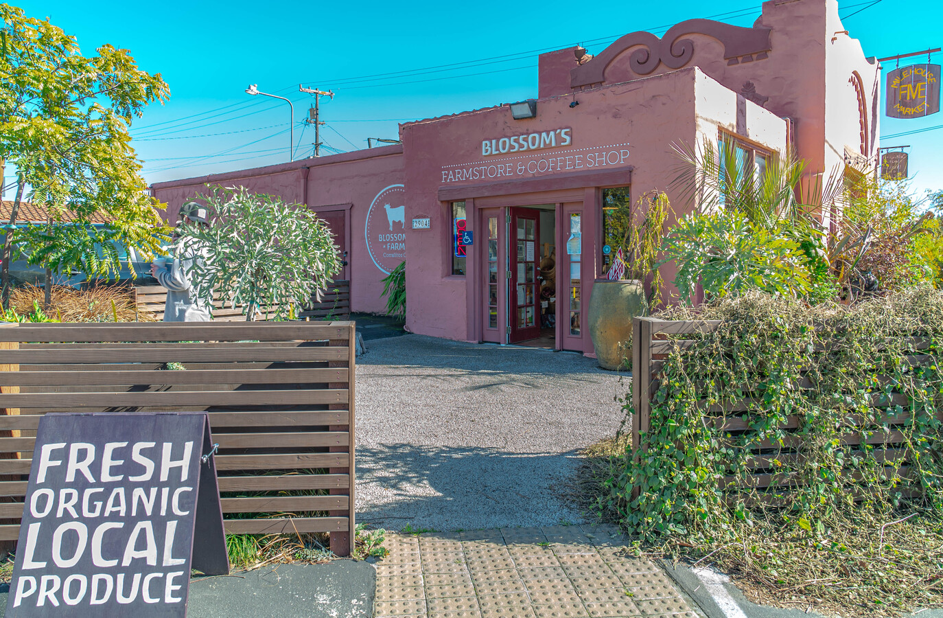
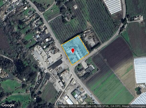
Property Record
2904 Freedom Blvd, Watsonville, CA 95076

NEARBY LISTINGS FOR SALE OR LEASE
-
-
View all Watsonville listings for sale on LoopNet.com
Property Detail
2904 Freedom Blvd
108-191-28-000
Rancho Corralitos
Regionalshoppingcenterormallwithanchorstore
Santa Cruz
X
California
06087C0383E
1.92 AC
2023
Outlying Santa Cruz Cnty
2023
Santa Cruz/Watsonville
122402
Santa Cruz-Watsonville, CA
6,261 SF
DEMOGRAPHICS near 2904 Freedom Blvd
1 Mile
3 Mile
5 Mile
2024 Total Population
1,205
22,246
82,796
2029 Population
1,141
21,423
80,523
Pop Growth 2024-2029
(5.31%)
(3.70%)
(2.75%)
Average Age
43
39
39
2024 Total Households
412
6,344
24,942
HH Growth 2024-2029
(5.83%)
(4.30%)
(2.93%)
Median Household Inc
$112,500
$92,424
$90,755
Avg Household Size
2.90
3.30
3.20
2024 Avg HH Vehicles
3.00
3.00
2.00
Median Home Value
$910,713
$738,938
$817,508
Median Year Built
1973
1972
1974
Nearby Places
- Restaurants
- Banks
- Shops
- Fitness
- Groceries
PUBLIC TRANSPORTATION
AIRPORT
Monterey Regional
DRIVE
WALK
Distance
Monterey Regional
42 min
31.8 mi
Norman Y Mineta San Jose International
DRIVE
WALK
Distance
Norman Y Mineta San Jose International
60 min
44.2 mi
Freight Ports
Port of Redwood City
DRIVE
WALK
Distance
Port of Redwood City
80 min
60.0 mi
SALE & LEASE HISTORY
LISTING DATE
SALE/LEASE

Sep 25, 2016
For Lease
Sep 24, 2016
For Sale
Oct 22, 2018
For Sale
Mar 20, 2023
For Sale
Jun 11, 2024
For Sale
Feb 09, 2021
For Sale
Nearby Properties
Address
Land Use
TOTAL SIZE
Lot Size
Zoning
Address
Land Use
TOTAL SIZE
Lot Size
Zoning
207,360 SF
27.32 AC
Address
Land Use
TOTAL SIZE
Lot Size
Zoning
3,767 SF
6.90 AC
RM-2-R
Address
Land Use
TOTAL SIZE
Lot Size
Zoning
163,824 SF
13.98 AC
Address
Land Use
TOTAL SIZE
Lot Size
Zoning
60,392 SF
4.07 AC
RM-4
Address
Land Use
TOTAL SIZE
Lot Size
Zoning
Address
Land Use
TOTAL SIZE
Lot Size
Zoning
146,574 SF
9.97 AC
Address
Land Use
TOTAL SIZE
Lot Size
Zoning
5,963 SF
7.89 AC
Address
Land Use
TOTAL SIZE
Lot Size
Zoning
8.45 AC
Address
Land Use
TOTAL SIZE
Lot Size
Zoning
22,632 SF
67.25 AC
PF
Address
Land Use
TOTAL SIZE
Lot Size
Zoning
4.59 AC
CA
Address
Land Use
TOTAL SIZE
Lot Size
Zoning
41,700 SF
3 AC
PA
Address
Land Use
TOTAL SIZE
Lot Size
Zoning
39,711 SF
3.88 AC
Address
Land Use
TOTAL SIZE
Lot Size
Zoning
61,561 SF
6.38 AC
Address
Land Use
TOTAL SIZE
Lot Size
Zoning
2.71 AC
Address
Land Use
TOTAL SIZE
Lot Size
Zoning
85,044 SF
6.95 AC
Address
Land Use
TOTAL SIZE
Lot Size
Zoning
54,327 SF
1.25 AC
RM4GH
Address
Land Use
TOTAL SIZE
Lot Size
Zoning
27.77 AC
PR
Address
Land Use
TOTAL SIZE
Lot Size
Zoning
56,387 SF
4.57 AC
RM3
Address
Land Use
TOTAL SIZE
Lot Size
Zoning
11,781 SF
76.71 AC
SU
Address
Land Use
TOTAL SIZE
Lot Size
Zoning
11,460 SF
1.14 AC
Address
Land Use
TOTAL SIZE
Lot Size
Zoning
1,898 SF
51.55 AC
CA
Address
Land Use
TOTAL SIZE
Lot Size
Zoning
31,914 SF
29.21 AC
CA
Address
Land Use
TOTAL SIZE
Lot Size
Zoning
13,998 SF
43 AC
RA
Address
Land Use
TOTAL SIZE
Lot Size
Zoning
7,859 SF
24.43 AC
CA
Address
Land Use
TOTAL SIZE
Lot Size
Zoning
79,554 SF
3.09 AC
Address
Land Use
TOTAL SIZE
Lot Size
Zoning
29,269 SF
3.35 AC
RM-4-GH
Address
Land Use
TOTAL SIZE
Lot Size
Zoning
49,215 SF
2.31 AC
Address
Land Use
TOTAL SIZE
Lot Size
Zoning
5.03 AC
Address
Land Use
TOTAL SIZE
Lot Size
Zoning
1.80 AC
Address
Land Use
TOTAL SIZE
Lot Size
Zoning
61,020 SF
0.73 AC
The World's #1 Commercial Real Estate Marketplace
Connect with us
© 2025 CoStar Group
The information above has been obtained from sources believed reliable. While we do not doubt its accuracy we have not verified it and make no guarantee, warranty or representation about it. It is your responsibility to independently confirm its accuracy and completeness. Any projections, opinions, assumptions, or estimates used are for example only and do not represent the current or future performance of the property. The value of this transaction to you depends on tax and other factors which should be evaluated by your tax, financial, and legal advisors. You and your advisors should conduct a careful, independent investigation of the property to determine to your satisfaction the suitability of the property for your needs.