Property Record
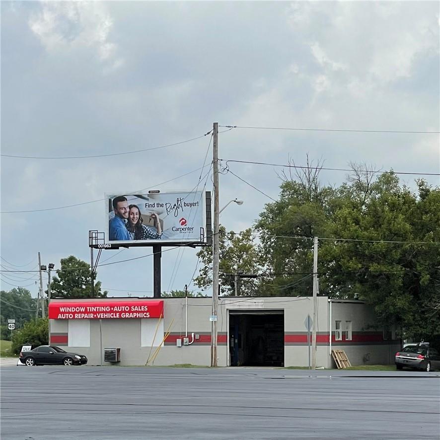
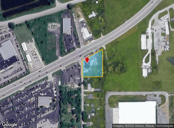
2907 E Main St, Plainfield, IN 46168

This Property Is For Sale
NEARBY LISTINGS FOR SALE OR LEASE
Property Detail
2907 E Main St
32-09-19-495-001.000-027
Plfdwash All Points Tif Area
Autorepair
PT SE SE 191-5-2E 1.55AC DBA; EXTREME WINDOW TINTING SIGNS & GRAPHICS
X
Hendricks
18097C0205F
Indiana
2023
1.55 AC
2024
Hendricks County
210607
Indianapolis
2,537 SF
Indianapolis-Carmel-Anderson, IN
DEMOGRAPHICS near 2907 E Main St
1 Mile
3 Mile
5 Mile
2024 Total Population
2,507
34,790
114,429
2029 Population
2,799
38,028
123,002
Pop Growth 2024-2029
+ 11.65%
+ 9.31%
+ 7.49%
Average Age
37
38
38
2024 Total Households
950
12,888
42,196
HH Growth 2024-2029
+ 11.58%
+ 9.57%
+ 7.52%
Median Household Inc
$81,447
$72,681
$72,454
Avg Household Size
2.50
2.60
2.60
2024 Avg HH Vehicles
2.00
2.00
2.00
Median Home Value
$196,888
$195,117
$201,639
Median Year Built
2005
1996
1994
Nearby Places
- Restaurants
- Banks
- Shops
- Fitness
- Groceries
PUBLIC TRANSPORTATION
AIRPORT
Indianapolis International
DRIVE
WALK
Distance
Indianapolis International
13 min
5.5 mi
Freight Ports
Port of Toledo
DRIVE
WALK
Distance
Port of Toledo
287 min
235.9 mi
Nearby Properties
Address
Land Use
TOTAL SIZE
Lot Size
Zoning
Address
Land Use
TOTAL SIZE
Lot Size
Zoning
1,099,200 SF
68.67 AC
Address
Land Use
TOTAL SIZE
Lot Size
Zoning
1,200,420 SF
68.50 AC
Address
Land Use
TOTAL SIZE
Lot Size
Zoning
939,854 SF
54.08 AC
Address
Land Use
TOTAL SIZE
Lot Size
Zoning
1,144,135 SF
61.59 AC
Address
Land Use
TOTAL SIZE
Lot Size
Zoning
796,988 SF
48.51 AC
Address
Land Use
TOTAL SIZE
Lot Size
Zoning
925,740 SF
82.23 AC
Address
Land Use
TOTAL SIZE
Lot Size
Zoning
66.96 AC
Address
Land Use
TOTAL SIZE
Lot Size
Zoning
56.88 AC
Address
Land Use
TOTAL SIZE
Lot Size
Zoning
950,625 SF
58.10 AC
Address
Land Use
TOTAL SIZE
Lot Size
Zoning
52.77 AC
Address
Land Use
TOTAL SIZE
Lot Size
Zoning
41.50 AC
Address
Land Use
TOTAL SIZE
Lot Size
Zoning
923,980 SF
60.08 AC
Address
Land Use
TOTAL SIZE
Lot Size
Zoning
811,536 SF
42.04 AC
Address
Land Use
TOTAL SIZE
Lot Size
Zoning
822,500 SF
45.66 AC
Address
Land Use
TOTAL SIZE
Lot Size
Zoning
9,728 SF
23.10 AC
Address
Land Use
TOTAL SIZE
Lot Size
Zoning
813,054 SF
45.32 AC
Address
Land Use
TOTAL SIZE
Lot Size
Zoning
43.94 AC
Address
Land Use
TOTAL SIZE
Lot Size
Zoning
770,712 SF
56.53 AC
Address
Land Use
TOTAL SIZE
Lot Size
Zoning
799,264 SF
43.44 AC
Address
Land Use
TOTAL SIZE
Lot Size
Zoning
629,200 SF
39.74 AC
Address
Land Use
TOTAL SIZE
Lot Size
Zoning
706,250 SF
50.53 AC
Address
Land Use
TOTAL SIZE
Lot Size
Zoning
702,000 SF
42.11 AC
Address
Land Use
TOTAL SIZE
Lot Size
Zoning
64.63 AC
Address
Land Use
TOTAL SIZE
Lot Size
Zoning
702,000 SF
36.88 AC
Address
Land Use
TOTAL SIZE
Lot Size
Zoning
5,064 SF
25.50 AC
Address
Land Use
TOTAL SIZE
Lot Size
Zoning
750,820 SF
64.15 AC
Address
Land Use
TOTAL SIZE
Lot Size
Zoning
31.20 AC
Address
Land Use
TOTAL SIZE
Lot Size
Zoning
747,256 SF
41.32 AC
Address
Land Use
TOTAL SIZE
Lot Size
Zoning
720,000 SF
39.03 AC
Address
Land Use
TOTAL SIZE
Lot Size
Zoning
595,938 SF
35.31 AC
The World's #1 Commercial Real Estate Marketplace
Connect with us
© 2025 CoStar Group
The information above has been obtained from sources believed reliable. While we do not doubt its accuracy we have not verified it and make no guarantee, warranty or representation about it. It is your responsibility to independently confirm its accuracy and completeness. Any projections, opinions, assumptions, or estimates used are for example only and do not represent the current or future performance of the property. The value of this transaction to you depends on tax and other factors which should be evaluated by your tax, financial, and legal advisors. You and your advisors should conduct a careful, independent investigation of the property to determine to your satisfaction the suitability of the property for your needs.