Property Record
29200 Northwestern Hwy, Southfield, MI 48034

This Property Is For Sale
Current Lease Availabilities
NEARBY LISTINGS FOR SALE OR LEASE
Property Detail
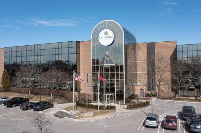
29200 Northwestern Hwy
Detroit-Warren-Dearborn, MI
Suprvrs 2 - Southfield
24-07-326-029
TIN,RICE,SEC 7 SUPERVISORS PLAT NO 2 PART OF LOTS 6 & 7 BEG AT PT DIST N 50-56-00 W 187.50 FT & N 39-04-00 E 114.00 FT FROM
Officebuilding
Oakland
X
Michigan
26125C0518F
6-7
2024
5.17 AC
2025
Southfield
160900
Detroit
120,367 SF
DEMOGRAPHICS near 29200 Northwestern Hwy
1 Mile
3 Mile
5 Mile
2024 Total Population
8,572
59,211
184,437
2029 Population
8,582
58,609
182,046
Pop Growth 2024-2029
+ 0.12%
(1.02%)
(1.30%)
Average Age
43
45
44
2024 Total Households
4,251
26,535
76,720
HH Growth 2024-2029
+ 0.28%
(0.96%)
(1.27%)
Median Household Inc
$60,899
$75,737
$88,307
Avg Household Size
2.00
2.20
2.30
2024 Avg HH Vehicles
2.00
2.00
2.00
Median Home Value
$318,732
$308,336
$290,916
Median Year Built
1975
1971
1968
Nearby Places
Map Layers
Map Styles
 Street
 Aerial
- Restaurants
- Banks
- Shops
- Fitness
- Groceries
PUBLIC TRANSPORTATION
COMMUTER RAIL
DRIVE
WALK
Distance
22 min
9.4 mi
AIRPORT
Windsor International
DRIVE
WALK
Distance
Windsor International
50 min
29.2 mi
Detroit Metro Wayne County
DRIVE
WALK
Distance
Detroit Metro Wayne County
45 min
30.0 mi
Nearby Properties
Address
Land Use
TOTAL SIZE
Lot Size
Zoning
Address
Land Use
TOTAL SIZE
Lot Size
Zoning
558,088 SF
40.09 AC
AI
Address
Land Use
TOTAL SIZE
Lot Size
Zoning
544,945 SF
23.89 AC
BI
Address
Land Use
TOTAL SIZE
Lot Size
Zoning
592,350 SF
23.64 AC
RC
Address
Land Use
TOTAL SIZE
Lot Size
Zoning
32.44 AC
RC
Address
Land Use
TOTAL SIZE
Lot Size
Zoning
439,171 SF
28.57 AC
RMM
Address
Land Use
TOTAL SIZE
Lot Size
Zoning
301,269 SF
25.47 AC
OS
Address
Land Use
TOTAL SIZE
Lot Size
Zoning
346,647 SF
21.12 AC
AI
Address
Land Use
TOTAL SIZE
Lot Size
Zoning
405,020 SF
18.74 AC
RMM
Address
Land Use
TOTAL SIZE
Lot Size
Zoning
271,650 SF
12.88 AC
BI
Address
Land Use
TOTAL SIZE
Lot Size
Zoning
233,598 SF
17.24 AC
RS
Address
Land Use
TOTAL SIZE
Lot Size
Zoning
261,633 SF
12.19 AC
RMM
Address
Land Use
TOTAL SIZE
Lot Size
Zoning
228,544 SF
35.02 AC
BI
Address
Land Use
TOTAL SIZE
Lot Size
Zoning
17.19 AC
RC
Address
Land Use
TOTAL SIZE
Lot Size
Zoning
367,101 SF
37.77 AC
R-E
Address
Land Use
TOTAL SIZE
Lot Size
Zoning
325,654 SF
7.45 AC
ERO
Address
Land Use
TOTAL SIZE
Lot Size
Zoning
246,695 SF
18.46 AC
BI
Address
Land Use
TOTAL SIZE
Lot Size
Zoning
181,954 SF
RC
Address
Land Use
TOTAL SIZE
Lot Size
Zoning
255,136 SF
21.19 AC
AI
Address
Land Use
TOTAL SIZE
Lot Size
Zoning
248,911 SF
4.55 AC
RC
Address
Land Use
TOTAL SIZE
Lot Size
Zoning
63,550 SF
4.18 AC
AI
Address
Land Use
TOTAL SIZE
Lot Size
Zoning
306,250 SF
14.60 AC
RC
Address
Land Use
TOTAL SIZE
Lot Size
Zoning
Address
Land Use
TOTAL SIZE
Lot Size
Zoning
280,984 SF
11.88 AC
ERO-M
Address
Land Use
TOTAL SIZE
Lot Size
Zoning
276,825 SF
19.05 AC
AI
Address
Land Use
TOTAL SIZE
Lot Size
Zoning
288,641 SF
13.56 AC
RMM
Address
Land Use
TOTAL SIZE
Lot Size
Zoning
142,043 SF
17.87 AC
AI
Address
Land Use
TOTAL SIZE
Lot Size
Zoning
210 SF
20.52 AC
R-2
Address
Land Use
TOTAL SIZE
Lot Size
Zoning
216 SF
14.26 AC
RC
Address
Land Use
TOTAL SIZE
Lot Size
Zoning
257,000 SF
10.56 AC
RC
Address
Land Use
TOTAL SIZE
Lot Size
Zoning
The World's #1 Commercial Real Estate Marketplace
Connect with us
© 2026 CoStar Group
The information above has been obtained from sources believed reliable. While we do not doubt its accuracy we have not verified it and make no guarantee, warranty or representation about it. It is your responsibility to independently confirm its accuracy and completeness. Any projections, opinions, assumptions, or estimates used are for example only and do not represent the current or future performance of the property. The value of this transaction to you depends on tax and other factors which should be evaluated by your tax, financial, and legal advisors. You and your advisors should conduct a careful, independent investigation of the property to determine to your satisfaction the suitability of the property for your needs.