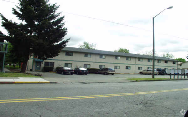
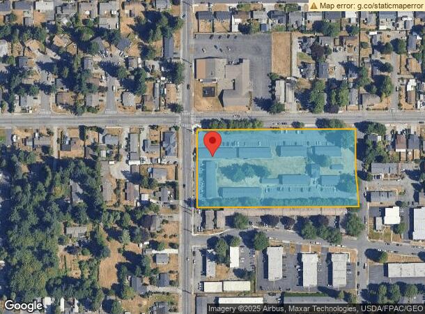
Property Record
2922 M St Se, Auburn, WA 98002

NEARBY LISTINGS FOR SALE OR LEASE
Property Detail
2922 M St Se
Seattle-Tacoma-Bellevue, WA
Daf - Beg Nw Cor Sd Subd
302105-9055
POR OF NW 1/4 OF SE 1/4 OF NE 1/4 DAF - BEG NW COR SD SUBD TH N 89- 15-53 E ALG N LN THOF TO NE COR SD SUBD TH S 0-03-28 E ALG E LN OF SD SUBD TO S LN OF N 1/2 OF SD SUBD TH S 89-17-38 W ALG SD S LN TO W LN OF SD SUBD TH N 0-09-28 W ALG SD W LN TO PO
Apartment
King
X
Washington
53033C1262G
302105
2025
4.19 AC
2024
South Auburn
030802
Seattle/Puget Sound
54,713 SF
DEMOGRAPHICS near 2922 M St Se
1 Mile
3 Mile
5 Mile
2024 Total Population
14,874
71,273
152,145
2029 Population
14,808
71,725
153,784
Pop Growth 2024-2029
(0.44%)
+ 0.63%
+ 1.08%
Average Age
37
38
39
2024 Total Households
5,091
25,351
53,007
HH Growth 2024-2029
(0.69%)
+ 0.54%
+ 0.99%
Median Household Inc
$61,389
$79,389
$89,157
Avg Household Size
2.80
2.70
2.80
2024 Avg HH Vehicles
2.00
2.00
2.00
Median Home Value
$221,656
$404,093
$465,696
Median Year Built
1977
1986
1988
Nearby Places
- Restaurants
- Banks
- Shops
- Fitness
- Groceries
PUBLIC TRANSPORTATION
COMMUTER RAIL
Auburn Station (Sounder South Line - Central Puget Sound Regional Transit Authority Rail (Link Light Rail/Sounder))
DRIVE
WALK
Distance
Auburn Station (Sounder South Line - Central Puget Sound Regional Transit Authority Rail (Link Light Rail/Sounder))
6 min
2.6 mi
Sumner Station (Sounder South Line - Central Puget Sound Regional Transit Authority Rail (Link Light Rail/Sounder))
DRIVE
WALK
Distance
Sumner Station (Sounder South Line - Central Puget Sound Regional Transit Authority Rail (Link Light Rail/Sounder))
16 min
9.7 mi
AIRPORT
Seattle-Tacoma International
DRIVE
WALK
Distance
Seattle-Tacoma International
30 min
16.2 mi
Freight Ports
Port of Tacoma
DRIVE
WALK
Distance
Port of Tacoma
23 min
14.3 mi
Nearby Properties
Address
Land Use
TOTAL SIZE
Lot Size
Zoning
Address
Land Use
TOTAL SIZE
Lot Size
Zoning
524,636 SF
102.28 AC
M2
Address
Land Use
TOTAL SIZE
Lot Size
Zoning
662,963 SF
29.75 AC
M2
Address
Land Use
TOTAL SIZE
Lot Size
Zoning
749,967 SF
39.82 AC
M2
Address
Land Use
TOTAL SIZE
Lot Size
Zoning
63,950 SF
127.86 AC
C3
Address
Land Use
TOTAL SIZE
Lot Size
Zoning
217,000 SF
19.99 AC
R20
Address
Land Use
TOTAL SIZE
Lot Size
Zoning
9,765 SF
87.33 AC
I
Address
Land Use
TOTAL SIZE
Lot Size
Zoning
923,143 SF
90.42 AC
C3
Address
Land Use
TOTAL SIZE
Lot Size
Zoning
501,104 SF
21.73 AC
Address
Land Use
TOTAL SIZE
Lot Size
Zoning
245,393 SF
2.48 AC
DUC
Address
Land Use
TOTAL SIZE
Lot Size
Zoning
251,498 SF
13.79 AC
LAKELAND H
Address
Land Use
TOTAL SIZE
Lot Size
Zoning
441,316 SF
20.26 AC
Address
Land Use
TOTAL SIZE
Lot Size
Zoning
288,600 SF
21.93 AC
M2
Address
Land Use
TOTAL SIZE
Lot Size
Zoning
287,945 SF
11.12 AC
M-1
Address
Land Use
TOTAL SIZE
Lot Size
Zoning
286,350 SF
13.84 AC
M1
Address
Land Use
TOTAL SIZE
Lot Size
Zoning
127,096 SF
12.48 AC
LAKELAND H
Address
Land Use
TOTAL SIZE
Lot Size
Zoning
215,619 SF
21.57 AC
TV
Address
Land Use
TOTAL SIZE
Lot Size
Zoning
278,038 SF
12.91 AC
M-1
Address
Land Use
TOTAL SIZE
Lot Size
Zoning
270,739 SF
12.20 AC
M-1
Address
Land Use
TOTAL SIZE
Lot Size
Zoning
160,432 SF
4.70 AC
C1
Address
Land Use
TOTAL SIZE
Lot Size
Zoning
204,727 SF
18.63 AC
TV
Address
Land Use
TOTAL SIZE
Lot Size
Zoning
333,180 SF
18.13 AC
Address
Land Use
TOTAL SIZE
Lot Size
Zoning
258,308 SF
10.55 AC
M2
Address
Land Use
TOTAL SIZE
Lot Size
Zoning
292,072 SF
12.62 AC
Address
Land Use
TOTAL SIZE
Lot Size
Zoning
205,443 SF
11.41 AC
M2
Address
Land Use
TOTAL SIZE
Lot Size
Zoning
218,316 SF
8.69 AC
M-1
Address
Land Use
TOTAL SIZE
Lot Size
Zoning
186,749 SF
6.14 AC
P1
Address
Land Use
TOTAL SIZE
Lot Size
Zoning
144,780 SF
9.54 AC
R20
Address
Land Use
TOTAL SIZE
Lot Size
Zoning
206,001 SF
10.69 AC
M-1
The World's #1 Commercial Real Estate Marketplace
Connect with us
© 2025 CoStar Group
The information above has been obtained from sources believed reliable. While we do not doubt its accuracy we have not verified it and make no guarantee, warranty or representation about it. It is your responsibility to independently confirm its accuracy and completeness. Any projections, opinions, assumptions, or estimates used are for example only and do not represent the current or future performance of the property. The value of this transaction to you depends on tax and other factors which should be evaluated by your tax, financial, and legal advisors. You and your advisors should conduct a careful, independent investigation of the property to determine to your satisfaction the suitability of the property for your needs.