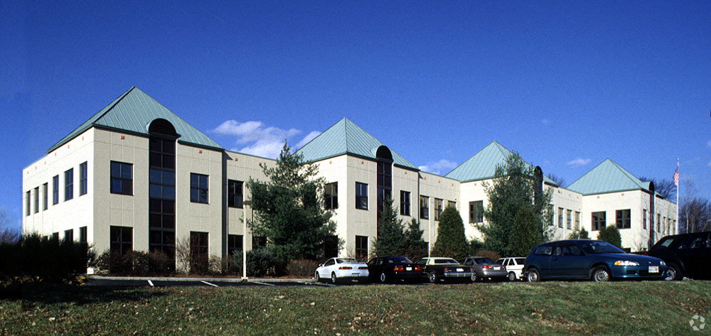
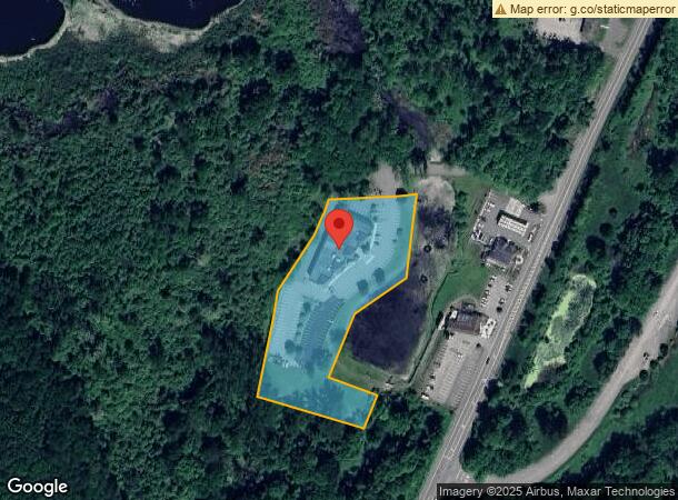
Property Record
293 Route 100, Somers, NY 10589
NEARBY LISTINGS FOR SALE OR LEASE
Property Detail
293 Route 100
5200-017-018-00001-000-0004
Westchester
Officebuilding
New York
AE
4.000
36119C0054F
3.28 AC
2023
North
2023
Westchester/So Connecticut
014901
New York-Jersey City-White Plains, NY-NJ
DEMOGRAPHICS near 293 Route 100
1 Mile
3 Mile
5 Mile
2024 Total Population
1,659
19,737
49,754
2029 Population
1,600
19,383
48,986
Pop Growth 2024-2029
(3.56%)
(1.79%)
(1.54%)
Average Age
55
49
45
2024 Total Households
740
7,942
18,468
HH Growth 2024-2029
(4.19%)
(1.67%)
(1.54%)
Median Household Inc
$124,106
$137,378
$142,288
Avg Household Size
2.10
2.40
2.60
2024 Avg HH Vehicles
2.00
2.00
2.00
Median Home Value
$499,999
$538,367
$556,790
Median Year Built
1975
1977
1973
Nearby Places
- Restaurants
- Banks
- Shops
- Fitness
- Groceries
PUBLIC TRANSPORTATION
COMMUTER RAIL
Golden's Bridge Station (Harlem Line - Metro-North Commuter Railroad Company (Metro-North))
DRIVE
WALK
Distance
Golden's Bridge Station (Harlem Line - Metro-North Commuter Railroad Company (Metro-North))
4 min
2.2 mi
Purdy's Station (Harlem Line - Metro-North Commuter Railroad Company (Metro-North))
DRIVE
WALK
Distance
Purdy's Station (Harlem Line - Metro-North Commuter Railroad Company (Metro-North))
6 min
2.5 mi
AIRPORT
Westchester County
DRIVE
WALK
Distance
Westchester County
26 min
19.2 mi
New York Stewart International
DRIVE
WALK
Distance
New York Stewart International
62 min
44.7 mi
Freight Ports
Port of New Haven
DRIVE
WALK
Distance
Port of New Haven
78 min
52.7 mi
SALE & LEASE HISTORY
LISTING DATE
SALE/LEASE

Aug 18, 2017
For Lease
Apr 17, 2017
For Lease
Nearby Properties
Address
Land Use
TOTAL SIZE
Lot Size
Zoning
Address
Land Use
TOTAL SIZE
Lot Size
Zoning
38.19 AC
Address
Land Use
TOTAL SIZE
Lot Size
Zoning
1,078,069 SF
723.08 AC
Address
Land Use
TOTAL SIZE
Lot Size
Zoning
447.03 AC
R-120
Address
Land Use
TOTAL SIZE
Lot Size
Zoning
Address
Land Use
TOTAL SIZE
Lot Size
Zoning
10 AC
Address
Land Use
TOTAL SIZE
Lot Size
Zoning
864 SF
4.77 AC
R
Address
Land Use
TOTAL SIZE
Lot Size
Zoning
Address
Land Use
TOTAL SIZE
Lot Size
Zoning
98.59 AC
Address
Land Use
TOTAL SIZE
Lot Size
Zoning
172.78 AC
Address
Land Use
TOTAL SIZE
Lot Size
Zoning
1,984 SF
17.90 AC
R-120
Address
Land Use
TOTAL SIZE
Lot Size
Zoning
120.59 AC
Address
Land Use
TOTAL SIZE
Lot Size
Zoning
30.81 AC
Address
Land Use
TOTAL SIZE
Lot Size
Zoning
114.82 AC
Address
Land Use
TOTAL SIZE
Lot Size
Zoning
19.11 AC
Address
Land Use
TOTAL SIZE
Lot Size
Zoning
93.51 AC
Address
Land Use
TOTAL SIZE
Lot Size
Zoning
11.80 AC
Address
Land Use
TOTAL SIZE
Lot Size
Zoning
2,431 SF
58.02 AC
R-80
Address
Land Use
TOTAL SIZE
Lot Size
Zoning
10.79 AC
NS
Address
Land Use
TOTAL SIZE
Lot Size
Zoning
30.01 AC
Address
Land Use
TOTAL SIZE
Lot Size
Zoning
9.06 AC
Address
Land Use
TOTAL SIZE
Lot Size
Zoning
1,795 SF
25.31 AC
R-120
Address
Land Use
TOTAL SIZE
Lot Size
Zoning
0.98 AC
Address
Land Use
TOTAL SIZE
Lot Size
Zoning
0.57 AC
Address
Land Use
TOTAL SIZE
Lot Size
Zoning
1.44 AC
Address
Land Use
TOTAL SIZE
Lot Size
Zoning
10,500 SF
0.50 AC
Address
Land Use
TOTAL SIZE
Lot Size
Zoning
1.65 AC
Address
Land Use
TOTAL SIZE
Lot Size
Zoning
2.64 AC
Address
Land Use
TOTAL SIZE
Lot Size
Zoning
13.03 AC
Address
Land Use
TOTAL SIZE
Lot Size
Zoning
1.40 AC
Address
Land Use
TOTAL SIZE
Lot Size
Zoning
68.53 AC
The World's #1 Commercial Real Estate Marketplace
Connect with us
© 2025 CoStar Group
The information above has been obtained from sources believed reliable. While we do not doubt its accuracy we have not verified it and make no guarantee, warranty or representation about it. It is your responsibility to independently confirm its accuracy and completeness. Any projections, opinions, assumptions, or estimates used are for example only and do not represent the current or future performance of the property. The value of this transaction to you depends on tax and other factors which should be evaluated by your tax, financial, and legal advisors. You and your advisors should conduct a careful, independent investigation of the property to determine to your satisfaction the suitability of the property for your needs.