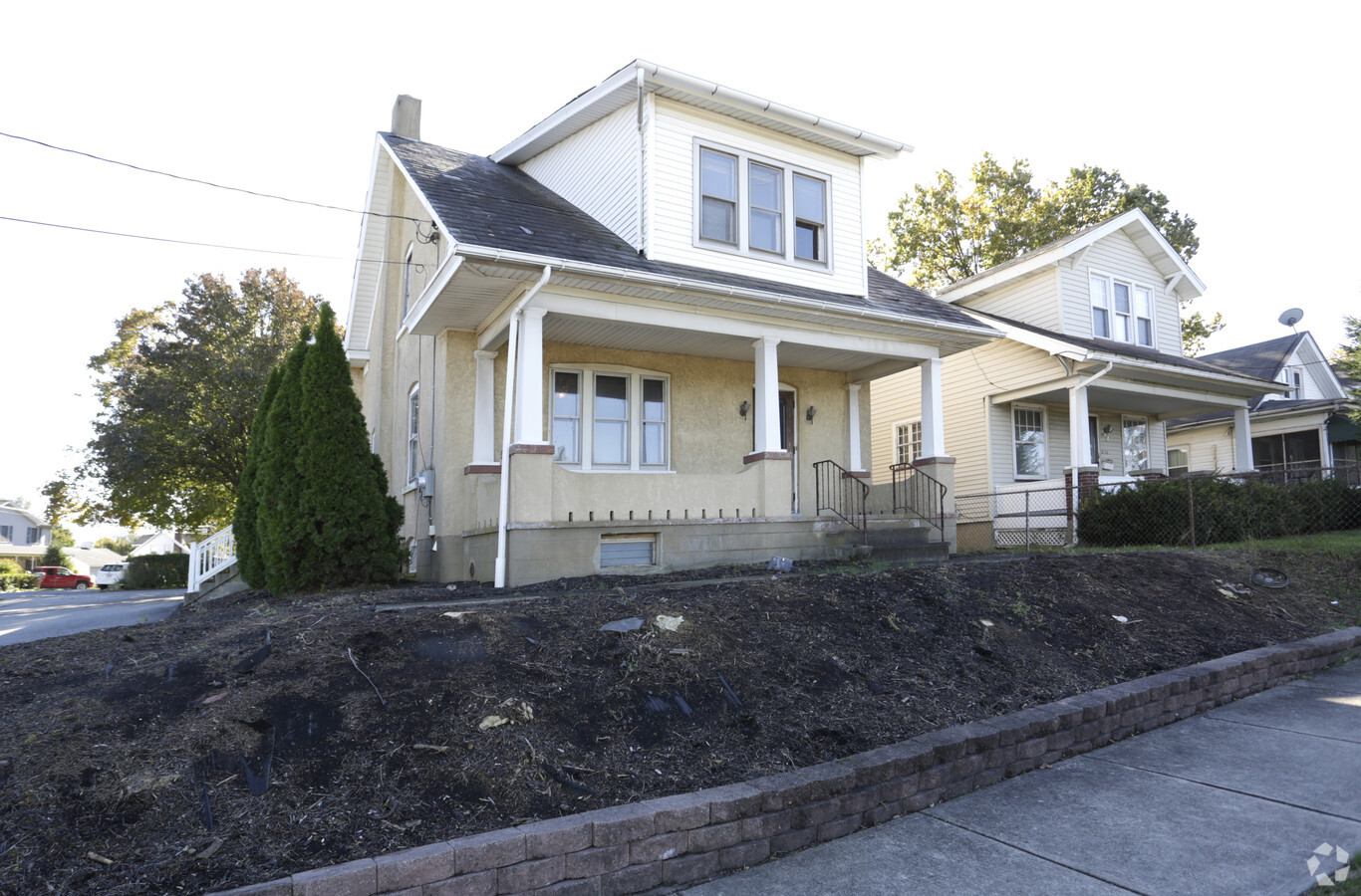
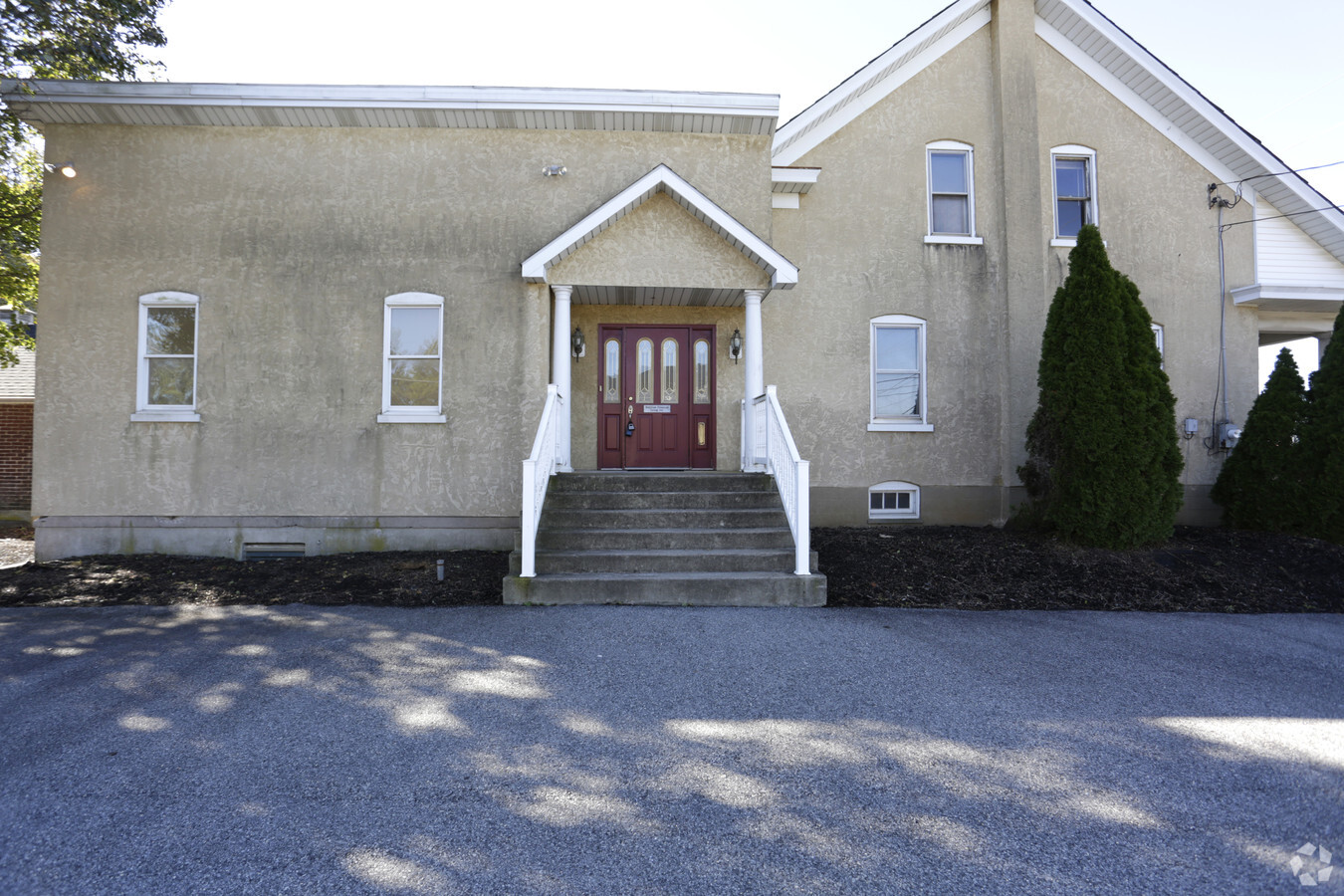
Property Record
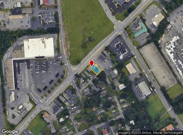
2950 William Penn Hwy, Easton, PA 18045
NEARBY LISTINGS FOR SALE OR LEASE
Property Detail
2950 William Penn Hwy
Officebuilding
Northampton
X
Pennsylvania
42095C0267E
0.16 AC
2024
Lehigh Valley
2024
Philadelphia
017501
Allentown-Bethlehem-Easton, PA-NJ
3,046 SF
M8NE2-5-5-0324
DEMOGRAPHICS near 2950 William Penn Hwy
1 Mile
3 Mile
5 Mile
2024 Total Population
11,038
67,928
142,085
2029 Population
11,060
68,253
143,384
Pop Growth 2024-2029
+ 0.20%
+ 0.48%
+ 0.91%
Average Age
43
41
41
2024 Total Households
4,441
25,782
53,524
HH Growth 2024-2029
+ 0.20%
+ 0.48%
+ 0.94%
Median Household Inc
$85,430
$80,904
$84,486
Avg Household Size
2.40
2.50
2.50
2024 Avg HH Vehicles
2.00
2.00
2.00
Median Home Value
$219,573
$242,782
$259,544
Median Year Built
1966
1963
1969
Nearby Places
- Restaurants
- Banks
- Shops
- Fitness
- Groceries
PUBLIC TRANSPORTATION
AIRPORT
Lehigh Valley International
DRIVE
WALK
Distance
Lehigh Valley International
21 min
13.0 mi
Freight Ports
Port of Philadelphia
DRIVE
WALK
Distance
Port of Philadelphia
97 min
60.0 mi
SALE & LEASE HISTORY
LISTING DATE
SALE/LEASE

Sep 01, 2017
For Sale
Oct 31, 2018
For Lease
May 31, 2019
For Sale
Aug 07, 2017
For Sale
Nearby Properties
Address
Land Use
TOTAL SIZE
Lot Size
Zoning
Address
Land Use
TOTAL SIZE
Lot Size
Zoning
87,508 SF
40.79 AC
CCE
Address
Land Use
TOTAL SIZE
Lot Size
Zoning
127,731 SF
56.29 AC
R12
Address
Land Use
TOTAL SIZE
Lot Size
Zoning
148,804 SF
22.75 AC
OB
Address
Land Use
TOTAL SIZE
Lot Size
Zoning
84,805 SF
12.20 AC
CHDD
Address
Land Use
TOTAL SIZE
Lot Size
Zoning
56,276 SF
14.91 AC
RR
Address
Land Use
TOTAL SIZE
Lot Size
Zoning
4,913 SF
27.03 AC
PIC
Address
Land Use
TOTAL SIZE
Lot Size
Zoning
176,397 SF
45.38 AC
HI
Address
Land Use
TOTAL SIZE
Lot Size
Zoning
26,714 SF
33.71 AC
RI
Address
Land Use
TOTAL SIZE
Lot Size
Zoning
430,201 SF
17.30 AC
I
Address
Land Use
TOTAL SIZE
Lot Size
Zoning
27,160 SF
16.26 AC
HDR
Address
Land Use
TOTAL SIZE
Lot Size
Zoning
56,276 SF
6.94 AC
RR
Address
Land Use
TOTAL SIZE
Lot Size
Zoning
111,271 SF
15.32 AC
C
Address
Land Use
TOTAL SIZE
Lot Size
Zoning
135,293 SF
38 AC
C
Address
Land Use
TOTAL SIZE
Lot Size
Zoning
107,028 SF
3.31 AC
R2
Address
Land Use
TOTAL SIZE
Lot Size
Zoning
319,578 SF
27.91 AC
I
Address
Land Use
TOTAL SIZE
Lot Size
Zoning
137,060 SF
16.16 AC
OB
Address
Land Use
TOTAL SIZE
Lot Size
Zoning
3,055 SF
7.06 AC
OB
Address
Land Use
TOTAL SIZE
Lot Size
Zoning
131,739 SF
4.74 AC
OB
Address
Land Use
TOTAL SIZE
Lot Size
Zoning
59,583 SF
3.87 AC
C
Address
Land Use
TOTAL SIZE
Lot Size
Zoning
35,575 SF
35.21 AC
C
Address
Land Use
TOTAL SIZE
Lot Size
Zoning
73,506 SF
6.32 AC
OB
Address
Land Use
TOTAL SIZE
Lot Size
Zoning
75,460 SF
10.50 AC
OB
Address
Land Use
TOTAL SIZE
Lot Size
Zoning
56,276 SF
4.91 AC
RR
Address
Land Use
TOTAL SIZE
Lot Size
Zoning
43,122 SF
2.35 AC
RDD
Address
Land Use
TOTAL SIZE
Lot Size
Zoning
94,967 SF
29.12 AC
HI
Address
Land Use
TOTAL SIZE
Lot Size
Zoning
77,178 SF
16.19 AC
GC
Address
Land Use
TOTAL SIZE
Lot Size
Zoning
39,772 SF
6.02 AC
CR
Address
Land Use
TOTAL SIZE
Lot Size
Zoning
183,401 SF
10.71 AC
OB
Address
Land Use
TOTAL SIZE
Lot Size
Zoning
87,000 SF
8.05 AC
MHDR
Address
Land Use
TOTAL SIZE
Lot Size
Zoning
73,622 SF
10.67 AC
RR
The World's #1 Commercial Real Estate Marketplace
Connect with us
© 2025 CoStar Group
The information above has been obtained from sources believed reliable. While we do not doubt its accuracy we have not verified it and make no guarantee, warranty or representation about it. It is your responsibility to independently confirm its accuracy and completeness. Any projections, opinions, assumptions, or estimates used are for example only and do not represent the current or future performance of the property. The value of this transaction to you depends on tax and other factors which should be evaluated by your tax, financial, and legal advisors. You and your advisors should conduct a careful, independent investigation of the property to determine to your satisfaction the suitability of the property for your needs.