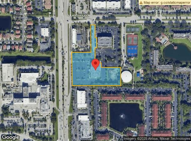
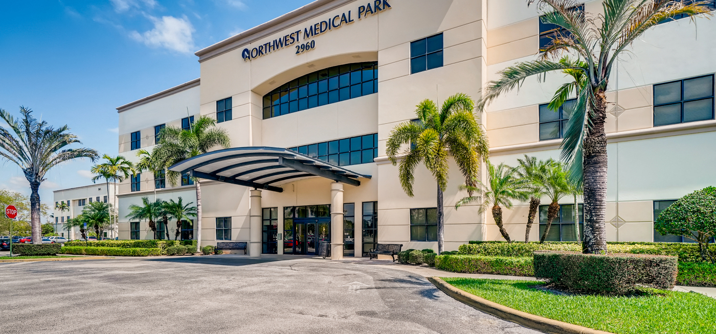
Property Record
2960 N State Road 7, Margate, FL 33063

Current Lease Availabilities
NEARBY LISTINGS FOR SALE OR LEASE
Property Detail
2960 N State Road 7
48-42-19-26-0020
Platts Plat 138-48 B
Medicalbuilding
PLATTS PLAT 138-48 B PORTION PARCEL A DESC AS COMM AT MOST NLY NW COR PAR A,E 178.78 TO POB,E 50.54,S 141.50,E 19,S 114.50,W 19,S 167.79,E 67.27,S 49.91,E 220.61,S 201.40,W 544.80 N 370.05,E 214.25,N 305 TO POB AKA: PARCEL 1
X
Broward
12099C1175F
Florida
2024
4 AC
2025
Pompano Beach
020101
South Florida
46,476 SF
Fort Lauderdale-Pompano Beach-Deerfield Beach, FL
DEMOGRAPHICS near 2960 N State Road 7
1 Mile
3 Mile
5 Mile
2024 Total Population
18,440
143,688
384,996
2029 Population
18,110
142,891
382,649
Pop Growth 2024-2029
(1.79%)
(0.55%)
(0.61%)
Average Age
40
42
40
2024 Total Households
7,285
55,703
143,528
HH Growth 2024-2029
(2.47%)
(0.85%)
(0.81%)
Median Household Inc
$59,215
$64,541
$62,888
Avg Household Size
2.40
2.50
2.60
2024 Avg HH Vehicles
2.00
2.00
2.00
Median Home Value
$291,158
$290,305
$291,469
Median Year Built
1985
1983
1982
Nearby Places
- Restaurants
- Banks
- Shops
- Fitness
- Groceries
PUBLIC TRANSPORTATION
COMMUTER RAIL
Pompano Beach (Tri-County Commuter - South Florida Regional Transportation Authority (Tri-Rail))
DRIVE
WALK
Distance
Pompano Beach (Tri-County Commuter - South Florida Regional Transportation Authority (Tri-Rail))
11 min
5.2 mi
Cypress Creek (Tri-County Commuter - South Florida Regional Transportation Authority (Tri-Rail))
DRIVE
WALK
Distance
Cypress Creek (Tri-County Commuter - South Florida Regional Transportation Authority (Tri-Rail))
16 min
8.0 mi
AIRPORT
Fort Lauderdale/Hollywood International
DRIVE
WALK
Distance
Fort Lauderdale/Hollywood International
32 min
20.7 mi
Palm Beach International
DRIVE
WALK
Distance
Palm Beach International
48 min
36.0 mi
Freight Ports
Port Everglades
DRIVE
WALK
Distance
Port Everglades
31 min
19.4 mi
Nearby Properties
Address
Land Use
TOTAL SIZE
Lot Size
Zoning
Address
Land Use
TOTAL SIZE
Lot Size
Zoning
425,379 SF
26.84 AC
RPUD
Address
Land Use
TOTAL SIZE
Lot Size
Zoning
32,538 SF
331.51 AC
P
Address
Land Use
TOTAL SIZE
Lot Size
Zoning
641,010 SF
29.99 AC
RM-20
Address
Land Use
TOTAL SIZE
Lot Size
Zoning
405,715 SF
20.11 AC
PUD
Address
Land Use
TOTAL SIZE
Lot Size
Zoning
399,296 SF
20.23 AC
RM-40
Address
Land Use
TOTAL SIZE
Lot Size
Zoning
451,337 SF
33.01 AC
R-3A
Address
Land Use
TOTAL SIZE
Lot Size
Zoning
356,704 SF
11.84 AC
PCD
Address
Land Use
TOTAL SIZE
Lot Size
Zoning
294,865 SF
14.49 AC
PUD
Address
Land Use
TOTAL SIZE
Lot Size
Zoning
649,284 SF
62.54 AC
CF
Address
Land Use
TOTAL SIZE
Lot Size
Zoning
423,291 SF
25.66 AC
RM-10
Address
Land Use
TOTAL SIZE
Lot Size
Zoning
500,974 SF
16.20 AC
CF-1
Address
Land Use
TOTAL SIZE
Lot Size
Zoning
276,412 SF
10.40 AC
TOC-G
Address
Land Use
TOTAL SIZE
Lot Size
Zoning
390,795 SF
16.83 AC
PUD
Address
Land Use
TOTAL SIZE
Lot Size
Zoning
354,535 SF
33.95 AC
RM-15
Address
Land Use
TOTAL SIZE
Lot Size
Zoning
311,680 SF
15.84 AC
PUD
Address
Land Use
TOTAL SIZE
Lot Size
Zoning
278,336 SF
15.85 AC
RM-20
Address
Land Use
TOTAL SIZE
Lot Size
Zoning
548,682 SF
21.63 AC
CF
Address
Land Use
TOTAL SIZE
Lot Size
Zoning
295,883 SF
21.22 AC
PUD
Address
Land Use
TOTAL SIZE
Lot Size
Zoning
274,772 SF
22.37 AC
PUD
Address
Land Use
TOTAL SIZE
Lot Size
Zoning
238,895 SF
13.84 AC
TOC-CC
Address
Land Use
TOTAL SIZE
Lot Size
Zoning
325,343 SF
21.10 AC
PUD
Address
Land Use
TOTAL SIZE
Lot Size
Zoning
216,533 SF
9.99 AC
RPUD
Address
Land Use
TOTAL SIZE
Lot Size
Zoning
384,131 SF
17.84 AC
PMDD
Address
Land Use
TOTAL SIZE
Lot Size
Zoning
311,836 SF
13.92 AC
RM-30
Address
Land Use
TOTAL SIZE
Lot Size
Zoning
291,908 SF
29.79 AC
B-3
Address
Land Use
TOTAL SIZE
Lot Size
Zoning
275,724 SF
26.67 AC
TOC-G
Address
Land Use
TOTAL SIZE
Lot Size
Zoning
269,508 SF
38.46 AC
A-1
Address
Land Use
TOTAL SIZE
Lot Size
Zoning
254,235 SF
25.40 AC
RM-10
Address
Land Use
TOTAL SIZE
Lot Size
Zoning
242,692 SF
17.25 AC
RM-20
Address
Land Use
TOTAL SIZE
Lot Size
Zoning
935,349 SF
20.20 AC
PMDD
The World's #1 Commercial Real Estate Marketplace
Connect with us
© 2025 CoStar Group
The information above has been obtained from sources believed reliable. While we do not doubt its accuracy we have not verified it and make no guarantee, warranty or representation about it. It is your responsibility to independently confirm its accuracy and completeness. Any projections, opinions, assumptions, or estimates used are for example only and do not represent the current or future performance of the property. The value of this transaction to you depends on tax and other factors which should be evaluated by your tax, financial, and legal advisors. You and your advisors should conduct a careful, independent investigation of the property to determine to your satisfaction the suitability of the property for your needs.