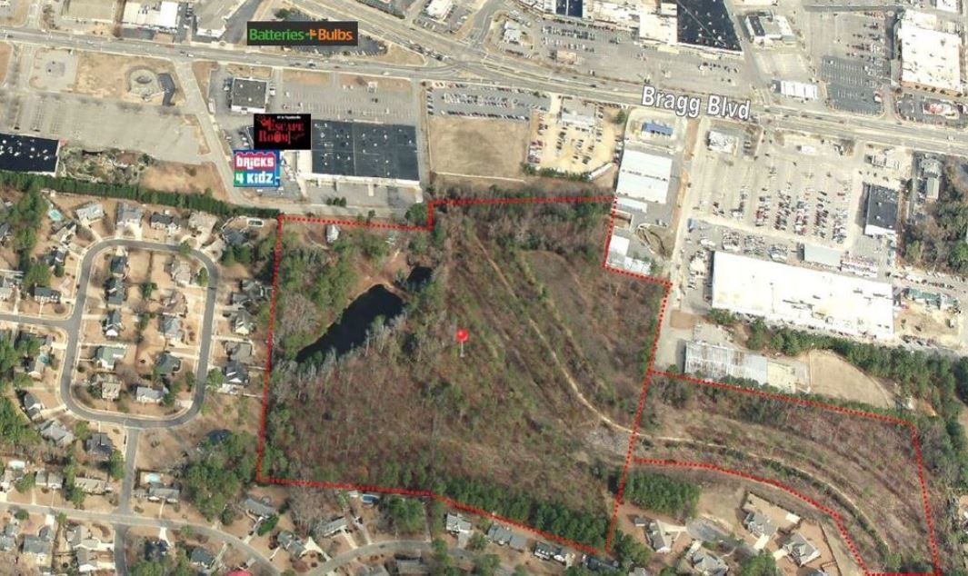
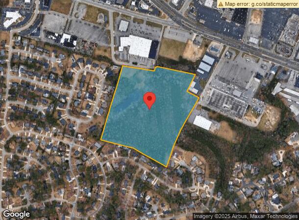
Property Record
2968 Damascus Rd, Fayetteville, NC 28303
This Property Is For Sale
NEARBY LISTINGS FOR SALE OR LEASE
Property Detail
2968 Damascus Rd
Fayetteville, NC
Howard Acres I
0418-72-7186
LINE REV MAP HOWARD & ADDISON SE:01 PL:0109-0018
Residentialacreage
Cumberland
X
North Carolina
3720041800J
7186
2024
23.09 AC
2024
North Fayetteville
002100
Fayetteville
936 SF
DEMOGRAPHICS near 2968 Damascus Rd
1 Mile
3 Mile
5 Mile
2024 Total Population
5,287
60,446
148,377
2029 Population
5,249
60,672
148,745
Pop Growth 2024-2029
(0.72%)
+ 0.37%
+ 0.25%
Average Age
37
38
37
2024 Total Households
2,367
26,676
61,745
HH Growth 2024-2029
(0.51%)
+ 0.40%
+ 0.27%
Median Household Inc
$39,777
$47,763
$46,969
Avg Household Size
2.20
2.10
2.20
2024 Avg HH Vehicles
1.00
2.00
2.00
Median Home Value
$258,892
$155,793
$145,167
Median Year Built
1975
1975
1978
Nearby Places
- Restaurants
- Banks
- Shops
- Fitness
- Groceries
PUBLIC TRANSPORTATION
COMMUTER RAIL
Fayetteville Amtrak Station (Palmetto - Amtrak, Silver Meteor - Amtrak)
DRIVE
WALK
Distance
Fayetteville Amtrak Station (Palmetto - Amtrak, Silver Meteor - Amtrak)
8 min
4.0 mi
AIRPORT
Fayetteville Regional/Grannis Field
DRIVE
WALK
Distance
Fayetteville Regional/Grannis Field
16 min
9.3 mi
Freight Ports
Port of Wilmington
DRIVE
WALK
Distance
Port of Wilmington
133 min
95.0 mi
Nearby Properties
Address
Land Use
TOTAL SIZE
Lot Size
Zoning
Address
Land Use
TOTAL SIZE
Lot Size
Zoning
182,282 SF
38.72 AC
OI
Address
Land Use
TOTAL SIZE
Lot Size
Zoning
2,193 SF
133.52 AC
MR5
Address
Land Use
TOTAL SIZE
Lot Size
Zoning
82.54 AC
BPCZ-BUSI
Address
Land Use
TOTAL SIZE
Lot Size
Zoning
3,641 SF
20.54 AC
MR5
Address
Land Use
TOTAL SIZE
Lot Size
Zoning
2,744 SF
21.34 AC
MR5
Address
Land Use
TOTAL SIZE
Lot Size
Zoning
3,320 SF
16 AC
MR5
Address
Land Use
TOTAL SIZE
Lot Size
Zoning
5,755 SF
23.12 AC
CC-COMMUNI
Address
Land Use
TOTAL SIZE
Lot Size
Zoning
2,842 SF
23.27 AC
MR5
Address
Land Use
TOTAL SIZE
Lot Size
Zoning
2,025 SF
27.17 AC
SF6
Address
Land Use
TOTAL SIZE
Lot Size
Zoning
1,556 SF
15.80 AC
MR5
Address
Land Use
TOTAL SIZE
Lot Size
Zoning
3,999 SF
44.59 AC
MR5
Address
Land Use
TOTAL SIZE
Lot Size
Zoning
19.46 AC
MR5
Address
Land Use
TOTAL SIZE
Lot Size
Zoning
54,316 SF
28.64 AC
CC
Address
Land Use
TOTAL SIZE
Lot Size
Zoning
4,522 SF
12.59 AC
MR5
Address
Land Use
TOTAL SIZE
Lot Size
Zoning
5,112 SF
28.44 AC
CC-COMMUNI
Address
Land Use
TOTAL SIZE
Lot Size
Zoning
1,352 SF
43.38 AC
MR5
Address
Land Use
TOTAL SIZE
Lot Size
Zoning
13.94 AC
CCCZ
Address
Land Use
TOTAL SIZE
Lot Size
Zoning
2,314 SF
21.82 AC
MR5
Address
Land Use
TOTAL SIZE
Lot Size
Zoning
1,064 SF
9.88 AC
R5C
Address
Land Use
TOTAL SIZE
Lot Size
Zoning
58,704 SF
23.38 AC
CC
Address
Land Use
TOTAL SIZE
Lot Size
Zoning
181,147 SF
24.02 AC
CCCZ
Address
Land Use
TOTAL SIZE
Lot Size
Zoning
1,039 SF
13.65 AC
MR5
Address
Land Use
TOTAL SIZE
Lot Size
Zoning
135,996 SF
14.28 AC
CCCZ
Address
Land Use
TOTAL SIZE
Lot Size
Zoning
2,529 SF
5.95 AC
MR5
Address
Land Use
TOTAL SIZE
Lot Size
Zoning
1,682 SF
30.53 AC
CC-COMMUNI
Address
Land Use
TOTAL SIZE
Lot Size
Zoning
1,732 SF
13.45 AC
MR5
Address
Land Use
TOTAL SIZE
Lot Size
Zoning
2,797 SF
54.38 AC
(UC) UNIVE
Address
Land Use
TOTAL SIZE
Lot Size
Zoning
48,716 SF
57.88 AC
SF10
Address
Land Use
TOTAL SIZE
Lot Size
Zoning
3,840 SF
17.54 AC
UK-UNKNOWN
Address
Land Use
TOTAL SIZE
Lot Size
Zoning
10,158 SF
11.49 AC
SF6
The World's #1 Commercial Real Estate Marketplace
Connect with us
© 2025 CoStar Group
The information above has been obtained from sources believed reliable. While we do not doubt its accuracy we have not verified it and make no guarantee, warranty or representation about it. It is your responsibility to independently confirm its accuracy and completeness. Any projections, opinions, assumptions, or estimates used are for example only and do not represent the current or future performance of the property. The value of this transaction to you depends on tax and other factors which should be evaluated by your tax, financial, and legal advisors. You and your advisors should conduct a careful, independent investigation of the property to determine to your satisfaction the suitability of the property for your needs.