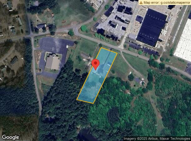
Property Record
2969 Nazareth Rd, Wellford, SC 29385
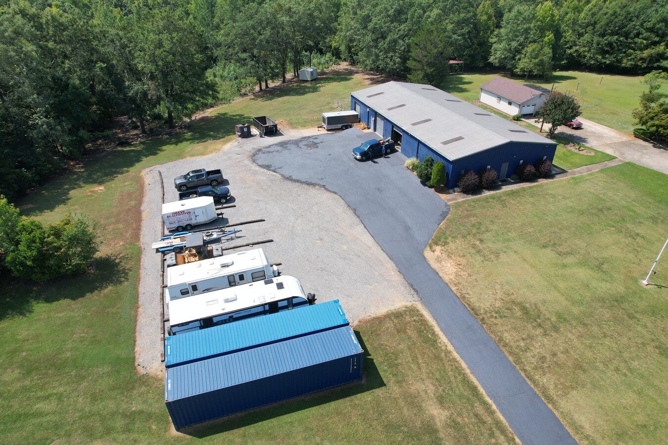
This Property Is For Sale
NEARBY LISTINGS FOR SALE OR LEASE
Property Detail
2969 Nazareth Rd
Spartanburg, SC
Charles S Cox And Eleanor H Cox
5-21-00-010.06
PO LT 1 ELEANOR H COX & JANICE H ROBERTSON PB 133-497
Publicstorage
Spartanburg
X
South Carolina
45083C0237D
1
2024
2.33 AC
2023
Upper Spartanburg Cty
023104
Greenville/Spartanburg
5,000 SF
DEMOGRAPHICS near 2969 Nazareth Rd
1 Mile
3 Mile
5 Mile
2024 Total Population
1,426
18,583
61,427
2029 Population
1,573
21,135
69,742
Pop Growth 2024-2029
+ 10.31%
+ 13.73%
+ 13.54%
Average Age
37
37
38
2024 Total Households
548
7,306
23,161
HH Growth 2024-2029
+ 10.58%
+ 13.95%
+ 13.78%
Median Household Inc
$44,110
$58,593
$70,424
Avg Household Size
2.50
2.50
2.60
2024 Avg HH Vehicles
2.00
2.00
2.00
Median Home Value
$99,440
$178,367
$232,956
Median Year Built
1976
1991
1997
Nearby Places
- Restaurants
- Banks
- Shops
- Fitness
- Groceries
PUBLIC TRANSPORTATION
COMMUTER RAIL
Spartanburg Amtrak Station (Crescent - Amtrak)
DRIVE
WALK
Distance
Spartanburg Amtrak Station (Crescent - Amtrak)
18 min
9.6 mi
AIRPORT
Greenville Spartanburg International
DRIVE
WALK
Distance
Greenville Spartanburg International
19 min
11.6 mi
Freight Ports
North Charleston Terminal
DRIVE
WALK
Distance
North Charleston Terminal
224 min
198.2 mi
Nearby Properties
Address
Land Use
TOTAL SIZE
Lot Size
Zoning
Address
Land Use
TOTAL SIZE
Lot Size
Zoning
873,910 SF
31.46 AC
Address
Land Use
TOTAL SIZE
Lot Size
Zoning
318,450 SF
22.63 AC
Address
Land Use
TOTAL SIZE
Lot Size
Zoning
303,442 SF
21.23 AC
Address
Land Use
TOTAL SIZE
Lot Size
Zoning
185,745 SF
14.17 AC
Address
Land Use
TOTAL SIZE
Lot Size
Zoning
2,528 SF
14.74 AC
Address
Land Use
TOTAL SIZE
Lot Size
Zoning
417,082 SF
10 AC
Address
Land Use
TOTAL SIZE
Lot Size
Zoning
286,000 SF
29.26 AC
Address
Land Use
TOTAL SIZE
Lot Size
Zoning
21,600 SF
19.85 AC
Address
Land Use
TOTAL SIZE
Lot Size
Zoning
2,200 SF
21.12 AC
Address
Land Use
TOTAL SIZE
Lot Size
Zoning
11,904 SF
3.90 AC
Address
Land Use
TOTAL SIZE
Lot Size
Zoning
402,619 SF
58.63 AC
Address
Land Use
TOTAL SIZE
Lot Size
Zoning
12,534 SF
41.56 AC
Address
Land Use
TOTAL SIZE
Lot Size
Zoning
1,964,569 SF
46.64 AC
Address
Land Use
TOTAL SIZE
Lot Size
Zoning
28.26 AC
Address
Land Use
TOTAL SIZE
Lot Size
Zoning
67,938 SF
8.02 AC
Address
Land Use
TOTAL SIZE
Lot Size
Zoning
10,000 SF
14.36 AC
Address
Land Use
TOTAL SIZE
Lot Size
Zoning
60,668 SF
8.02 AC
Address
Land Use
TOTAL SIZE
Lot Size
Zoning
25,794 SF
13.72 AC
Address
Land Use
TOTAL SIZE
Lot Size
Zoning
107.32 AC
Address
Land Use
TOTAL SIZE
Lot Size
Zoning
851,634 SF
15.68 AC
Address
Land Use
TOTAL SIZE
Lot Size
Zoning
10,756 SF
3.42 AC
Address
Land Use
TOTAL SIZE
Lot Size
Zoning
139,404 SF
9.83 AC
Address
Land Use
TOTAL SIZE
Lot Size
Zoning
213,000 SF
17.79 AC
Address
Land Use
TOTAL SIZE
Lot Size
Zoning
273,000 SF
20.76 AC
Address
Land Use
TOTAL SIZE
Lot Size
Zoning
242,400 SF
10.30 AC
Address
Land Use
TOTAL SIZE
Lot Size
Zoning
514,066 SF
10.44 AC
Address
Land Use
TOTAL SIZE
Lot Size
Zoning
98,339 SF
8.62 AC
Address
Land Use
TOTAL SIZE
Lot Size
Zoning
94,850 SF
6.50 AC
Address
Land Use
TOTAL SIZE
Lot Size
Zoning
223,832 SF
31.43 AC
Address
Land Use
TOTAL SIZE
Lot Size
Zoning
393,732 SF
11.88 AC
The World's #1 Commercial Real Estate Marketplace
Connect with us
© 2025 CoStar Group
The information above has been obtained from sources believed reliable. While we do not doubt its accuracy we have not verified it and make no guarantee, warranty or representation about it. It is your responsibility to independently confirm its accuracy and completeness. Any projections, opinions, assumptions, or estimates used are for example only and do not represent the current or future performance of the property. The value of this transaction to you depends on tax and other factors which should be evaluated by your tax, financial, and legal advisors. You and your advisors should conduct a careful, independent investigation of the property to determine to your satisfaction the suitability of the property for your needs.