Property Record
29945 Wesley Chapel Blvd, Wesley Chapel, FL 33543
NEARBY LISTINGS FOR SALE OR LEASE
Property Detail
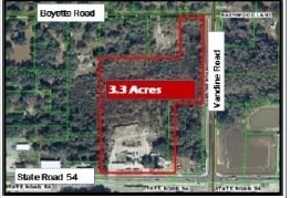
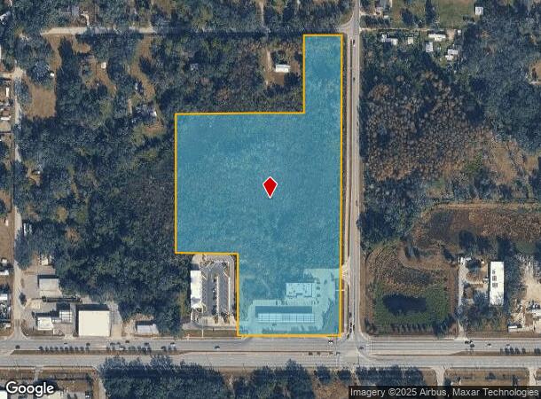
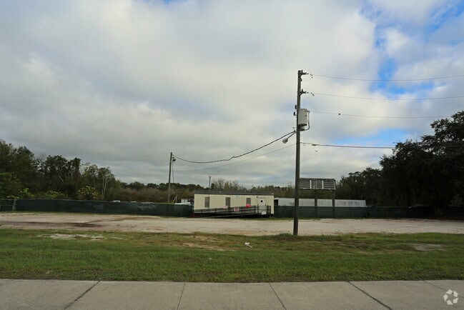
29945 Wesley Chapel Blvd
08-26-20-0000-00500-0000
COM AT NE COR OF NE 1/4 OF SEC 8 TH S0DEG3015W 1188.31 FT TH N89DEG4637W 60 FT TO POB TH N89DEG4637W 398.34 FT TH N0DEG0722E 315.17 FT TH N 89DEG2950W 238.33 FT TH N0 DEG2817E 541.48 FT TH N89 DEG4632E 498.1 FT TH N0DEG 3015E 300.02 FT TH N89DEG46 32
Storebuilding
Pasco
AE
Florida
12101C0427F
12.03 AC
2024
Pasco County
2026
Tampa/St Petersburg
032104
Tampa-St. Petersburg-Clearwater, FL
5,600 SF
DEMOGRAPHICS near 29945 Wesley Chapel Blvd
1 Mile
3 Mile
5 Mile
2024 Total Population
4,803
41,127
104,590
2029 Population
5,871
50,321
127,382
Pop Growth 2024-2029
+ 22.24%
+ 22.36%
+ 21.79%
Average Age
39
37
38
2024 Total Households
1,670
13,628
36,501
HH Growth 2024-2029
+ 22.22%
+ 22.31%
+ 21.69%
Median Household Inc
$96,127
$104,142
$99,061
Avg Household Size
2.80
2.90
2.80
2024 Avg HH Vehicles
3.00
2.00
2.00
Median Home Value
$299,575
$308,071
$308,829
Median Year Built
2001
2007
2006
Nearby Places
Map Layers
Map Styles
 Street
 Aerial
- Restaurants
- Banks
- Shops
- Fitness
- Groceries
PUBLIC TRANSPORTATION
AIRPORT
Tampa International
DRIVE
WALK
Distance
Tampa International
43 min
31.6 mi
Freight Ports
Port of Tampa Bay
DRIVE
WALK
Distance
Port of Tampa Bay
39 min
27.2 mi
SALE & LEASE HISTORY
LISTING DATE
SALE/LEASE

Sep 24, 2016
For Sale
Nearby Properties
Address
Land Use
TOTAL SIZE
Lot Size
Zoning
Address
Land Use
TOTAL SIZE
Lot Size
Zoning
435,775 SF
138.45 AC
AR
Address
Land Use
TOTAL SIZE
Lot Size
Zoning
306,559 SF
34.59 AC
MPUD
Address
Land Use
TOTAL SIZE
Lot Size
Zoning
343,155 SF
23.92 AC
MPUD
Address
Land Use
TOTAL SIZE
Lot Size
Zoning
398,092 SF
22.48 AC
MPUD
Address
Land Use
TOTAL SIZE
Lot Size
Zoning
319,575 SF
19.80 AC
MPUD
Address
Land Use
TOTAL SIZE
Lot Size
Zoning
315,343 SF
20.80 AC
MPUD
Address
Land Use
TOTAL SIZE
Lot Size
Zoning
275,549 SF
16.24 AC
C2
Address
Land Use
TOTAL SIZE
Lot Size
Zoning
418,644 SF
105.51 AC
AR
Address
Land Use
TOTAL SIZE
Lot Size
Zoning
287,834 SF
14.40 AC
MPUD
Address
Land Use
TOTAL SIZE
Lot Size
Zoning
241,371 SF
11.48 AC
MPUD
Address
Land Use
TOTAL SIZE
Lot Size
Zoning
50,016 SF
14.04 AC
MPUD
Address
Land Use
TOTAL SIZE
Lot Size
Zoning
244,355 SF
70.12 AC
MPUD
Address
Land Use
TOTAL SIZE
Lot Size
Zoning
153,412 SF
9.77 AC
MPUD
Address
Land Use
TOTAL SIZE
Lot Size
Zoning
146,401 SF
17.78 AC
MPUD
Address
Land Use
TOTAL SIZE
Lot Size
Zoning
142,552 SF
5.69 AC
MPUD
Address
Land Use
TOTAL SIZE
Lot Size
Zoning
115,596 SF
3.83 AC
C2
Address
Land Use
TOTAL SIZE
Lot Size
Zoning
28,631 SF
8.84 AC
MPUD
Address
Land Use
TOTAL SIZE
Lot Size
Zoning
109,440 SF
3.28 AC
C2
Address
Land Use
TOTAL SIZE
Lot Size
Zoning
189,610 SF
13.68 AC
MPUD
Address
Land Use
TOTAL SIZE
Lot Size
Zoning
38,392 SF
9.54 AC
MPUD
Address
Land Use
TOTAL SIZE
Lot Size
Zoning
6.13 AC
MPUD
Address
Land Use
TOTAL SIZE
Lot Size
Zoning
210,354 SF
29.03 AC
C2
Address
Land Use
TOTAL SIZE
Lot Size
Zoning
90,759 SF
4.29 AC
MPUD
Address
Land Use
TOTAL SIZE
Lot Size
Zoning
93,933 SF
3.63 AC
C2
Address
Land Use
TOTAL SIZE
Lot Size
Zoning
46.78 AC
MPUD
Address
Land Use
TOTAL SIZE
Lot Size
Zoning
90,404 SF
17.90 AC
MPUD
Address
Land Use
TOTAL SIZE
Lot Size
Zoning
118,441 SF
14.20 AC
C2
Address
Land Use
TOTAL SIZE
Lot Size
Zoning
16.81 AC
MPUD
Address
Land Use
TOTAL SIZE
Lot Size
Zoning
235,286 SF
15.11 AC
MF2
Address
Land Use
TOTAL SIZE
Lot Size
Zoning
91,050 SF
4.18 AC
C2
The World's #1 Commercial Real Estate Marketplace
Connect with us
© 2026 CoStar Group
The information above has been obtained from sources believed reliable. While we do not doubt its accuracy we have not verified it and make no guarantee, warranty or representation about it. It is your responsibility to independently confirm its accuracy and completeness. Any projections, opinions, assumptions, or estimates used are for example only and do not represent the current or future performance of the property. The value of this transaction to you depends on tax and other factors which should be evaluated by your tax, financial, and legal advisors. You and your advisors should conduct a careful, independent investigation of the property to determine to your satisfaction the suitability of the property for your needs.