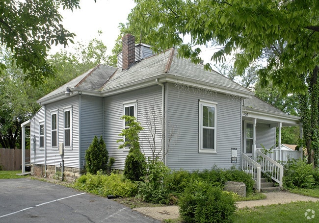
Property Record
300 Main St, Saint Peters, MO 63376


NEARBY LISTINGS FOR SALE OR LEASE
Property Detail
300 Main St
St. Louis, MO-IL
Brookmount Estate 12
2-055D-0762-00-0003.0000000
PT SUR 762
Commercialnec
St. Charles
X
Missouri
29183C0261G
3
2024
0.25 AC
2025
St Charles County
311500
St. Louis
1,406 SF
DEMOGRAPHICS near 300 Main St
1 Mile
3 Mile
5 Mile
2024 Total Population
5,414
52,890
149,051
2029 Population
5,723
55,841
157,201
Pop Growth 2024-2029
+ 5.71%
+ 5.58%
+ 5.47%
Average Age
42
42
41
2024 Total Households
2,358
20,627
58,444
HH Growth 2024-2029
+ 5.77%
+ 5.72%
+ 5.58%
Median Household Inc
$55,729
$87,496
$88,609
Avg Household Size
2.20
2.50
2.50
2024 Avg HH Vehicles
2.00
2.00
2.00
Median Home Value
$154,012
$238,582
$254,438
Median Year Built
1975
1987
1988
Nearby Places
Map Layers
Map Styles
 Street
 Aerial
- Restaurants
- Banks
- Shops
- Fitness
- Groceries
PUBLIC TRANSPORTATION
AIRPORT
St Louis Lambert International
DRIVE
WALK
Distance
St Louis Lambert International
26 min
17.8 mi
SALE & LEASE HISTORY
LISTING DATE
SALE/LEASE

Sep 23, 2016
For Sale
Jul 13, 2018
For Sale
Nearby Properties
Address
Land Use
TOTAL SIZE
Lot Size
Zoning
Address
Land Use
TOTAL SIZE
Lot Size
Zoning
500,420 SF
99.80 AC
Address
Land Use
TOTAL SIZE
Lot Size
Zoning
810,640 SF
48.73 AC
Address
Land Use
TOTAL SIZE
Lot Size
Zoning
423,000 SF
18.07 AC
Address
Land Use
TOTAL SIZE
Lot Size
Zoning
136,142 SF
31.16 AC
Address
Land Use
TOTAL SIZE
Lot Size
Zoning
189,054 SF
24.92 AC
AA1
Address
Land Use
TOTAL SIZE
Lot Size
Zoning
98.15 AC
AF0
Address
Land Use
TOTAL SIZE
Lot Size
Zoning
80.67 AC
AF0
Address
Land Use
TOTAL SIZE
Lot Size
Zoning
71,908 SF
8.72 AC
Address
Land Use
TOTAL SIZE
Lot Size
Zoning
279,526 SF
7.73 AC
Address
Land Use
TOTAL SIZE
Lot Size
Zoning
80,771 SF
41.99 AC
Address
Land Use
TOTAL SIZE
Lot Size
Zoning
143,897 SF
7.17 AC
Address
Land Use
TOTAL SIZE
Lot Size
Zoning
433,744 SF
19.38 AC
Address
Land Use
TOTAL SIZE
Lot Size
Zoning
182,783 SF
19.83 AC
Address
Land Use
TOTAL SIZE
Lot Size
Zoning
449,111 SF
16.30 AC
AE2
Address
Land Use
TOTAL SIZE
Lot Size
Zoning
25,778 SF
5.62 AC
Address
Land Use
TOTAL SIZE
Lot Size
Zoning
337,411 SF
7.97 AC
Address
Land Use
TOTAL SIZE
Lot Size
Zoning
56,430 SF
14.72 AC
AE8
Address
Land Use
TOTAL SIZE
Lot Size
Zoning
28,215 SF
8.58 AC
AB6
Address
Land Use
TOTAL SIZE
Lot Size
Zoning
246,351 SF
9.69 AC
Address
Land Use
TOTAL SIZE
Lot Size
Zoning
342,840 SF
58.93 AC
AB6
Address
Land Use
TOTAL SIZE
Lot Size
Zoning
232,472 SF
11.88 AC
Address
Land Use
TOTAL SIZE
Lot Size
Zoning
75.10 AC
AC7
Address
Land Use
TOTAL SIZE
Lot Size
Zoning
46,980 SF
4.15 AC
AF0
Address
Land Use
TOTAL SIZE
Lot Size
Zoning
23,262 SF
7.05 AC
Address
Land Use
TOTAL SIZE
Lot Size
Zoning
366,600 SF
12.88 AC
Address
Land Use
TOTAL SIZE
Lot Size
Zoning
160,312 SF
6.82 AC
Address
Land Use
TOTAL SIZE
Lot Size
Zoning
513,174 SF
19.75 AC
AB6
Address
Land Use
TOTAL SIZE
Lot Size
Zoning
399,520 SF
16.98 AC
AB3
Address
Land Use
TOTAL SIZE
Lot Size
Zoning
93.68 AC
AF0
Address
Land Use
TOTAL SIZE
Lot Size
Zoning
591,516 SF
28.79 AC
AB2
The World's #1 Commercial Real Estate Marketplace
Connect with us
© 2025 CoStar Group
The information above has been obtained from sources believed reliable. While we do not doubt its accuracy we have not verified it and make no guarantee, warranty or representation about it. It is your responsibility to independently confirm its accuracy and completeness. Any projections, opinions, assumptions, or estimates used are for example only and do not represent the current or future performance of the property. The value of this transaction to you depends on tax and other factors which should be evaluated by your tax, financial, and legal advisors. You and your advisors should conduct a careful, independent investigation of the property to determine to your satisfaction the suitability of the property for your needs.