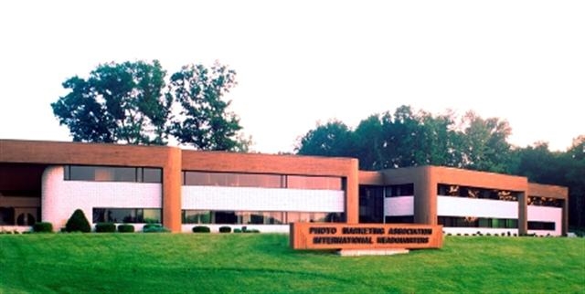
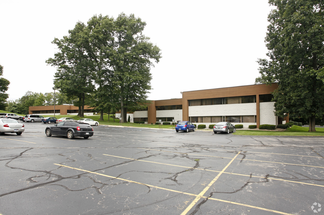
Property Record
3000 Blake Rd, Jackson, MI 49201

NEARBY LISTINGS FOR SALE OR LEASE
Property Detail
3000 Blake Rd
000-08-25-226-001-00
BEG AT NE COR OF SEC 25 TH S 1 DEG 20'08''W 488.2 FT TO A PT FOR PL OF BEG OF THIS DESCN TH CONTINUING S 1 DEG 20'08''W
Officebuilding
Jackson
X
Michigan
26075C0215D
25.50 AC
0
Jackson County
2024
West Michigan
005900
Jackson, MI
83,552 SF
DEMOGRAPHICS near 3000 Blake Rd
1 Mile
3 Mile
5 Mile
2024 Total Population
1,089
23,710
65,630
2029 Population
1,083
23,602
65,390
Pop Growth 2024-2029
(0.55%)
(0.46%)
(0.37%)
Average Age
41
39
39
2024 Total Households
452
9,660
27,602
HH Growth 2024-2029
(0.88%)
(0.43%)
(0.35%)
Median Household Inc
$41,597
$41,239
$46,912
Avg Household Size
2.30
2.30
2.30
2024 Avg HH Vehicles
2.00
2.00
2.00
Median Home Value
$131,879
$89,733
$113,397
Median Year Built
1959
1952
1955
Nearby Places
- Restaurants
- Banks
- Shops
- Fitness
- Groceries
PUBLIC TRANSPORTATION
COMMUTER RAIL
Jackson (Wolverine - Amtrak)
DRIVE
WALK
Distance
Jackson (Wolverine - Amtrak)
7 min
3.4 mi
Freight Ports
Port of Toledo
DRIVE
WALK
Distance
Port of Toledo
105 min
79.4 mi
Nearby Properties
Address
Land Use
TOTAL SIZE
Lot Size
Zoning
Address
Land Use
TOTAL SIZE
Lot Size
Zoning
392,155 SF
7.01 AC
C-3
Address
Land Use
TOTAL SIZE
Lot Size
Zoning
186,754 SF
16.63 AC
R-4 HI
Address
Land Use
TOTAL SIZE
Lot Size
Zoning
289,727 SF
145.86 AC
B-4 GEN
Address
Land Use
TOTAL SIZE
Lot Size
Zoning
13,124 SF
23.61 AC
I-2
Address
Land Use
TOTAL SIZE
Lot Size
Zoning
401,234 SF
23.40 AC
I-2
Address
Land Use
TOTAL SIZE
Lot Size
Zoning
223,693 SF
27.35 AC
B-4 GEN
Address
Land Use
TOTAL SIZE
Lot Size
Zoning
64,257 SF
1.90 AC
R-4
Address
Land Use
TOTAL SIZE
Lot Size
Zoning
62,227 SF
6.89 AC
R-1 ONE
Address
Land Use
TOTAL SIZE
Lot Size
Zoning
189,680 SF
6.90 AC
R-4
Address
Land Use
TOTAL SIZE
Lot Size
Zoning
251,350 SF
23.11 AC
I-1
Address
Land Use
TOTAL SIZE
Lot Size
Zoning
71,688 SF
12.64 AC
I-2
Address
Land Use
TOTAL SIZE
Lot Size
Zoning
154,448 SF
12.97 AC
PR-1
Address
Land Use
TOTAL SIZE
Lot Size
Zoning
57,057 SF
10.10 AC
C-3
Address
Land Use
TOTAL SIZE
Lot Size
Zoning
348,661 SF
5.29 AC
C-3
Address
Land Use
TOTAL SIZE
Lot Size
Zoning
67,146 SF
0.80 AC
C-3
Address
Land Use
TOTAL SIZE
Lot Size
Zoning
446,436 SF
19.65 AC
I-2
Address
Land Use
TOTAL SIZE
Lot Size
Zoning
180,410 SF
12.60 AC
RM-1
Address
Land Use
TOTAL SIZE
Lot Size
Zoning
111,312 SF
3.27 AC
R-2
Address
Land Use
TOTAL SIZE
Lot Size
Zoning
55,209 SF
5.67 AC
C-2
Address
Land Use
TOTAL SIZE
Lot Size
Zoning
35,908 SF
6 AC
R-4
Address
Land Use
TOTAL SIZE
Lot Size
Zoning
270,966 SF
67.92 AC
I-1
Address
Land Use
TOTAL SIZE
Lot Size
Zoning
89,888 SF
8 AC
R-3
Address
Land Use
TOTAL SIZE
Lot Size
Zoning
198,698 SF
4.22 AC
I-2
Address
Land Use
TOTAL SIZE
Lot Size
Zoning
126,176 SF
19.62 AC
PR-1
Address
Land Use
TOTAL SIZE
Lot Size
Zoning
64,185 SF
17.13 AC
C-3
Address
Land Use
TOTAL SIZE
Lot Size
Zoning
57,804 SF
3.77 AC
C-4
Address
Land Use
TOTAL SIZE
Lot Size
Zoning
54,464 SF
10.03 AC
ML LIGH
Address
Land Use
TOTAL SIZE
Lot Size
Zoning
67,289 SF
3.90 AC
C-1
Address
Land Use
TOTAL SIZE
Lot Size
Zoning
90,900 SF
6.94 AC
RM-1
Address
Land Use
TOTAL SIZE
Lot Size
Zoning
23,664 SF
0.19 AC
C-3
The World's #1 Commercial Real Estate Marketplace
Connect with us
© 2025 CoStar Group
The information above has been obtained from sources believed reliable. While we do not doubt its accuracy we have not verified it and make no guarantee, warranty or representation about it. It is your responsibility to independently confirm its accuracy and completeness. Any projections, opinions, assumptions, or estimates used are for example only and do not represent the current or future performance of the property. The value of this transaction to you depends on tax and other factors which should be evaluated by your tax, financial, and legal advisors. You and your advisors should conduct a careful, independent investigation of the property to determine to your satisfaction the suitability of the property for your needs.