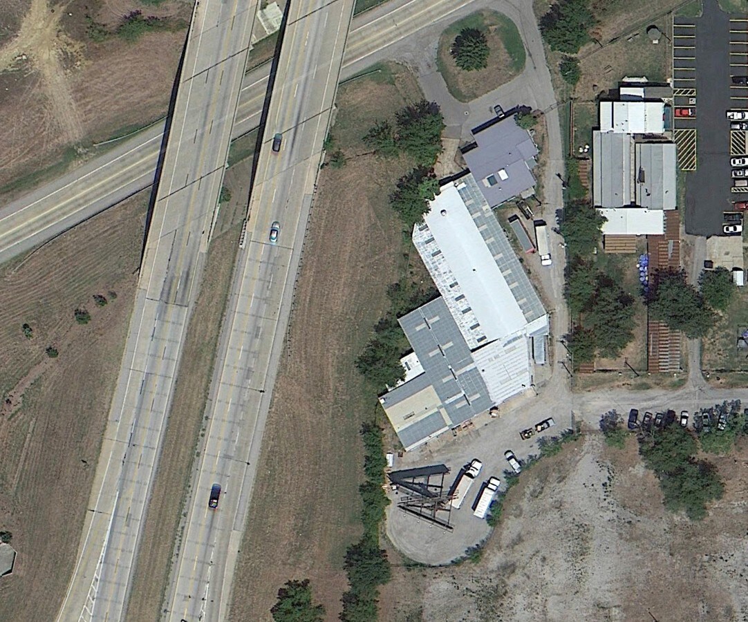
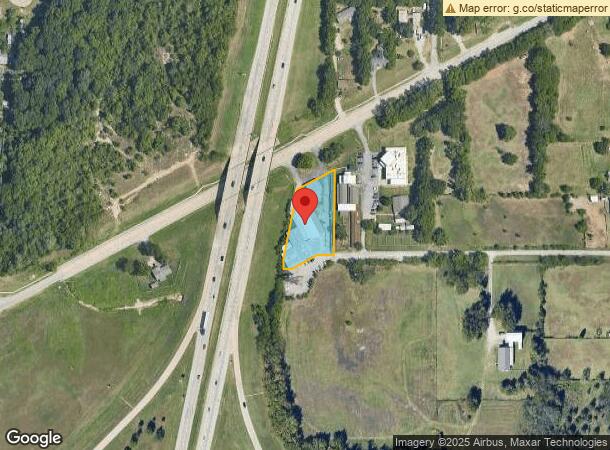
Property Record
3000 Mohawk Blvd, Tulsa, OK 74110
NEARBY LISTINGS FOR SALE OR LEASE
Property Detail
3000 Mohawk Blvd
90317-03-17-36320
Unplatted
Warehouse
BEG SECR NW SE TH W161.9 NE224.5 NE131.5 S281.5 POB & BEG 58.42W NEC SW SE SWLY88.35 W27 N39 NE2.9 E103 POB SEC 17 20 13 .88ACS
X
Tulsa
40143C0229L
Oklahoma
0
0.88 AC
2024
Northeast Tulsa
011300
Tulsa
20,445 SF
Tulsa, OK
DEMOGRAPHICS near 3000 Mohawk Blvd
1 Mile
3 Mile
5 Mile
2024 Total Population
2,205
42,610
112,284
2029 Population
2,319
44,810
117,577
Pop Growth 2024-2029
+ 5.17%
+ 5.16%
+ 4.71%
Average Age
33
36
36
2024 Total Households
721
15,335
43,006
HH Growth 2024-2029
+ 5.27%
+ 5.26%
+ 4.96%
Median Household Inc
$19,456
$31,039
$40,132
Avg Household Size
2.80
2.60
2.40
2024 Avg HH Vehicles
1.00
2.00
2.00
Median Home Value
$86,781
$64,264
$87,461
Median Year Built
1961
1957
1956
Nearby Places
- Restaurants
- Banks
- Shops
- Fitness
- Groceries
PUBLIC TRANSPORTATION
AIRPORT
Tulsa International
DRIVE
WALK
Distance
Tulsa International
8 min
4.1 mi
Freight Ports
Tulsa Port Of Catoosa
DRIVE
WALK
Distance
Tulsa Port Of Catoosa
18 min
12.2 mi
Nearby Properties
Address
Land Use
TOTAL SIZE
Lot Size
Zoning
Address
Land Use
TOTAL SIZE
Lot Size
Zoning
353.75 AC
IL
Address
Land Use
TOTAL SIZE
Lot Size
Zoning
144,570 SF
44.59 AC
RM2
Address
Land Use
TOTAL SIZE
Lot Size
Zoning
94,115 SF
15.18 AC
IM
Address
Land Use
TOTAL SIZE
Lot Size
Zoning
195,492 SF
17.11 AC
RM1
Address
Land Use
TOTAL SIZE
Lot Size
Zoning
42,665 SF
493.63 AC
RS3
Address
Land Use
TOTAL SIZE
Lot Size
Zoning
106,579 SF
6.76 AC
RM1
Address
Land Use
TOTAL SIZE
Lot Size
Zoning
121,518 SF
8.52 AC
IM
Address
Land Use
TOTAL SIZE
Lot Size
Zoning
56,476 SF
2.89 AC
RM2
Address
Land Use
TOTAL SIZE
Lot Size
Zoning
29,584 SF
2.99 AC
IM
Address
Land Use
TOTAL SIZE
Lot Size
Zoning
41,874 SF
35.70 AC
RS3
Address
Land Use
TOTAL SIZE
Lot Size
Zoning
92,364 SF
8.58 AC
RM1
Address
Land Use
TOTAL SIZE
Lot Size
Zoning
32,700 SF
10.08 AC
AG
Address
Land Use
TOTAL SIZE
Lot Size
Zoning
41,728 SF
10.06 AC
RS3
Address
Land Use
TOTAL SIZE
Lot Size
Zoning
513.99 AC
RS3
Address
Land Use
TOTAL SIZE
Lot Size
Zoning
36,450 SF
30.52 AC
RS3
Address
Land Use
TOTAL SIZE
Lot Size
Zoning
51,485 SF
8.71 AC
IM
Address
Land Use
TOTAL SIZE
Lot Size
Zoning
39,889 SF
3.62 AC
IL
Address
Land Use
TOTAL SIZE
Lot Size
Zoning
43,225 SF
9.30 AC
RS3
Address
Land Use
TOTAL SIZE
Lot Size
Zoning
45,883 SF
10.29 AC
RS3
Address
Land Use
TOTAL SIZE
Lot Size
Zoning
16,164 SF
1.23 AC
CN
Address
Land Use
TOTAL SIZE
Lot Size
Zoning
55,867 SF
7.94 AC
RS
Address
Land Use
TOTAL SIZE
Lot Size
Zoning
35,336 SF
1.68 AC
RS3
Address
Land Use
TOTAL SIZE
Lot Size
Zoning
5,670 SF
96.05 AC
AG
Address
Land Use
TOTAL SIZE
Lot Size
Zoning
51,810 SF
7.61 AC
CS
Address
Land Use
TOTAL SIZE
Lot Size
Zoning
31,154 SF
9.74 AC
RS3
Address
Land Use
TOTAL SIZE
Lot Size
Zoning
14,400 SF
2.32 AC
IL
Address
Land Use
TOTAL SIZE
Lot Size
Zoning
29,065 SF
111.30 AC
RS
Address
Land Use
TOTAL SIZE
Lot Size
Zoning
34,580 SF
15 AC
RS3
Address
Land Use
TOTAL SIZE
Lot Size
Zoning
45,488 SF
2.22 AC
IL
Address
Land Use
TOTAL SIZE
Lot Size
Zoning
11,402 SF
3 AC
CS
The World's #1 Commercial Real Estate Marketplace
Connect with us
© 2025 CoStar Group
The information above has been obtained from sources believed reliable. While we do not doubt its accuracy we have not verified it and make no guarantee, warranty or representation about it. It is your responsibility to independently confirm its accuracy and completeness. Any projections, opinions, assumptions, or estimates used are for example only and do not represent the current or future performance of the property. The value of this transaction to you depends on tax and other factors which should be evaluated by your tax, financial, and legal advisors. You and your advisors should conduct a careful, independent investigation of the property to determine to your satisfaction the suitability of the property for your needs.