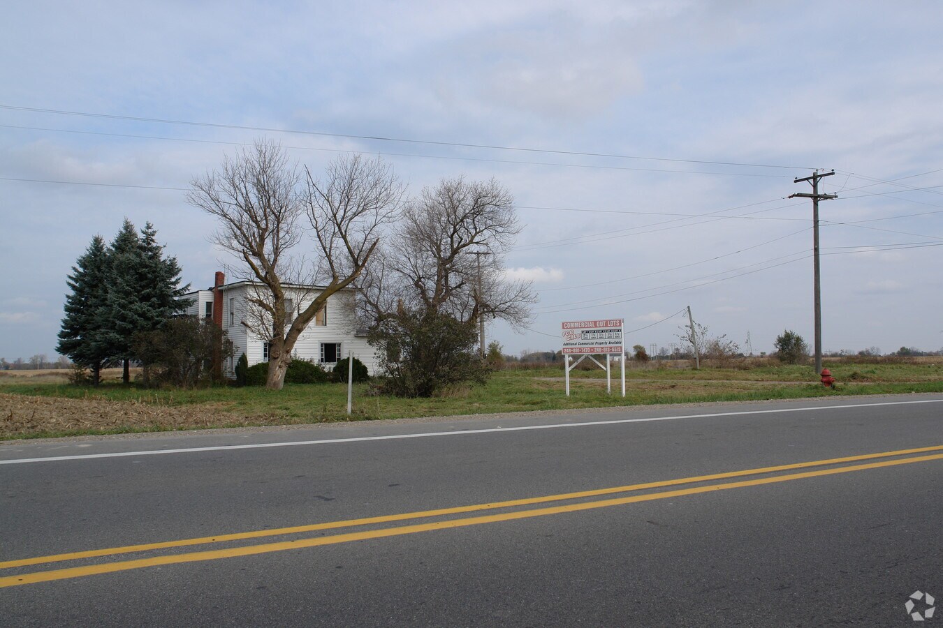
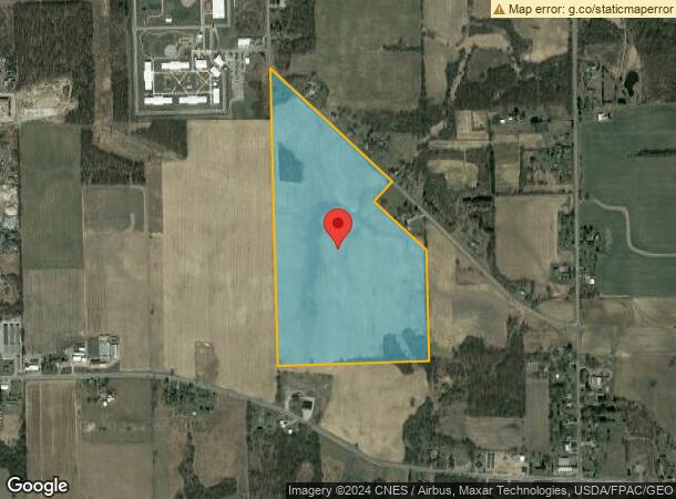
Property Record
3000 Parr Hwy, Adrian, MI 49221
NEARBY LISTINGS FOR SALE OR LEASE
-
-
View all Adrian listings for sale on LoopNet.com
Property Detail
3000 Parr Hwy
PA0-107-3550-00
LD DES AS BEG AT THE SW COR OF SEC 7 T7S R4E TH ALG THE W LI OF SD SEC N 2578.17 FT TO THE E1/4 COR OF SEC 12 T7S R3E TH ALG
Agriculturalland
Lenawee
X
Michigan
26091C0194D
82.13 AC
2023
Lenawee County
2024
Toledo
061400
Adrian, MI
DEMOGRAPHICS near 3000 Parr Hwy
1 Mile
3 Mile
5 Mile
2024 Total Population
755
20,663
35,774
2029 Population
748
20,473
35,427
Pop Growth 2024-2029
(0.93%)
(0.92%)
(0.97%)
Average Age
42
39
40
2024 Total Households
201
7,366
13,004
HH Growth 2024-2029
(0.50%)
(0.96%)
(1.02%)
Median Household Inc
$60,341
$38,060
$48,479
Avg Household Size
2.50
2.30
2.30
2024 Avg HH Vehicles
2.00
2.00
2.00
Median Home Value
$138,666
$90,025
$132,935
Median Year Built
1972
1960
1968
Nearby Places
- Restaurants
- Banks
- Shops
- Fitness
- Groceries
PUBLIC TRANSPORTATION
AIRPORT
Eugene F Kranz Toledo Express
DRIVE
WALK
Distance
Eugene F Kranz Toledo Express
57 min
35.6 mi
Freight Ports
Port of Toledo
DRIVE
WALK
Distance
Port of Toledo
59 min
39.3 mi
SALE & LEASE HISTORY
LISTING DATE
SALE/LEASE

Sep 24, 2016
For Sale
Nearby Properties
Address
Land Use
TOTAL SIZE
Lot Size
Zoning
Address
Land Use
TOTAL SIZE
Lot Size
Zoning
198,348 SF
28.50 AC
Address
Land Use
TOTAL SIZE
Lot Size
Zoning
21.68 AC
B-4
Address
Land Use
TOTAL SIZE
Lot Size
Zoning
Address
Land Use
TOTAL SIZE
Lot Size
Zoning
51,068 SF
7.07 AC
Address
Land Use
TOTAL SIZE
Lot Size
Zoning
83,180 SF
3.14 AC
ERO
Address
Land Use
TOTAL SIZE
Lot Size
Zoning
101,287 SF
16.98 AC
B-4
Address
Land Use
TOTAL SIZE
Lot Size
Zoning
805,326 SF
50.38 AC
Address
Land Use
TOTAL SIZE
Lot Size
Zoning
35,880 SF
2.45 AC
Address
Land Use
TOTAL SIZE
Lot Size
Zoning
53,333 SF
6.70 AC
B-4
Address
Land Use
TOTAL SIZE
Lot Size
Zoning
512,408 SF
33.83 AC
I-2
Address
Land Use
TOTAL SIZE
Lot Size
Zoning
49,676 SF
0.94 AC
RM-2
Address
Land Use
TOTAL SIZE
Lot Size
Zoning
86,479 SF
4.79 AC
Address
Land Use
TOTAL SIZE
Lot Size
Zoning
29.25 AC
B-4
Address
Land Use
TOTAL SIZE
Lot Size
Zoning
42,682 SF
6.41 AC
B-2
Address
Land Use
TOTAL SIZE
Lot Size
Zoning
191,777 SF
6.15 AC
E-1
Address
Land Use
TOTAL SIZE
Lot Size
Zoning
17,751 SF
2.76 AC
B-2
Address
Land Use
TOTAL SIZE
Lot Size
Zoning
35,534 SF
4.48 AC
Address
Land Use
TOTAL SIZE
Lot Size
Zoning
68,520 SF
7.01 AC
RM-1
Address
Land Use
TOTAL SIZE
Lot Size
Zoning
37.20 AC
Address
Land Use
TOTAL SIZE
Lot Size
Zoning
5,459 SF
10.01 AC
Address
Land Use
TOTAL SIZE
Lot Size
Zoning
352,875 SF
12.08 AC
I-1
Address
Land Use
TOTAL SIZE
Lot Size
Zoning
60,039 SF
12.03 AC
RM-1
Address
Land Use
TOTAL SIZE
Lot Size
Zoning
88,800 SF
13.84 AC
E-1
Address
Land Use
TOTAL SIZE
Lot Size
Zoning
17,154 SF
0.20 AC
B-3
Address
Land Use
TOTAL SIZE
Lot Size
Zoning
266.96 AC
Address
Land Use
TOTAL SIZE
Lot Size
Zoning
115,500 SF
2.32 AC
RM-2
Address
Land Use
TOTAL SIZE
Lot Size
Zoning
93,492 SF
2.47 AC
Address
Land Use
TOTAL SIZE
Lot Size
Zoning
68,368 SF
7.31 AC
Address
Land Use
TOTAL SIZE
Lot Size
Zoning
55,698 SF
3.42 AC
RM-1
Address
Land Use
TOTAL SIZE
Lot Size
Zoning
49,635 SF
14.07 AC
The World's #1 Commercial Real Estate Marketplace
Connect with us
© 2025 CoStar Group
The information above has been obtained from sources believed reliable. While we do not doubt its accuracy we have not verified it and make no guarantee, warranty or representation about it. It is your responsibility to independently confirm its accuracy and completeness. Any projections, opinions, assumptions, or estimates used are for example only and do not represent the current or future performance of the property. The value of this transaction to you depends on tax and other factors which should be evaluated by your tax, financial, and legal advisors. You and your advisors should conduct a careful, independent investigation of the property to determine to your satisfaction the suitability of the property for your needs.