Property Record
301 Expressway, Missoula, MT 59808


NEARBY LISTINGS FOR SALE OR LEASE
Property Detail
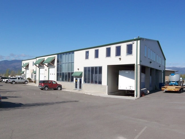
301 Expressway
Missoula, MT
Grant Creek Center - Phase Ii
04-2200-07-1-02-04-0000
GRANT CREEK CENTER - PHASE II, S07, T13 N, R19 W, LOT 33
Commercialnec
Missoula
X
Montana
30063C1195E
33
2024
1.04 AC
2025
Missoula
000206
Other Market Areas
23,089 SF
DEMOGRAPHICS near 301 Expressway
1 Mile
3 Mile
5 Mile
2024 Total Population
6,574
31,467
77,854
2029 Population
7,256
34,338
84,389
Pop Growth 2024-2029
+ 10.37%
+ 9.12%
+ 8.39%
Average Age
39
38
38
2024 Total Households
3,009
14,797
35,060
HH Growth 2024-2029
+ 10.50%
+ 9.30%
+ 8.57%
Median Household Inc
$65,875
$55,766
$60,332
Avg Household Size
2.10
2.00
2.10
2024 Avg HH Vehicles
2.00
2.00
2.00
Median Home Value
$330,434
$332,190
$372,441
Median Year Built
2007
2001
1986
Nearby Places
Map Layers
Map Styles
 Street
 Aerial
- Restaurants
- Banks
- Shops
- Fitness
- Groceries
PUBLIC TRANSPORTATION
AIRPORT
Missoula Montana
DRIVE
WALK
Distance
Missoula Montana
8 min
2.8 mi
Freight Ports
Port of Everett
DRIVE
WALK
Distance
Port of Everett
546 min
495.9 mi
SALE & LEASE HISTORY
LISTING DATE
SALE/LEASE

Sep 24, 2016
For Sale
Oct 19, 2021
For Lease
May 26, 2017
For Lease
May 26, 2017
For Sale
Nearby Properties
Address
Land Use
TOTAL SIZE
Lot Size
Zoning
Address
Land Use
TOTAL SIZE
Lot Size
Zoning
352,710 SF
Address
Land Use
TOTAL SIZE
Lot Size
Zoning
252,171 SF
8.63 AC
Address
Land Use
TOTAL SIZE
Lot Size
Zoning
157,658 SF
2.04 AC
Address
Land Use
TOTAL SIZE
Lot Size
Zoning
187,680 SF
10.06 AC
Address
Land Use
TOTAL SIZE
Lot Size
Zoning
61,762 SF
8.48 AC
Address
Land Use
TOTAL SIZE
Lot Size
Zoning
179,712 SF
7.60 AC
Address
Land Use
TOTAL SIZE
Lot Size
Zoning
175,964 SF
5.01 AC
Address
Land Use
TOTAL SIZE
Lot Size
Zoning
50,795 SF
18.10 AC
Address
Land Use
TOTAL SIZE
Lot Size
Zoning
138,544 SF
5.28 AC
Address
Land Use
TOTAL SIZE
Lot Size
Zoning
61,800 SF
6.11 AC
Address
Land Use
TOTAL SIZE
Lot Size
Zoning
35,884 SF
7.40 AC
6
Address
Land Use
TOTAL SIZE
Lot Size
Zoning
125,976 SF
10.64 AC
1
Address
Land Use
TOTAL SIZE
Lot Size
Zoning
73,710 SF
12.42 AC
Address
Land Use
TOTAL SIZE
Lot Size
Zoning
128,120 SF
1.15 AC
5
Address
Land Use
TOTAL SIZE
Lot Size
Zoning
73,710 SF
12.42 AC
Address
Land Use
TOTAL SIZE
Lot Size
Zoning
55,528 SF
36.48 AC
Address
Land Use
TOTAL SIZE
Lot Size
Zoning
205,960 SF
18.52 AC
Address
Land Use
TOTAL SIZE
Lot Size
Zoning
105,004 SF
3.45 AC
Address
Land Use
TOTAL SIZE
Lot Size
Zoning
73,143 SF
6.54 AC
7
Address
Land Use
TOTAL SIZE
Lot Size
Zoning
133,210 SF
11.25 AC
Address
Land Use
TOTAL SIZE
Lot Size
Zoning
55,280 SF
3.12 AC
Address
Land Use
TOTAL SIZE
Lot Size
Zoning
160,516 SF
13.50 AC
Address
Land Use
TOTAL SIZE
Lot Size
Zoning
98,144 SF
7.50 AC
6
Address
Land Use
TOTAL SIZE
Lot Size
Zoning
121,176 SF
12.23 AC
8
Address
Land Use
TOTAL SIZE
Lot Size
Zoning
1,342.09 AC
Address
Land Use
TOTAL SIZE
Lot Size
Zoning
130,275 SF
10.17 AC
7
Address
Land Use
TOTAL SIZE
Lot Size
Zoning
34,404 SF
10.25 AC
6
Address
Land Use
TOTAL SIZE
Lot Size
Zoning
51,891 SF
1.61 AC
7
Address
Land Use
TOTAL SIZE
Lot Size
Zoning
1,056 SF
39.84 AC
5
The World's #1 Commercial Real Estate Marketplace
Connect with us
© 2026 CoStar Group
The information above has been obtained from sources believed reliable. While we do not doubt its accuracy we have not verified it and make no guarantee, warranty or representation about it. It is your responsibility to independently confirm its accuracy and completeness. Any projections, opinions, assumptions, or estimates used are for example only and do not represent the current or future performance of the property. The value of this transaction to you depends on tax and other factors which should be evaluated by your tax, financial, and legal advisors. You and your advisors should conduct a careful, independent investigation of the property to determine to your satisfaction the suitability of the property for your needs.