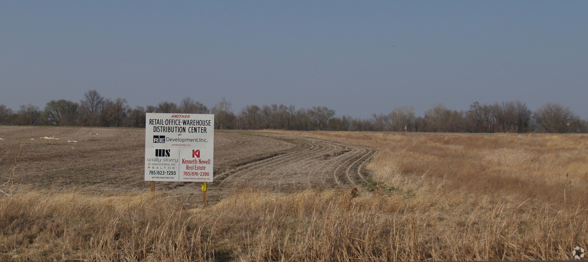
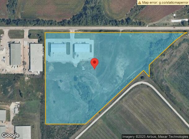
Property Record
301 Se 53Rd St, Topeka, KS 66609

NEARBY LISTINGS FOR SALE OR LEASE
Property Detail
301 Se 53Rd St
Topeka, KS
South Topeka Industrial Plaza No 4
139-31-0-00-01-002-020
SOUTH TOPEKA INDUSTRIAL PLAZA NO 4, S31, T12, R16, BLOCK A, LOT 1, ACRES 18.26, LOT 1 SOUTH TOPEKA INDUSTRIAL PLAZA NO 4
Shipyard
Shawnee
X
Kansas
20177C0306E
1
2023
18.26 AC
2023
Topeka
003702
Kansas City
12,000 SF
DEMOGRAPHICS near 301 Se 53Rd St
1 Mile
3 Mile
5 Mile
2024 Total Population
1,161
22,081
72,925
2029 Population
1,166
21,947
72,353
Pop Growth 2024-2029
+ 0.43%
(0.61%)
(0.78%)
Average Age
45
38
39
2024 Total Households
550
8,479
29,941
HH Growth 2024-2029
+ 0.36%
(0.57%)
(0.85%)
Median Household Inc
$51,798
$53,973
$52,134
Avg Household Size
2.10
2.50
2.30
2024 Avg HH Vehicles
2.00
2.00
2.00
Median Home Value
$79,137
$129,202
$133,098
Median Year Built
1986
1974
1970
Nearby Places
- Restaurants
- Banks
- Shops
- Fitness
- Groceries
PUBLIC TRANSPORTATION
COMMUTER RAIL
Topeka Amtrak Station (Southwest Chief - Amtrak)
DRIVE
WALK
Distance
Topeka Amtrak Station (Southwest Chief - Amtrak)
13 min
6.9 mi
Freight Ports
Tulsa Port Of Catoosa
DRIVE
WALK
Distance
Tulsa Port Of Catoosa
269 min
219.5 mi
SALE & LEASE HISTORY
LISTING DATE
SALE/LEASE

Sep 24, 2016
For Sale
Nearby Properties
Address
Land Use
TOTAL SIZE
Lot Size
Zoning
Address
Land Use
TOTAL SIZE
Lot Size
Zoning
194.03 AC
I2
Address
Land Use
TOTAL SIZE
Lot Size
Zoning
42.18 AC
I2
Address
Land Use
TOTAL SIZE
Lot Size
Zoning
77,776 SF
10.64 AC
PUD,M2,R1,
Address
Land Use
TOTAL SIZE
Lot Size
Zoning
797,582 SF
384.32 AC
I1,I2
Address
Land Use
TOTAL SIZE
Lot Size
Zoning
103,285 SF
16.99 AC
I1,PUD
Address
Land Use
TOTAL SIZE
Lot Size
Zoning
1,351,980 SF
141.63 AC
I1
Address
Land Use
TOTAL SIZE
Lot Size
Zoning
602,448 SF
43.68 AC
I1
Address
Land Use
TOTAL SIZE
Lot Size
Zoning
165,001 SF
24.83 AC
R1
Address
Land Use
TOTAL SIZE
Lot Size
Zoning
1,250 SF
630.34 AC
RR1
Address
Land Use
TOTAL SIZE
Lot Size
Zoning
156,628 SF
44.05 AC
I1
Address
Land Use
TOTAL SIZE
Lot Size
Zoning
465,600 SF
52.91 AC
I1
Address
Land Use
TOTAL SIZE
Lot Size
Zoning
40,321 SF
5.69 AC
I1
Address
Land Use
TOTAL SIZE
Lot Size
Zoning
93,571 SF
5.58 AC
PUD
Address
Land Use
TOTAL SIZE
Lot Size
Zoning
56,485 SF
11.58 AC
I1
Address
Land Use
TOTAL SIZE
Lot Size
Zoning
188,358 SF
183.64 AC
I1,RR1
Address
Land Use
TOTAL SIZE
Lot Size
Zoning
4.80 AC
Address
Land Use
TOTAL SIZE
Lot Size
Zoning
64,248 SF
13.78 AC
RR1
Address
Land Use
TOTAL SIZE
Lot Size
Zoning
40,591 SF
6.19 AC
R1
Address
Land Use
TOTAL SIZE
Lot Size
Zoning
53,815 SF
15.40 AC
RR1
Address
Land Use
TOTAL SIZE
Lot Size
Zoning
207,235 SF
22.74 AC
C3
Address
Land Use
TOTAL SIZE
Lot Size
Zoning
23,026 SF
8.62 AC
R1,RR1
Address
Land Use
TOTAL SIZE
Lot Size
Zoning
134,915 SF
20 AC
I1
Address
Land Use
TOTAL SIZE
Lot Size
Zoning
35,832 SF
7.55 AC
R1
Address
Land Use
TOTAL SIZE
Lot Size
Zoning
100,822 SF
8.50 AC
C4
Address
Land Use
TOTAL SIZE
Lot Size
Zoning
28,158 SF
12.12 AC
PUD,R1
Address
Land Use
TOTAL SIZE
Lot Size
Zoning
417.49 AC
RR1
Address
Land Use
TOTAL SIZE
Lot Size
Zoning
577,341 SF
152.58 AC
I2
Address
Land Use
TOTAL SIZE
Lot Size
Zoning
1,253,081 SF
74.88 AC
I1
Address
Land Use
TOTAL SIZE
Lot Size
Zoning
36,512 SF
6.72 AC
R2
Address
Land Use
TOTAL SIZE
Lot Size
Zoning
18.56 AC
I1
The World's #1 Commercial Real Estate Marketplace
Connect with us
© 2025 CoStar Group
The information above has been obtained from sources believed reliable. While we do not doubt its accuracy we have not verified it and make no guarantee, warranty or representation about it. It is your responsibility to independently confirm its accuracy and completeness. Any projections, opinions, assumptions, or estimates used are for example only and do not represent the current or future performance of the property. The value of this transaction to you depends on tax and other factors which should be evaluated by your tax, financial, and legal advisors. You and your advisors should conduct a careful, independent investigation of the property to determine to your satisfaction the suitability of the property for your needs.