Property Record
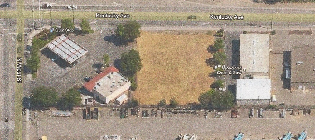
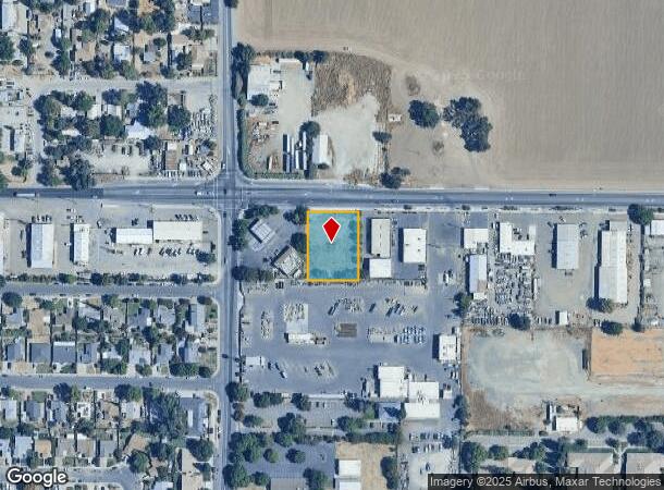
22 Kentucky Ave, Woodland, CA 95695

NEARBY LISTINGS FOR SALE OR LEASE
Property Detail
22 Kentucky Ave
Sacramento--Roseville--Arden-Arcade, CA
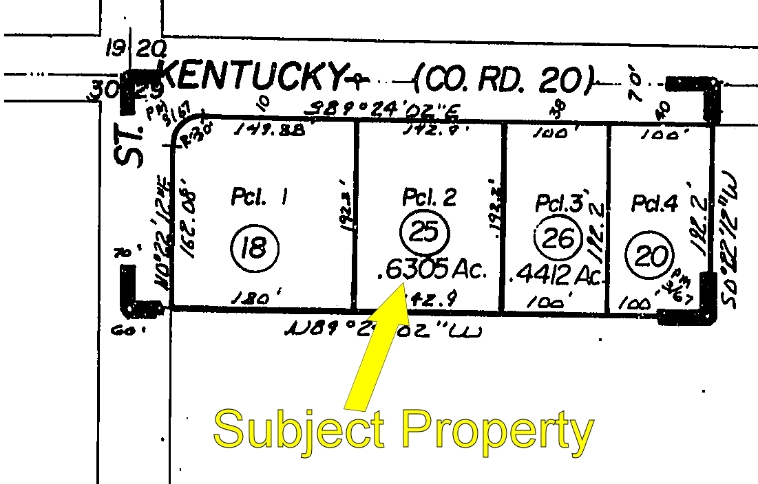
As Shown On Parcel Map No. 2622
005-720-025-000
PM 2622 PCL 2 PM BK 3 PG 67
Commercialacreage
Yolo
X
California
06113C0435H
2
2024
0.63 AC
2023
Davis/Woodland
010901
Sacramento
DEMOGRAPHICS near 22 Kentucky Ave
1 Mile
3 Mile
5 Mile
2024 Total Population
12,309
52,183
65,564
2029 Population
12,437
52,808
66,554
Pop Growth 2024-2029
+ 1.04%
+ 1.20%
+ 1.51%
Average Age
38
39
38
2024 Total Households
4,190
18,129
22,325
HH Growth 2024-2029
+ 0.98%
+ 1.20%
+ 1.49%
Median Household Inc
$67,212
$72,730
$78,969
Avg Household Size
2.70
2.80
2.80
2024 Avg HH Vehicles
2.00
2.00
2.00
Median Home Value
$388,117
$448,590
$471,311
Median Year Built
1972
1976
1981
Nearby Places
- Restaurants
- Banks
- Shops
- Fitness
- Groceries
PUBLIC TRANSPORTATION
AIRPORT
Sacramento International
DRIVE
WALK
Distance
Sacramento International
19 min
13.1 mi
Freight Ports
Port of Stockton
DRIVE
WALK
Distance
Port of Stockton
77 min
66.6 mi
SALE & LEASE HISTORY
LISTING DATE
SALE/LEASE

Sep 21, 2021
For Sale
Nov 19, 2020
For Sale
Jun 15, 2023
For Sale
Nearby Properties
Address
Land Use
TOTAL SIZE
Lot Size
Zoning
Address
Land Use
TOTAL SIZE
Lot Size
Zoning
112.50 AC
A1
Address
Land Use
TOTAL SIZE
Lot Size
Zoning
23.92 AC
M2
Address
Land Use
TOTAL SIZE
Lot Size
Zoning
180,816 SF
0.17 AC
R-M
Address
Land Use
TOTAL SIZE
Lot Size
Zoning
515,886 SF
71.53 AC
I
Address
Land Use
TOTAL SIZE
Lot Size
Zoning
348,386 SF
17.67 AC
RM
Address
Land Use
TOTAL SIZE
Lot Size
Zoning
87.49 AC
A1
Address
Land Use
TOTAL SIZE
Lot Size
Zoning
38.27 AC
I
Address
Land Use
TOTAL SIZE
Lot Size
Zoning
151,244 SF
8.17 AC
R3
Address
Land Use
TOTAL SIZE
Lot Size
Zoning
9.89 AC
M1
Address
Land Use
TOTAL SIZE
Lot Size
Zoning
260,400 SF
12.30 AC
I
Address
Land Use
TOTAL SIZE
Lot Size
Zoning
83,280 SF
4.49 AC
R-M
Address
Land Use
TOTAL SIZE
Lot Size
Zoning
260,400 SF
12.79 AC
I
Address
Land Use
TOTAL SIZE
Lot Size
Zoning
356,360 SF
26.50 AC
M2
Address
Land Use
TOTAL SIZE
Lot Size
Zoning
324,475 SF
22.49 AC
I
Address
Land Use
TOTAL SIZE
Lot Size
Zoning
427,073 SF
24.51 AC
I
Address
Land Use
TOTAL SIZE
Lot Size
Zoning
26.48 AC
A1
Address
Land Use
TOTAL SIZE
Lot Size
Zoning
94,860 SF
11.70 AC
EOZ-I/PD
Address
Land Use
TOTAL SIZE
Lot Size
Zoning
128,755 SF
13.61 AC
C2
Address
Land Use
TOTAL SIZE
Lot Size
Zoning
101,334 SF
8.52 AC
C2
Address
Land Use
TOTAL SIZE
Lot Size
Zoning
4.72 AC
R1
Address
Land Use
TOTAL SIZE
Lot Size
Zoning
9.81 AC
R-M
Address
Land Use
TOTAL SIZE
Lot Size
Zoning
5.69 AC
I
Address
Land Use
TOTAL SIZE
Lot Size
Zoning
90,570 SF
8.08 AC
C2
Address
Land Use
TOTAL SIZE
Lot Size
Zoning
64,896 SF
4.39 AC
R-M
Address
Land Use
TOTAL SIZE
Lot Size
Zoning
126,392 SF
6 AC
C2
Address
Land Use
TOTAL SIZE
Lot Size
Zoning
58,050 SF
6.55 AC
R-M
Address
Land Use
TOTAL SIZE
Lot Size
Zoning
569,401 SF
21.15 AC
I
Address
Land Use
TOTAL SIZE
Lot Size
Zoning
319,800 SF
14.94 AC
I
Address
Land Use
TOTAL SIZE
Lot Size
Zoning
4,050 SF
18.03 AC
I
Address
Land Use
TOTAL SIZE
Lot Size
Zoning
130,647 SF
7.25 AC
R2
The World's #1 Commercial Real Estate Marketplace
Connect with us
© 2025 CoStar Group
The information above has been obtained from sources believed reliable. While we do not doubt its accuracy we have not verified it and make no guarantee, warranty or representation about it. It is your responsibility to independently confirm its accuracy and completeness. Any projections, opinions, assumptions, or estimates used are for example only and do not represent the current or future performance of the property. The value of this transaction to you depends on tax and other factors which should be evaluated by your tax, financial, and legal advisors. You and your advisors should conduct a careful, independent investigation of the property to determine to your satisfaction the suitability of the property for your needs.