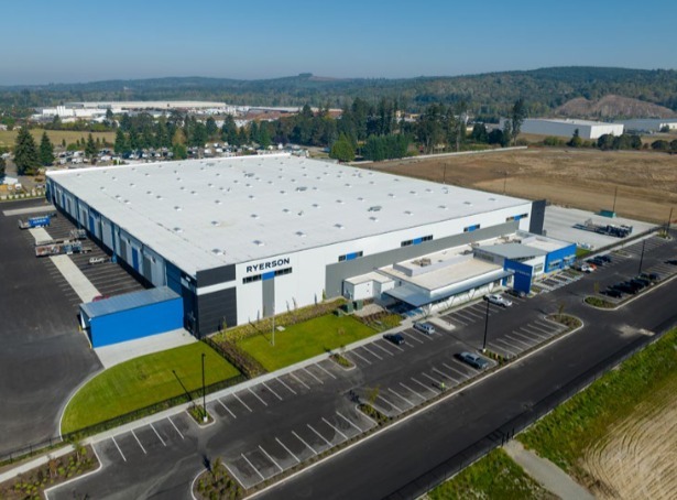
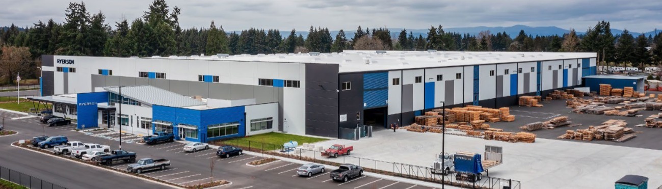
Property Record
3010 Harrison Ave, Centralia, WA 98531
NEARBY LISTINGS FOR SALE OR LEASE
Property Detail
3010 Harrison Ave
Other Market Areas
City Of Centralia Boundary Line Adjustme
Centralia, WA
Lewis
023765-001-001
Washington
Lightindustrial
15.22 AC
1,427 SF
Washington State Area
DEMOGRAPHICS near 3010 Harrison Ave
1 Mile
3 Mile
5 Mile
2024 Total Population
1,455
17,203
34,080
2029 Population
1,608
19,170
37,752
Pop Growth 2024-2029
+ 10.52%
+ 11.43%
+ 10.77%
Average Age
42
41
40
2024 Total Households
586
6,708
12,874
HH Growth 2024-2029
+ 10.58%
+ 11.61%
+ 10.96%
Median Household Inc
$47,589
$56,526
$61,042
Avg Household Size
2.50
2.50
2.60
2024 Avg HH Vehicles
2.00
2.00
2.00
Median Home Value
$297,894
$300,377
$315,984
Median Year Built
1979
1982
1982
Nearby Places
- Restaurants
- Banks
- Shops
- Fitness
- Groceries
PUBLIC TRANSPORTATION
COMMUTER RAIL
Centralia Amtrak Station (Amtrak Cascades - Amtrak, Coast Starlight - Amtrak)
DRIVE
WALK
Distance
Centralia Amtrak Station (Amtrak Cascades - Amtrak, Coast Starlight - Amtrak)
10 min
4.0 mi
Freight Ports
Port of Grays Harbor, WA
DRIVE
WALK
Distance
Port of Grays Harbor, WA
78 min
51.3 mi
SALE & LEASE HISTORY
LISTING DATE
SALE/LEASE

Jul 17, 2023
For Sale
Nearby Properties
Address
Land Use
TOTAL SIZE
Lot Size
Zoning
Address
Land Use
TOTAL SIZE
Lot Size
Zoning
1,038,447 SF
77 AC
PMP
Address
Land Use
TOTAL SIZE
Lot Size
Zoning
441,608 SF
Address
Land Use
TOTAL SIZE
Lot Size
Zoning
32,914 SF
3.38 AC
PMP
Address
Land Use
TOTAL SIZE
Lot Size
Zoning
Address
Land Use
TOTAL SIZE
Lot Size
Zoning
155,458 SF
15.80 AC
PMP
Address
Land Use
TOTAL SIZE
Lot Size
Zoning
648,548 SF
16.50 AC
Address
Land Use
TOTAL SIZE
Lot Size
Zoning
61,618 SF
11.91 AC
M1
Address
Land Use
TOTAL SIZE
Lot Size
Zoning
Address
Land Use
TOTAL SIZE
Lot Size
Zoning
1,792 SF
38.78 AC
OSPF
Address
Land Use
TOTAL SIZE
Lot Size
Zoning
14,264 SF
6.60 AC
R20
Address
Land Use
TOTAL SIZE
Lot Size
Zoning
2,956 SF
4.99 AC
R15
Address
Land Use
TOTAL SIZE
Lot Size
Zoning
64,421 SF
5 AC
H1
Address
Land Use
TOTAL SIZE
Lot Size
Zoning
196,060 SF
24.68 AC
PMP
Address
Land Use
TOTAL SIZE
Lot Size
Zoning
57,621 SF
5.33 AC
H1
Address
Land Use
TOTAL SIZE
Lot Size
Zoning
7,200 SF
4 AC
OSPF
Address
Land Use
TOTAL SIZE
Lot Size
Zoning
4,420 SF
3.91 AC
R20
Address
Land Use
TOTAL SIZE
Lot Size
Zoning
75,993 SF
18.76 AC
PMP
Address
Land Use
TOTAL SIZE
Lot Size
Zoning
Address
Land Use
TOTAL SIZE
Lot Size
Zoning
Address
Land Use
TOTAL SIZE
Lot Size
Zoning
3,196 SF
4.48 AC
R15
Address
Land Use
TOTAL SIZE
Lot Size
Zoning
48,865 SF
4.70 AC
H1
Address
Land Use
TOTAL SIZE
Lot Size
Zoning
75,600 SF
Address
Land Use
TOTAL SIZE
Lot Size
Zoning
Address
Land Use
TOTAL SIZE
Lot Size
Zoning
3,536 SF
1.73 AC
R20
Address
Land Use
TOTAL SIZE
Lot Size
Zoning
1,512 SF
8.64 AC
OSPF
Address
Land Use
TOTAL SIZE
Lot Size
Zoning
2,408 SF
2.08 AC
R20
Address
Land Use
TOTAL SIZE
Lot Size
Zoning
34,408 SF
3.58 AC
C1
Address
Land Use
TOTAL SIZE
Lot Size
Zoning
2,088 SF
1.48 AC
R15
Address
Land Use
TOTAL SIZE
Lot Size
Zoning
4,104 SF
79.55 AC
M2
The World's #1 Commercial Real Estate Marketplace
Connect with us
© 2025 CoStar Group
The information above has been obtained from sources believed reliable. While we do not doubt its accuracy we have not verified it and make no guarantee, warranty or representation about it. It is your responsibility to independently confirm its accuracy and completeness. Any projections, opinions, assumptions, or estimates used are for example only and do not represent the current or future performance of the property. The value of this transaction to you depends on tax and other factors which should be evaluated by your tax, financial, and legal advisors. You and your advisors should conduct a careful, independent investigation of the property to determine to your satisfaction the suitability of the property for your needs.