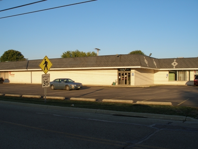
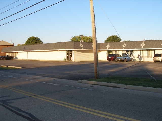
Property Record
302 Eaton Lewisburg Rd, Eaton, OH 45320
NEARBY LISTINGS FOR SALE OR LEASE
Property Detail
302 Eaton Lewisburg Rd
M40-0006-0-0-80-100-1000
Black Fudge Subd
Officebuilding
LOT 1720 BLACK FUDGE SUBD
X
Preble
39135C0145E
Ohio
0
1720
2024
1.37 AC
455002
Preble County
11,750 SF
Cincinnati/Dayton
DEMOGRAPHICS near 302 Eaton Lewisburg Rd
1 Mile
3 Mile
5 Mile
2024 Total Population
4,259
10,206
12,844
2029 Population
4,247
10,190
12,814
Pop Growth 2024-2029
(0.28%)
(0.16%)
(0.23%)
Average Age
45
43
43
2024 Total Households
1,897
4,355
5,394
HH Growth 2024-2029
(0.42%)
(0.23%)
(0.30%)
Median Household Inc
$49,943
$52,928
$55,505
Avg Household Size
2.10
2.30
2.30
2024 Avg HH Vehicles
2.00
2.00
2.00
Median Home Value
$142,243
$155,759
$158,830
Median Year Built
1981
1975
1974
Nearby Places
- Restaurants
- Banks
- Shops
- Fitness
- Groceries
PUBLIC TRANSPORTATION
AIRPORT
James M Cox Dayton International
DRIVE
WALK
Distance
James M Cox Dayton International
41 min
31.5 mi
Freight Ports
Port of Toledo
DRIVE
WALK
Distance
Port of Toledo
203 min
175.1 mi
SALE & LEASE HISTORY
LISTING DATE
SALE/LEASE

Sep 25, 2016
For Lease
Nearby Properties
Address
Land Use
TOTAL SIZE
Lot Size
Zoning
Address
Land Use
TOTAL SIZE
Lot Size
Zoning
44,736 SF
64.72 AC
Address
Land Use
TOTAL SIZE
Lot Size
Zoning
219,925 SF
46.68 AC
Address
Land Use
TOTAL SIZE
Lot Size
Zoning
35,512 SF
24.67 AC
Address
Land Use
TOTAL SIZE
Lot Size
Zoning
9.04 AC
Address
Land Use
TOTAL SIZE
Lot Size
Zoning
5,021 SF
19.86 AC
Address
Land Use
TOTAL SIZE
Lot Size
Zoning
91,524 SF
5.94 AC
Address
Land Use
TOTAL SIZE
Lot Size
Zoning
19,334 SF
16.83 AC
Address
Land Use
TOTAL SIZE
Lot Size
Zoning
9,504 SF
10 AC
Address
Land Use
TOTAL SIZE
Lot Size
Zoning
170,148 SF
20.03 AC
Address
Land Use
TOTAL SIZE
Lot Size
Zoning
21,788 SF
18.46 AC
Address
Land Use
TOTAL SIZE
Lot Size
Zoning
66,000 SF
24.20 AC
Address
Land Use
TOTAL SIZE
Lot Size
Zoning
14.61 AC
Address
Land Use
TOTAL SIZE
Lot Size
Zoning
13,528 SF
7.21 AC
Address
Land Use
TOTAL SIZE
Lot Size
Zoning
2,400 SF
10 AC
Address
Land Use
TOTAL SIZE
Lot Size
Zoning
16,032 SF
3.08 AC
Address
Land Use
TOTAL SIZE
Lot Size
Zoning
26,228 SF
5.91 AC
Address
Land Use
TOTAL SIZE
Lot Size
Zoning
67,600 SF
13.78 AC
Address
Land Use
TOTAL SIZE
Lot Size
Zoning
240,000 SF
19.80 AC
Address
Land Use
TOTAL SIZE
Lot Size
Zoning
46,614 SF
25.24 AC
Address
Land Use
TOTAL SIZE
Lot Size
Zoning
63,066 SF
8.15 AC
Address
Land Use
TOTAL SIZE
Lot Size
Zoning
5,000 SF
48 AC
Address
Land Use
TOTAL SIZE
Lot Size
Zoning
27,275 SF
4.19 AC
Address
Land Use
TOTAL SIZE
Lot Size
Zoning
3,456 SF
3.37 AC
Address
Land Use
TOTAL SIZE
Lot Size
Zoning
21,840 SF
38.06 AC
Address
Land Use
TOTAL SIZE
Lot Size
Zoning
17,680 SF
1.88 AC
Address
Land Use
TOTAL SIZE
Lot Size
Zoning
9,504 SF
10 AC
Address
Land Use
TOTAL SIZE
Lot Size
Zoning
8,428 SF
28.32 AC
Address
Land Use
TOTAL SIZE
Lot Size
Zoning
13,229 SF
0.41 AC
Address
Land Use
TOTAL SIZE
Lot Size
Zoning
6,278 SF
1.42 AC
Address
Land Use
TOTAL SIZE
Lot Size
Zoning
8,576 SF
1.25 AC
The World's #1 Commercial Real Estate Marketplace
Connect with us
© 2025 CoStar Group
The information above has been obtained from sources believed reliable. While we do not doubt its accuracy we have not verified it and make no guarantee, warranty or representation about it. It is your responsibility to independently confirm its accuracy and completeness. Any projections, opinions, assumptions, or estimates used are for example only and do not represent the current or future performance of the property. The value of this transaction to you depends on tax and other factors which should be evaluated by your tax, financial, and legal advisors. You and your advisors should conduct a careful, independent investigation of the property to determine to your satisfaction the suitability of the property for your needs.