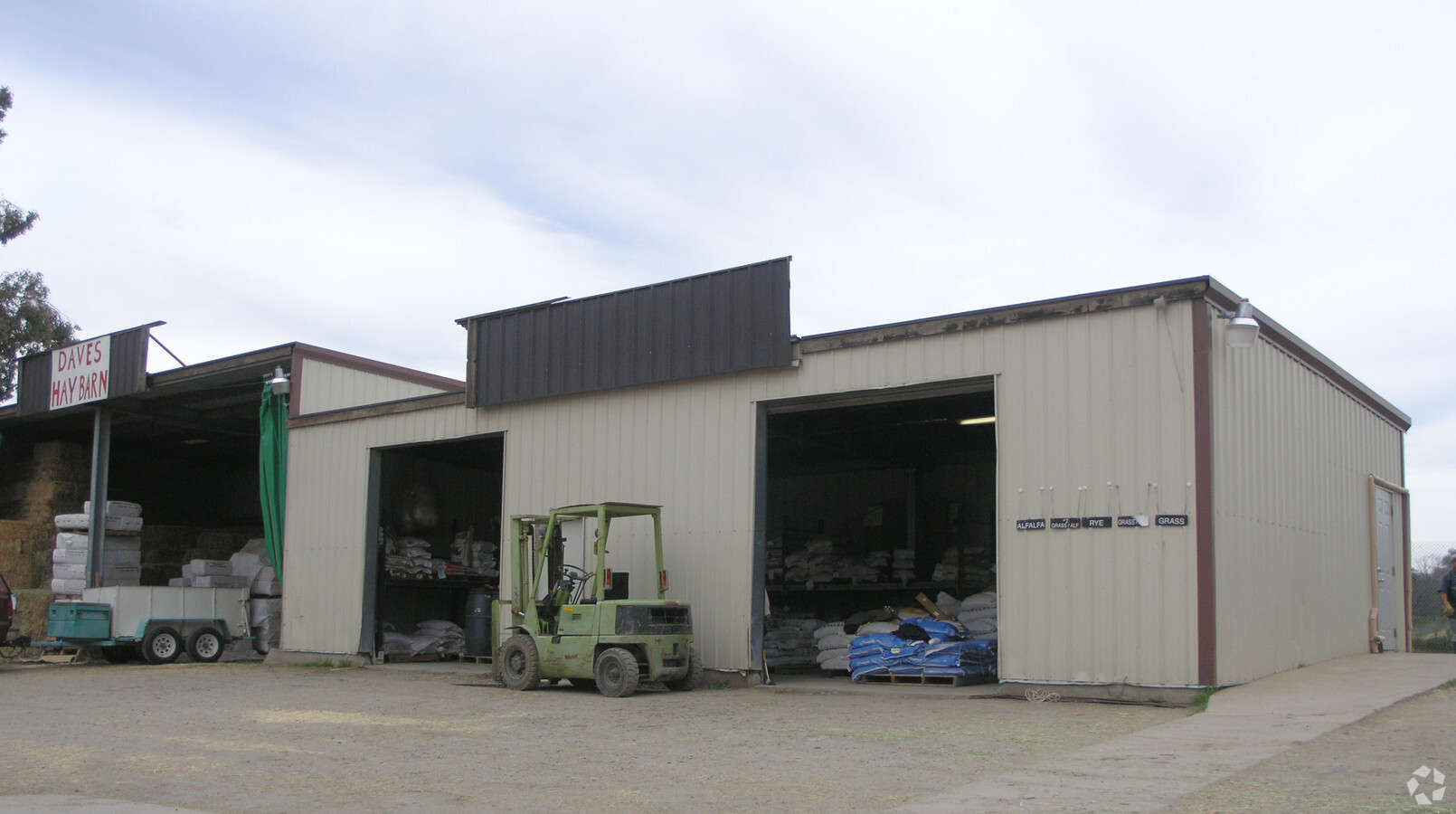
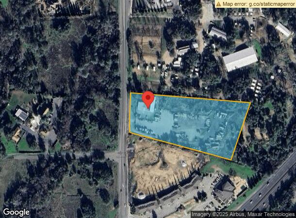
Property Record
3031 Penryn Rd, Penryn, CA 95663


NEARBY LISTINGS FOR SALE OR LEASE
Property Detail
3031 Penryn Rd
043-060-042
5 A PAR B PMOR 9 50
Commercialnec
Placer
X
California
06061C0960H
5 AC
2023
Roseville/Rocklin
2023
Sacramento
021204
Sacramento--Roseville--Arden-Arcade, CA
1,575 SF
DEMOGRAPHICS near 3031 Penryn Rd
1 Mile
3 Mile
5 Mile
2024 Total Population
1,540
15,091
52,328
2029 Population
1,637
16,043
56,291
Pop Growth 2024-2029
+ 6.30%
+ 6.31%
+ 7.57%
Average Age
42
43
44
2024 Total Households
545
5,408
19,420
HH Growth 2024-2029
+ 6.24%
+ 6.38%
+ 7.65%
Median Household Inc
$103,571
$113,570
$120,410
Avg Household Size
2.70
2.80
2.70
2024 Avg HH Vehicles
3.00
2.00
2.00
Median Home Value
$763,157
$754,905
$759,472
Median Year Built
1978
1978
1992
Nearby Places
- Restaurants
- Banks
- Shops
- Fitness
- Groceries
PUBLIC TRANSPORTATION
COMMUTER RAIL
Rocklin Amtrak Station (Capitol Corridor - Amtrak)
DRIVE
WALK
Distance
Rocklin Amtrak Station (Capitol Corridor - Amtrak)
8 min
5.5 mi
Auburn Amtrak (Capitol Corridor - Amtrak)
DRIVE
WALK
Distance
Auburn Amtrak (Capitol Corridor - Amtrak)
11 min
8.5 mi
AIRPORT
Sacramento International
DRIVE
WALK
Distance
Sacramento International
42 min
33.2 mi
Freight Ports
Port of Stockton
DRIVE
WALK
Distance
Port of Stockton
85 min
73.4 mi
Nearby Properties
Address
Land Use
TOTAL SIZE
Lot Size
Zoning
Address
Land Use
TOTAL SIZE
Lot Size
Zoning
159,029 SF
17.62 AC
Address
Land Use
TOTAL SIZE
Lot Size
Zoning
1,992 SF
44.99 AC
RAB100
Address
Land Use
TOTAL SIZE
Lot Size
Zoning
89,928 SF
6 AC
CG
Address
Land Use
TOTAL SIZE
Lot Size
Zoning
63,608 SF
5.20 AC
CG
Address
Land Use
TOTAL SIZE
Lot Size
Zoning
25,368 SF
1.08 AC
RH
Address
Land Use
TOTAL SIZE
Lot Size
Zoning
2,169 SF
25.40 AC
Address
Land Use
TOTAL SIZE
Lot Size
Zoning
26,750 SF
5.20 AC
CG
Address
Land Use
TOTAL SIZE
Lot Size
Zoning
12,259 SF
2.60 AC
RE
Address
Land Use
TOTAL SIZE
Lot Size
Zoning
30,209 SF
5.30 AC
C1UPDC
Address
Land Use
TOTAL SIZE
Lot Size
Zoning
61,024 SF
3 AC
IL
Address
Land Use
TOTAL SIZE
Lot Size
Zoning
46,310 SF
3.16 AC
Address
Land Use
TOTAL SIZE
Lot Size
Zoning
126,472 SF
11.40 AC
IL
Address
Land Use
TOTAL SIZE
Lot Size
Zoning
5,653 SF
1.60 AC
Address
Land Use
TOTAL SIZE
Lot Size
Zoning
8,036 SF
0.85 AC
CG
Address
Land Use
TOTAL SIZE
Lot Size
Zoning
26,352 SF
1.70 AC
ILT
Address
Land Use
TOTAL SIZE
Lot Size
Zoning
6,932 SF
11.80 AC
RAB100
Address
Land Use
TOTAL SIZE
Lot Size
Zoning
4,431 SF
1.40 AC
C1UPDC
Address
Land Use
TOTAL SIZE
Lot Size
Zoning
11,084 SF
10 AC
Address
Land Use
TOTAL SIZE
Lot Size
Zoning
26,072 SF
2.10 AC
Address
Land Use
TOTAL SIZE
Lot Size
Zoning
2,945 SF
1 AC
Address
Land Use
TOTAL SIZE
Lot Size
Zoning
7,047 SF
7.20 AC
Address
Land Use
TOTAL SIZE
Lot Size
Zoning
12,542 SF
3.60 AC
CG
Address
Land Use
TOTAL SIZE
Lot Size
Zoning
4.02 AC
IL
Address
Land Use
TOTAL SIZE
Lot Size
Zoning
10,000 SF
0.64 AC
IL
Address
Land Use
TOTAL SIZE
Lot Size
Zoning
13,031 SF
0.88 AC
CG
Address
Land Use
TOTAL SIZE
Lot Size
Zoning
10,935 SF
1.80 AC
CG
Address
Land Use
TOTAL SIZE
Lot Size
Zoning
10,047 SF
1.20 AC
CG
Address
Land Use
TOTAL SIZE
Lot Size
Zoning
12,600 SF
0.84 AC
CG
Address
Land Use
TOTAL SIZE
Lot Size
Zoning
13,578 SF
0.84 AC
C1UPDC
The World's #1 Commercial Real Estate Marketplace
Connect with us
© 2025 CoStar Group
The information above has been obtained from sources believed reliable. While we do not doubt its accuracy we have not verified it and make no guarantee, warranty or representation about it. It is your responsibility to independently confirm its accuracy and completeness. Any projections, opinions, assumptions, or estimates used are for example only and do not represent the current or future performance of the property. The value of this transaction to you depends on tax and other factors which should be evaluated by your tax, financial, and legal advisors. You and your advisors should conduct a careful, independent investigation of the property to determine to your satisfaction the suitability of the property for your needs.