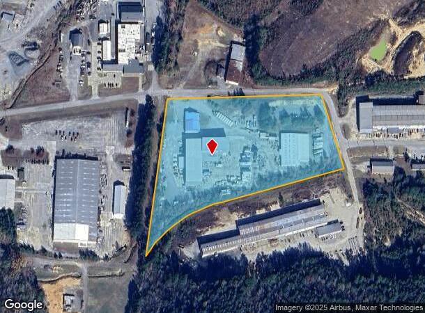
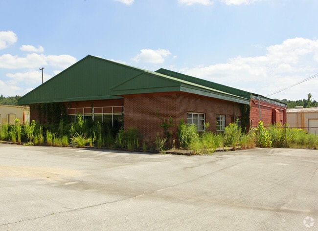
Property Record
304 Industrial Park Rd, Oneonta, AL 35121

NEARBY LISTINGS FOR SALE OR LEASE
-
-
View all Oneonta listings for sale on LoopNet.com
Property Detail
304 Industrial Park Rd
20-01-01-4-000-010.000
COM SE COR SE/4 N 579 W 1343 NW 522 ALG IND PARK DR POB NW NW 361 ALG DR WLY 718 SW 735 ALG RAILROAD ELY 1039 TO POB--
Officebuilding
Blount
X
Alabama
01009C0340F
8 AC
2025
Blount County
2024
Birmingham
050106
Birmingham-Hoover, AL
2,010 SF
DEMOGRAPHICS near 304 Industrial Park Rd
1 Mile
3 Mile
5 Mile
2024 Total Population
686
7,122
11,056
2029 Population
692
7,197
11,177
Pop Growth 2024-2029
+ 0.87%
+ 1.05%
+ 1.09%
Average Age
39
41
41
2024 Total Households
238
2,677
4,172
HH Growth 2024-2029
+ 0.84%
+ 1.05%
+ 1.10%
Median Household Inc
$31,041
$51,336
$48,716
Avg Household Size
2.60
2.50
2.50
2024 Avg HH Vehicles
1.00
2.00
2.00
Median Home Value
$85,858
$182,608
$181,696
Median Year Built
1962
1973
1975
Nearby Places
Map Layers
Map Styles
 Street
 Aerial
- Restaurants
- Banks
- Shops
- Fitness
- Groceries
PUBLIC TRANSPORTATION
AIRPORT
Birmingham-Shuttlesworth International
DRIVE
WALK
Distance
Birmingham-Shuttlesworth International
56 min
33.7 mi
Freight Ports
Port of Mobile
DRIVE
WALK
Distance
Port of Mobile
337 min
292.6 mi
Nearby Properties
Address
Land Use
TOTAL SIZE
Lot Size
Zoning
Address
Land Use
TOTAL SIZE
Lot Size
Zoning
45,720 SF
5.60 AC
Address
Land Use
TOTAL SIZE
Lot Size
Zoning
8,400 SF
3.03 AC
LI
Address
Land Use
TOTAL SIZE
Lot Size
Zoning
27,944 SF
1.08 AC
Address
Land Use
TOTAL SIZE
Lot Size
Zoning
22,168 SF
2.90 AC
Address
Land Use
TOTAL SIZE
Lot Size
Zoning
32,392 SF
1.34 AC
Address
Land Use
TOTAL SIZE
Lot Size
Zoning
23,245 SF
0.99 AC
Address
Land Use
TOTAL SIZE
Lot Size
Zoning
15,626 SF
0.36 AC
Address
Land Use
TOTAL SIZE
Lot Size
Zoning
99,004 SF
18 AC
Address
Land Use
TOTAL SIZE
Lot Size
Zoning
6,418 SF
8.10 AC
Address
Land Use
TOTAL SIZE
Lot Size
Zoning
45,000 SF
7.20 AC
Address
Land Use
TOTAL SIZE
Lot Size
Zoning
63,040 SF
6 AC
Address
Land Use
TOTAL SIZE
Lot Size
Zoning
10,000 SF
1.02 AC
Address
Land Use
TOTAL SIZE
Lot Size
Zoning
9,238 SF
1.71 AC
Address
Land Use
TOTAL SIZE
Lot Size
Zoning
15,928 SF
0.96 AC
Address
Land Use
TOTAL SIZE
Lot Size
Zoning
38,561 SF
3 AC
Address
Land Use
TOTAL SIZE
Lot Size
Zoning
49,700 SF
6.90 AC
Address
Land Use
TOTAL SIZE
Lot Size
Zoning
19,602 SF
4.70 AC
Address
Land Use
TOTAL SIZE
Lot Size
Zoning
14,800 SF
2.98 AC
Address
Land Use
TOTAL SIZE
Lot Size
Zoning
15,855 SF
1.22 AC
Address
Land Use
TOTAL SIZE
Lot Size
Zoning
Address
Land Use
TOTAL SIZE
Lot Size
Zoning
10,841 SF
0.40 AC
Address
Land Use
TOTAL SIZE
Lot Size
Zoning
4,560 SF
0.90 AC
Address
Land Use
TOTAL SIZE
Lot Size
Zoning
1,920 SF
3.50 AC
Address
Land Use
TOTAL SIZE
Lot Size
Zoning
6.70 AC
Address
Land Use
TOTAL SIZE
Lot Size
Zoning
11,600 SF
1.20 AC
Address
Land Use
TOTAL SIZE
Lot Size
Zoning
11,160 SF
0.62 AC
Address
Land Use
TOTAL SIZE
Lot Size
Zoning
12,152 SF
3 AC
Address
Land Use
TOTAL SIZE
Lot Size
Zoning
3,666 SF
1.20 AC
The World's #1 Commercial Real Estate Marketplace
Connect with us
© 2026 CoStar Group
The information above has been obtained from sources believed reliable. While we do not doubt its accuracy we have not verified it and make no guarantee, warranty or representation about it. It is your responsibility to independently confirm its accuracy and completeness. Any projections, opinions, assumptions, or estimates used are for example only and do not represent the current or future performance of the property. The value of this transaction to you depends on tax and other factors which should be evaluated by your tax, financial, and legal advisors. You and your advisors should conduct a careful, independent investigation of the property to determine to your satisfaction the suitability of the property for your needs.