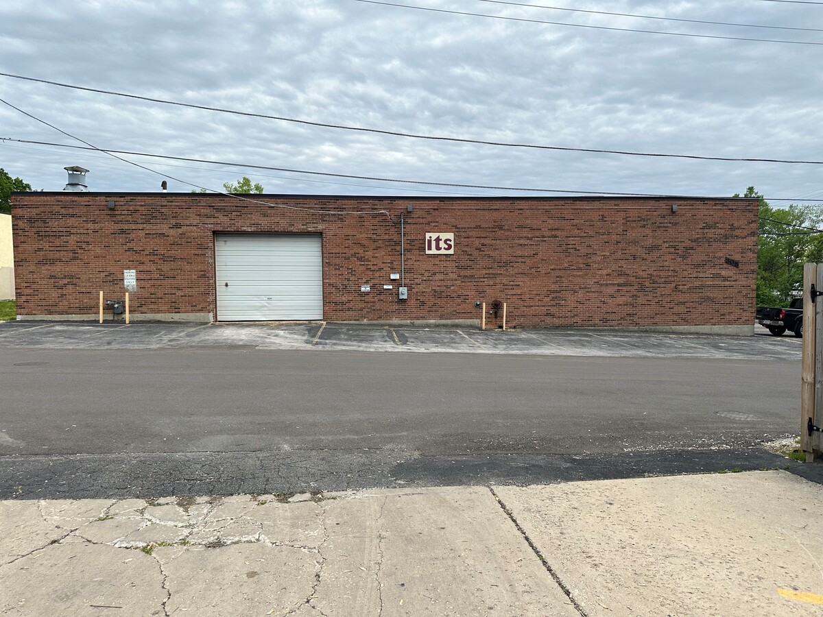
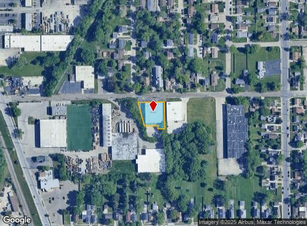
Property Record
305 Hankes Ave, Aurora, IL 60505

NEARBY LISTINGS FOR SALE OR LEASE
Property Detail
305 Hankes Ave
15-15-282-020
Industrial-Central Core
Industrialgeneral
PART NE 1/4 SEC 15-38-8 LOT DIMENSIONS: 0.54 ACRES APPROX LOT SQ FT 1 SUBDIVISION: INDUSTRIAL - CENTRAL CORE RANGE CODE: 001
X
Kane
17089C0343H
Illinois
2023
0.54 AC
2023
I-88 West
852907
Chicago
12,000 SF
Chicago-Naperville-Elgin, IL-IN-WI
DEMOGRAPHICS near 305 Hankes Ave
1 Mile
3 Mile
5 Mile
2024 Total Population
13,420
114,714
235,450
2029 Population
13,326
114,130
235,965
Pop Growth 2024-2029
(0.70%)
(0.51%)
+ 0.22%
Average Age
36
37
37
2024 Total Households
4,253
37,167
80,589
HH Growth 2024-2029
(0.52%)
(0.43%)
+ 0.24%
Median Household Inc
$64,713
$71,247
$83,639
Avg Household Size
3.00
2.90
2.80
2024 Avg HH Vehicles
2.00
2.00
2.00
Median Home Value
$163,985
$195,250
$239,481
Median Year Built
1956
1966
1985
Nearby Places
- Restaurants
- Banks
- Shops
- Fitness
- Groceries
PUBLIC TRANSPORTATION
COMMUTER RAIL
Aurora Station (Burlington Northern-Santa Fe Railway Line - Northeast Illinois Regional Commuter Railroad (Metra))
DRIVE
WALK
Distance
Aurora Station (Burlington Northern-Santa Fe Railway Line - Northeast Illinois Regional Commuter Railroad (Metra))
4 min
1.6 mi
Route 59 Station (Burlington Northern-Santa Fe Railway Line - Northeast Illinois Regional Commuter Railroad (Metra))
DRIVE
WALK
Distance
Route 59 Station (Burlington Northern-Santa Fe Railway Line - Northeast Illinois Regional Commuter Railroad (Metra))
13 min
5.5 mi
AIRPORT
Chicago Midway International
DRIVE
WALK
Distance
Chicago Midway International
53 min
34.6 mi
Chicago O'Hare International
DRIVE
WALK
Distance
Chicago O'Hare International
52 min
35.5 mi
Freight Ports
Port Milwaukee
DRIVE
WALK
Distance
Port Milwaukee
133 min
107.2 mi
Nearby Properties
Address
Land Use
TOTAL SIZE
Lot Size
Zoning
Address
Land Use
TOTAL SIZE
Lot Size
Zoning
41.29 AC
Address
Land Use
TOTAL SIZE
Lot Size
Zoning
27.18 AC
Address
Land Use
TOTAL SIZE
Lot Size
Zoning
10.62 AC
Address
Land Use
TOTAL SIZE
Lot Size
Zoning
25.58 AC
Address
Land Use
TOTAL SIZE
Lot Size
Zoning
692,020 SF
33.90 AC
Address
Land Use
TOTAL SIZE
Lot Size
Zoning
Address
Land Use
TOTAL SIZE
Lot Size
Zoning
581,960 SF
17.63 AC
Address
Land Use
TOTAL SIZE
Lot Size
Zoning
20.56 AC
Address
Land Use
TOTAL SIZE
Lot Size
Zoning
607,706 SF
16.55 AC
Address
Land Use
TOTAL SIZE
Lot Size
Zoning
622,072 SF
6.04 AC
Address
Land Use
TOTAL SIZE
Lot Size
Zoning
521,922 SF
19.87 AC
Address
Land Use
TOTAL SIZE
Lot Size
Zoning
Address
Land Use
TOTAL SIZE
Lot Size
Zoning
Address
Land Use
TOTAL SIZE
Lot Size
Zoning
25.07 AC
Address
Land Use
TOTAL SIZE
Lot Size
Zoning
255,500 SF
17.64 AC
Address
Land Use
TOTAL SIZE
Lot Size
Zoning
11.79 AC
Address
Land Use
TOTAL SIZE
Lot Size
Zoning
320,874 SF
1.49 AC
Address
Land Use
TOTAL SIZE
Lot Size
Zoning
307,443 SF
22.99 AC
I
Address
Land Use
TOTAL SIZE
Lot Size
Zoning
Address
Land Use
TOTAL SIZE
Lot Size
Zoning
383,948 SF
17.92 AC
Address
Land Use
TOTAL SIZE
Lot Size
Zoning
17.42 AC
Address
Land Use
TOTAL SIZE
Lot Size
Zoning
100,340 SF
1.80 AC
Address
Land Use
TOTAL SIZE
Lot Size
Zoning
317,815 SF
21.29 AC
Address
Land Use
TOTAL SIZE
Lot Size
Zoning
12.80 AC
Address
Land Use
TOTAL SIZE
Lot Size
Zoning
15.58 AC
Address
Land Use
TOTAL SIZE
Lot Size
Zoning
289,366 SF
14.53 AC
Address
Land Use
TOTAL SIZE
Lot Size
Zoning
224,624 SF
8.35 AC
Address
Land Use
TOTAL SIZE
Lot Size
Zoning
181,268 SF
7.62 AC
Address
Land Use
TOTAL SIZE
Lot Size
Zoning
173,240 SF
0.90 AC
Address
Land Use
TOTAL SIZE
Lot Size
Zoning
73,880 SF
0.75 AC
The World's #1 Commercial Real Estate Marketplace
Connect with us
© 2025 CoStar Group
The information above has been obtained from sources believed reliable. While we do not doubt its accuracy we have not verified it and make no guarantee, warranty or representation about it. It is your responsibility to independently confirm its accuracy and completeness. Any projections, opinions, assumptions, or estimates used are for example only and do not represent the current or future performance of the property. The value of this transaction to you depends on tax and other factors which should be evaluated by your tax, financial, and legal advisors. You and your advisors should conduct a careful, independent investigation of the property to determine to your satisfaction the suitability of the property for your needs.