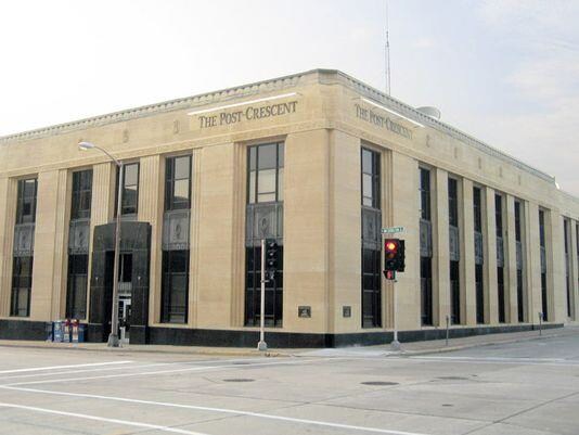
Property Record
N Superior St, Appleton, WI 54911

NEARBY LISTINGS FOR SALE OR LEASE
Property Detail
N Superior St
Appleton, WI
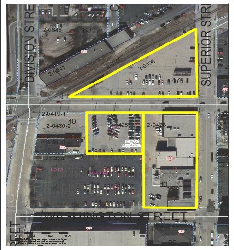
Second Ward Plat
31-2-0498-00
SECOND WARD PLAT 2WD PRT OF C&NW RY R/W IN NE1/4 OF SW1/4 SEC 26 T21N R17E AND ALL OF LOTS 1 AND 2 BLK 47
Commercialnec
Outagamie
X
Wisconsin
55087C0318D
1-2
2023
1 AC
2023
Outagamie County
011300
Green Bay
DEMOGRAPHICS near N Superior St
1 Mile
3 Mile
5 Mile
2024 Total Population
18,555
98,104
168,417
2029 Population
19,304
101,429
173,316
Pop Growth 2024-2029
+ 4.04%
+ 3.39%
+ 2.91%
Average Age
37
39
40
2024 Total Households
7,582
40,997
69,798
HH Growth 2024-2029
+ 4.37%
+ 3.35%
+ 2.88%
Median Household Inc
$55,784
$65,190
$70,211
Avg Household Size
2.10
2.30
2.30
2024 Avg HH Vehicles
2.00
2.00
2.00
Median Home Value
$161,450
$181,652
$199,670
Median Year Built
1947
1973
1979
Nearby Places
- Restaurants
- Banks
- Shops
- Fitness
- Groceries
PUBLIC TRANSPORTATION
AIRPORT
Appleton International
DRIVE
WALK
Distance
Appleton International
17 min
8.6 mi
Green Bay/Austin Straubel International
DRIVE
WALK
Distance
Green Bay/Austin Straubel International
34 min
25.8 mi
Freight Ports
Port Milwaukee
DRIVE
WALK
Distance
Port Milwaukee
130 min
110.2 mi
SALE & LEASE HISTORY
LISTING DATE
SALE/LEASE

May 25, 2017
For Sale
May 14, 2018
For Sale
Nearby Properties
Address
Land Use
TOTAL SIZE
Lot Size
Zoning
Address
Land Use
TOTAL SIZE
Lot Size
Zoning
154,889 SF
1 AC
C2
Address
Land Use
TOTAL SIZE
Lot Size
Zoning
500,700 SF
47.17 AC
Address
Land Use
TOTAL SIZE
Lot Size
Zoning
189,107 SF
13.37 AC
Address
Land Use
TOTAL SIZE
Lot Size
Zoning
3.42 AC
PDC2
Address
Land Use
TOTAL SIZE
Lot Size
Zoning
84,620 SF
92.18 AC
C2
Address
Land Use
TOTAL SIZE
Lot Size
Zoning
20.37 AC
PDC2
Address
Land Use
TOTAL SIZE
Lot Size
Zoning
70,136 SF
6.34 AC
C2
Address
Land Use
TOTAL SIZE
Lot Size
Zoning
65,818 SF
8.01 AC
C2
Address
Land Use
TOTAL SIZE
Lot Size
Zoning
29,742 SF
5.95 AC
R3
Address
Land Use
TOTAL SIZE
Lot Size
Zoning
6.02 AC
Address
Land Use
TOTAL SIZE
Lot Size
Zoning
278,801 SF
20.94 AC
Address
Land Use
TOTAL SIZE
Lot Size
Zoning
6.58 AC
M1
Address
Land Use
TOTAL SIZE
Lot Size
Zoning
194,573 SF
19.99 AC
Address
Land Use
TOTAL SIZE
Lot Size
Zoning
Address
Land Use
TOTAL SIZE
Lot Size
Zoning
247,520 SF
13.68 AC
M1
Address
Land Use
TOTAL SIZE
Lot Size
Zoning
53,321 SF
2.50 AC
CBD
Address
Land Use
TOTAL SIZE
Lot Size
Zoning
44,164 SF
0.62 AC
CBD
Address
Land Use
TOTAL SIZE
Lot Size
Zoning
40,560 SF
6.66 AC
R3
Address
Land Use
TOTAL SIZE
Lot Size
Zoning
107,202 SF
39.98 AC
C2
Address
Land Use
TOTAL SIZE
Lot Size
Zoning
66,504 SF
5.25 AC
C2
Address
Land Use
TOTAL SIZE
Lot Size
Zoning
14,024 SF
9.34 AC
PDR3
Address
Land Use
TOTAL SIZE
Lot Size
Zoning
Address
Land Use
TOTAL SIZE
Lot Size
Zoning
67,817 SF
21.35 AC
C2
Address
Land Use
TOTAL SIZE
Lot Size
Zoning
20.22 AC
M1
Address
Land Use
TOTAL SIZE
Lot Size
Zoning
13,994 SF
8.13 AC
R3
Address
Land Use
TOTAL SIZE
Lot Size
Zoning
5,394 SF
0.30 AC
CBD
Address
Land Use
TOTAL SIZE
Lot Size
Zoning
62,673 SF
3.19 AC
PDC2
Address
Land Use
TOTAL SIZE
Lot Size
Zoning
21,540 SF
0.79 AC
CBD
Address
Land Use
TOTAL SIZE
Lot Size
Zoning
25,705 SF
2.03 AC
PDR3
Address
Land Use
TOTAL SIZE
Lot Size
Zoning
83,926 SF
7.35 AC
C2
The World's #1 Commercial Real Estate Marketplace
Connect with us
© 2025 CoStar Group
The information above has been obtained from sources believed reliable. While we do not doubt its accuracy we have not verified it and make no guarantee, warranty or representation about it. It is your responsibility to independently confirm its accuracy and completeness. Any projections, opinions, assumptions, or estimates used are for example only and do not represent the current or future performance of the property. The value of this transaction to you depends on tax and other factors which should be evaluated by your tax, financial, and legal advisors. You and your advisors should conduct a careful, independent investigation of the property to determine to your satisfaction the suitability of the property for your needs.