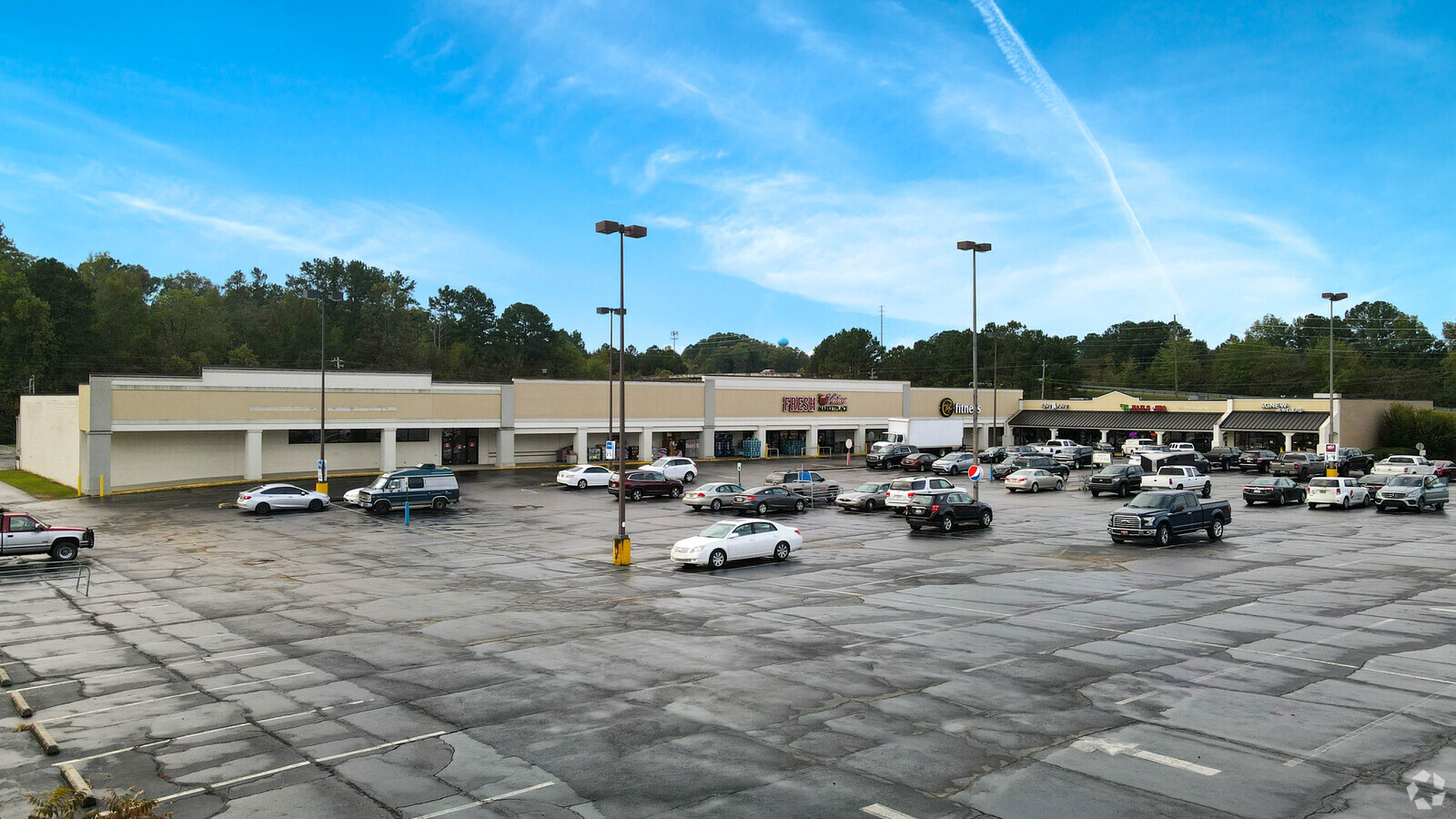
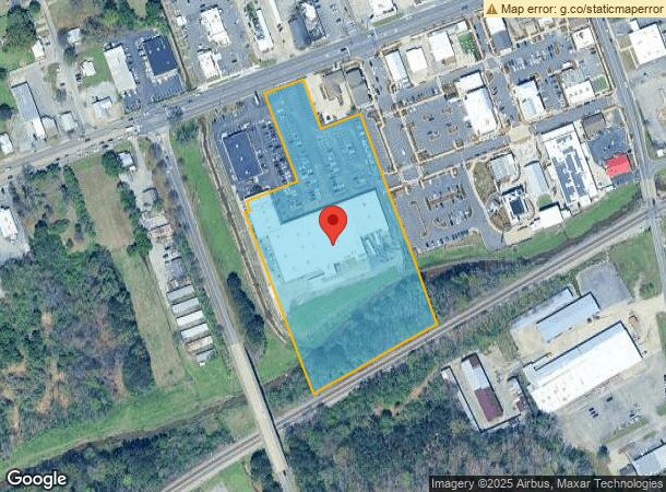
Property Record
307 Main St, Trussville, AL 35173

NEARBY LISTINGS FOR SALE OR LEASE
Property Detail
307 Main St
Birmingham-Hoover, AL
Village Truss Out Prcl 2
12-00-26-1-004-006.000
COM AT INTER OF W R/W MORROW ST & S R/W OF US HWY 11 TH SW 539.4 FT TO POB TH SE 150 FT TH NE 125 FT TH SE 655.9 FT TH SWLY 425 FT TH NWLY 570 FT TH NE 22.3 FT TH NWLY 20 FT TH NE 163.7 FT TH NWLY 285 FT TH NELY 125 FT TO POB
Commercialnec
Jefferson
AE
Alabama
01073C0426J
1
2023
6.60 AC
2024
Trussville
0111084005
Birmingham
58,192 SF
DEMOGRAPHICS near 307 Main St
1 Mile
3 Mile
5 Mile
2024 Total Population
5,625
24,938
69,285
2029 Population
5,433
24,118
67,710
Pop Growth 2024-2029
(3.41%)
(3.29%)
(2.27%)
Average Age
40
39
38
2024 Total Households
2,144
9,367
25,771
HH Growth 2024-2029
(3.50%)
(3.39%)
(2.36%)
Median Household Inc
$90,407
$77,898
$63,276
Avg Household Size
2.50
2.60
2.60
2024 Avg HH Vehicles
2.00
2.00
2.00
Median Home Value
$290,136
$242,635
$184,545
Median Year Built
1991
1989
1981
Nearby Places
- Restaurants
- Banks
- Shops
- Fitness
- Groceries
PUBLIC TRANSPORTATION
AIRPORT
Birmingham-Shuttlesworth International
DRIVE
WALK
Distance
Birmingham-Shuttlesworth International
18 min
11.8 mi
Freight Ports
Port of Mobile
DRIVE
WALK
Distance
Port of Mobile
292 min
266.2 mi
Nearby Properties
Address
Land Use
TOTAL SIZE
Lot Size
Zoning
Address
Land Use
TOTAL SIZE
Lot Size
Zoning
326,294 SF
25.99 AC
R4&U
Address
Land Use
TOTAL SIZE
Lot Size
Zoning
346,184 SF
21.75 AC
I2
Address
Land Use
TOTAL SIZE
Lot Size
Zoning
155,845 SF
17 AC
C2
Address
Land Use
TOTAL SIZE
Lot Size
Zoning
204,463 SF
32.90 AC
PUD
Address
Land Use
TOTAL SIZE
Lot Size
Zoning
2,573,547 SF
112 AC
I2
Address
Land Use
TOTAL SIZE
Lot Size
Zoning
144,921 SF
9 AC
R4
Address
Land Use
TOTAL SIZE
Lot Size
Zoning
87,863 SF
13.20 AC
PUD
Address
Land Use
TOTAL SIZE
Lot Size
Zoning
204,269 SF
17.94 AC
PUD
Address
Land Use
TOTAL SIZE
Lot Size
Zoning
94,262 SF
17.30 AC
C-2
Address
Land Use
TOTAL SIZE
Lot Size
Zoning
134,442 SF
26 AC
PUD
Address
Land Use
TOTAL SIZE
Lot Size
Zoning
176,232 SF
5.20 AC
C2
Address
Land Use
TOTAL SIZE
Lot Size
Zoning
110,776 SF
11.10 AC
C2
Address
Land Use
TOTAL SIZE
Lot Size
Zoning
34,169 SF
2.56 AC
QC2
Address
Land Use
TOTAL SIZE
Lot Size
Zoning
53,864 SF
6.58 AC
C2
Address
Land Use
TOTAL SIZE
Lot Size
Zoning
49,858 SF
7.30 AC
C4
Address
Land Use
TOTAL SIZE
Lot Size
Zoning
74,218 SF
4.50 AC
C2
Address
Land Use
TOTAL SIZE
Lot Size
Zoning
62,944 SF
8.44 AC
C1
Address
Land Use
TOTAL SIZE
Lot Size
Zoning
97,652 SF
6.20 AC
C2
Address
Land Use
TOTAL SIZE
Lot Size
Zoning
89,761 SF
11 AC
PUD
Address
Land Use
TOTAL SIZE
Lot Size
Zoning
122,397 SF
13.13 AC
C1
Address
Land Use
TOTAL SIZE
Lot Size
Zoning
40,011 SF
2.05 AC
C1
Address
Land Use
TOTAL SIZE
Lot Size
Zoning
101,606 SF
4.46 AC
C-2
Address
Land Use
TOTAL SIZE
Lot Size
Zoning
87,142 SF
10.80 AC
C-2
Address
Land Use
TOTAL SIZE
Lot Size
Zoning
94,370 SF
6.07 AC
C2
Address
Land Use
TOTAL SIZE
Lot Size
Zoning
29,422 SF
5.31 AC
C2
Address
Land Use
TOTAL SIZE
Lot Size
Zoning
55,000 SF
7.10 AC
C2&I
Address
Land Use
TOTAL SIZE
Lot Size
Zoning
67,270 SF
9.70 AC
C2
Address
Land Use
TOTAL SIZE
Lot Size
Zoning
11,872 SF
3.38 AC
QC2
Address
Land Use
TOTAL SIZE
Lot Size
Zoning
28,068 SF
16.75 AC
C-2
Address
Land Use
TOTAL SIZE
Lot Size
Zoning
48,483 SF
5.05 AC
C1
The World's #1 Commercial Real Estate Marketplace
Connect with us
© 2025 CoStar Group
The information above has been obtained from sources believed reliable. While we do not doubt its accuracy we have not verified it and make no guarantee, warranty or representation about it. It is your responsibility to independently confirm its accuracy and completeness. Any projections, opinions, assumptions, or estimates used are for example only and do not represent the current or future performance of the property. The value of this transaction to you depends on tax and other factors which should be evaluated by your tax, financial, and legal advisors. You and your advisors should conduct a careful, independent investigation of the property to determine to your satisfaction the suitability of the property for your needs.