Property Record
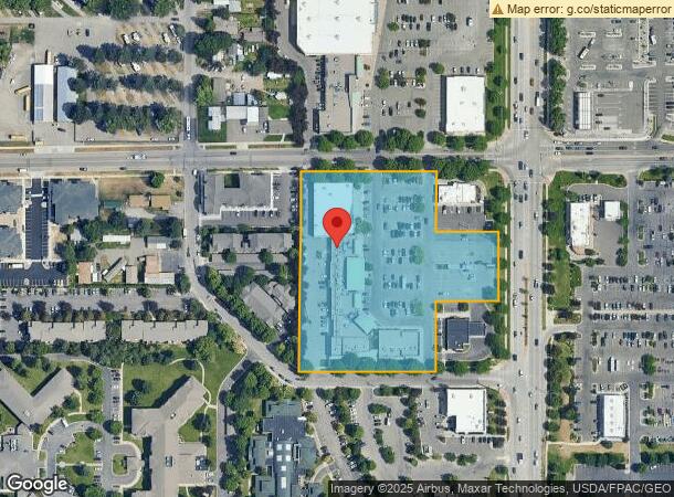
3085 N Reserve St, Missoula, MT 59808
NEARBY LISTINGS FOR SALE OR LEASE
Property Detail
3085 N Reserve St
Missoula, MT
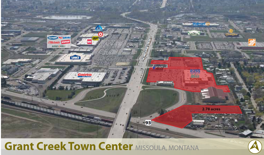
Grant Creek Town Center
04-2200-07-4-04-01-0000
GRANT CREEK TOWN CENTER - LOTS 1,3 & 4, S07, T13 N, R19 W, LOT 1A, LOTS 1,3 & 4
Commercialnec
Missoula
X
Montana
30063C1195E
1a
2023
4.27 AC
2024
Missoula
000206
Other Market Areas
37,967 SF
DEMOGRAPHICS near 3085 N Reserve St
1 Mile
3 Mile
5 Mile
2024 Total Population
6,866
47,183
88,443
2029 Population
7,607
51,298
95,787
Pop Growth 2024-2029
+ 10.79%
+ 8.72%
+ 8.30%
Average Age
39
38
39
2024 Total Households
3,572
22,629
39,442
HH Growth 2024-2029
+ 10.89%
+ 8.87%
+ 8.48%
Median Household Inc
$48,600
$53,811
$62,588
Avg Household Size
1.80
2.00
2.10
2024 Avg HH Vehicles
1.00
2.00
2.00
Median Home Value
$327,385
$335,733
$373,511
Median Year Built
2010
1994
1984
Nearby Places
- Restaurants
- Banks
- Shops
- Fitness
- Groceries
PUBLIC TRANSPORTATION
AIRPORT
Missoula Montana
DRIVE
WALK
Distance
Missoula Montana
8 min
3.5 mi
Freight Ports
Port of Everett
DRIVE
WALK
Distance
Port of Everett
547 min
496.5 mi
Nearby Properties
Address
Land Use
TOTAL SIZE
Lot Size
Zoning
Address
Land Use
TOTAL SIZE
Lot Size
Zoning
340,369 SF
6.14 AC
1
Address
Land Use
TOTAL SIZE
Lot Size
Zoning
252,171 SF
8.63 AC
Address
Land Use
TOTAL SIZE
Lot Size
Zoning
352,710 SF
Address
Land Use
TOTAL SIZE
Lot Size
Zoning
187,680 SF
10.06 AC
Address
Land Use
TOTAL SIZE
Lot Size
Zoning
157,658 SF
2.04 AC
Address
Land Use
TOTAL SIZE
Lot Size
Zoning
179,712 SF
8.71 AC
Address
Land Use
TOTAL SIZE
Lot Size
Zoning
130,966 SF
1.06 AC
6
Address
Land Use
TOTAL SIZE
Lot Size
Zoning
61,762 SF
8.48 AC
Address
Land Use
TOTAL SIZE
Lot Size
Zoning
175,964 SF
5.01 AC
Address
Land Use
TOTAL SIZE
Lot Size
Zoning
61,800 SF
6.11 AC
Address
Land Use
TOTAL SIZE
Lot Size
Zoning
35,884 SF
7.40 AC
6
Address
Land Use
TOTAL SIZE
Lot Size
Zoning
125,976 SF
10.64 AC
1
Address
Land Use
TOTAL SIZE
Lot Size
Zoning
128,120 SF
1.15 AC
5
Address
Land Use
TOTAL SIZE
Lot Size
Zoning
205,960 SF
18.52 AC
Address
Land Use
TOTAL SIZE
Lot Size
Zoning
73,710 SF
12.42 AC
Address
Land Use
TOTAL SIZE
Lot Size
Zoning
98,144 SF
7.50 AC
6
Address
Land Use
TOTAL SIZE
Lot Size
Zoning
104,592 SF
3.36 AC
6
Address
Land Use
TOTAL SIZE
Lot Size
Zoning
92,743 SF
0.68 AC
6
Address
Land Use
TOTAL SIZE
Lot Size
Zoning
34,404 SF
10.25 AC
6
Address
Land Use
TOTAL SIZE
Lot Size
Zoning
102,818 SF
10.92 AC
7
Address
Land Use
TOTAL SIZE
Lot Size
Zoning
73,143 SF
6.54 AC
7
Address
Land Use
TOTAL SIZE
Lot Size
Zoning
133,210 SF
11.25 AC
Address
Land Use
TOTAL SIZE
Lot Size
Zoning
121,393 SF
12.23 AC
8
Address
Land Use
TOTAL SIZE
Lot Size
Zoning
121,881 SF
10.57 AC
7
Address
Land Use
TOTAL SIZE
Lot Size
Zoning
130,275 SF
10.17 AC
7
Address
Land Use
TOTAL SIZE
Lot Size
Zoning
66,900 SF
0.25 AC
6
Address
Land Use
TOTAL SIZE
Lot Size
Zoning
160,516 SF
13.50 AC
Address
Land Use
TOTAL SIZE
Lot Size
Zoning
105,004 SF
3.45 AC
Address
Land Use
TOTAL SIZE
Lot Size
Zoning
51,891 SF
1.61 AC
7
Address
Land Use
TOTAL SIZE
Lot Size
Zoning
113,653 SF
2.66 AC
The World's #1 Commercial Real Estate Marketplace
Connect with us
© 2025 CoStar Group
The information above has been obtained from sources believed reliable. While we do not doubt its accuracy we have not verified it and make no guarantee, warranty or representation about it. It is your responsibility to independently confirm its accuracy and completeness. Any projections, opinions, assumptions, or estimates used are for example only and do not represent the current or future performance of the property. The value of this transaction to you depends on tax and other factors which should be evaluated by your tax, financial, and legal advisors. You and your advisors should conduct a careful, independent investigation of the property to determine to your satisfaction the suitability of the property for your needs.