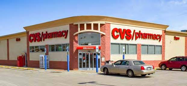
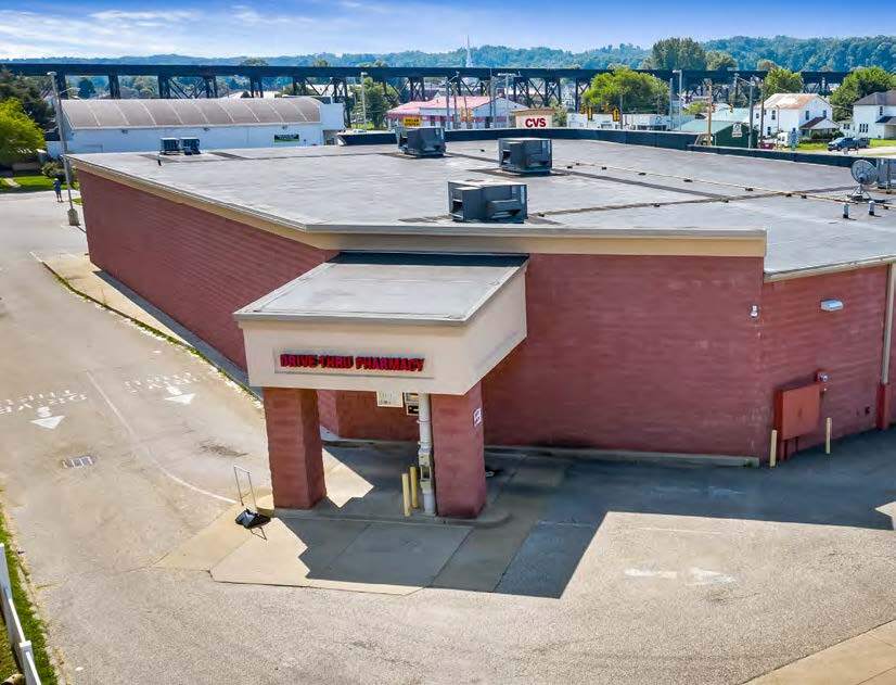
Property Record
310 15Th St, Kenova, WV 25530


NEARBY LISTINGS FOR SALE OR LEASE
Property Detail
310 15Th St
Huntington-Ashland, WV-KY-OH
Hover Asbury Subdivision
07-9-01480000
143 1.2225 AC (SURVEY)
Storebuilding
Wayne
X
West Virginia
54099C0015D
1.22 AC
2024
Wayne County
2024
Huntington/Ashland
020400
DEMOGRAPHICS near 310 15Th St
1 Mile
3 Mile
5 Mile
2024 Total Population
4,323
14,620
37,655
2029 Population
4,176
14,195
36,734
Pop Growth 2024-2029
(3.40%)
(2.91%)
(2.45%)
Average Age
42
43
42
2024 Total Households
1,894
6,097
15,755
HH Growth 2024-2029
(3.12%)
(2.79%)
(2.32%)
Median Household Inc
$40,027
$45,979
$49,065
Avg Household Size
2.20
2.30
2.30
2024 Avg HH Vehicles
2.00
2.00
2.00
Median Home Value
$103,199
$116,656
$122,986
Median Year Built
1961
1970
1969
Nearby Places
- Restaurants
- Banks
- Shops
- Fitness
- Groceries
PUBLIC TRANSPORTATION
COMMUTER RAIL
Ashland Amtrak Station (Cardinal - Amtrak)
DRIVE
WALK
Distance
Ashland Amtrak Station (Cardinal - Amtrak)
12 min
7.5 mi
AIRPORT
Tri-State/Milton J Ferguson Field
DRIVE
WALK
Distance
Tri-State/Milton J Ferguson Field
9 min
4.7 mi
Freight Ports
Port of Toledo
DRIVE
WALK
Distance
Port of Toledo
345 min
264.9 mi
SALE & LEASE HISTORY
LISTING DATE
SALE/LEASE

Aug 10, 2021
For Sale
Nearby Properties
Address
Land Use
TOTAL SIZE
Lot Size
Zoning
Address
Land Use
TOTAL SIZE
Lot Size
Zoning
492.60 AC
Address
Land Use
TOTAL SIZE
Lot Size
Zoning
0.69 AC
Z02
Address
Land Use
TOTAL SIZE
Lot Size
Zoning
2.83 AC
Address
Land Use
TOTAL SIZE
Lot Size
Zoning
123,920 SF
6.81 AC
Address
Land Use
TOTAL SIZE
Lot Size
Zoning
348,219 SF
12 AC
Address
Land Use
TOTAL SIZE
Lot Size
Zoning
8,364 SF
3 AC
Z02
Address
Land Use
TOTAL SIZE
Lot Size
Zoning
Address
Land Use
TOTAL SIZE
Lot Size
Zoning
126,716 SF
10.60 AC
Address
Land Use
TOTAL SIZE
Lot Size
Zoning
33.45 AC
COMMERCIAL
Address
Land Use
TOTAL SIZE
Lot Size
Zoning
27,084 SF
3.73 AC
Address
Land Use
TOTAL SIZE
Lot Size
Zoning
68,160 SF
0.87 AC
Z01
Address
Land Use
TOTAL SIZE
Lot Size
Zoning
32,400 SF
3 AC
Address
Land Use
TOTAL SIZE
Lot Size
Zoning
132,113 SF
4.38 AC
Address
Land Use
TOTAL SIZE
Lot Size
Zoning
3.94 AC
COMMERCIAL
Address
Land Use
TOTAL SIZE
Lot Size
Zoning
43.18 AC
COMMERCIAL
Address
Land Use
TOTAL SIZE
Lot Size
Zoning
0.87 AC
RESIDENTIA
Address
Land Use
TOTAL SIZE
Lot Size
Zoning
0.26 AC
Z02
Address
Land Use
TOTAL SIZE
Lot Size
Zoning
19.68 AC
Address
Land Use
TOTAL SIZE
Lot Size
Zoning
2.78 AC
Z01
Address
Land Use
TOTAL SIZE
Lot Size
Zoning
60,000 SF
5 AC
Address
Land Use
TOTAL SIZE
Lot Size
Zoning
12.14 AC
Address
Land Use
TOTAL SIZE
Lot Size
Zoning
3.84 AC
OTHER
Address
Land Use
TOTAL SIZE
Lot Size
Zoning
2.20 AC
Address
Land Use
TOTAL SIZE
Lot Size
Zoning
87,560 SF
6.50 AC
Address
Land Use
TOTAL SIZE
Lot Size
Zoning
0.10 AC
OTHER
Address
Land Use
TOTAL SIZE
Lot Size
Zoning
37,248 SF
2.12 AC
Address
Land Use
TOTAL SIZE
Lot Size
Zoning
0.82 AC
COMMERCIAL
Address
Land Use
TOTAL SIZE
Lot Size
Zoning
1.80 AC
Address
Land Use
TOTAL SIZE
Lot Size
Zoning
0.33 AC
OTHER
Address
Land Use
TOTAL SIZE
Lot Size
Zoning
5 AC
The World's #1 Commercial Real Estate Marketplace
Connect with us
© 2025 CoStar Group
The information above has been obtained from sources believed reliable. While we do not doubt its accuracy we have not verified it and make no guarantee, warranty or representation about it. It is your responsibility to independently confirm its accuracy and completeness. Any projections, opinions, assumptions, or estimates used are for example only and do not represent the current or future performance of the property. The value of this transaction to you depends on tax and other factors which should be evaluated by your tax, financial, and legal advisors. You and your advisors should conduct a careful, independent investigation of the property to determine to your satisfaction the suitability of the property for your needs.