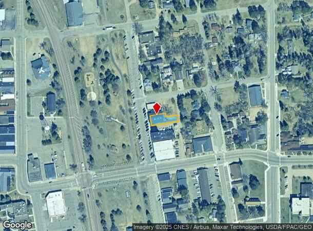
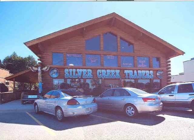
Property Record
31038 Government Dr, Pequot Lakes, MN 56472

NEARBY LISTINGS FOR SALE OR LEASE
Property Detail
31038 Government Dr
Brainerd, MN
Coles Plat Of Pequot
29102003005Z009
LOT 5 BLOCK 3 EXCEPT N 18 FT OF THE E 60 FT & ALSO INCLUDING THE N. 2 FT OF LOT 6 BLOCK 3
Storebuilding
Crow Wing
X
Minnesota
27035C0275C
5,6
2024
0.14 AC
2024
Minnesota Central Area
950401
Other Market Areas
6,600 SF
DEMOGRAPHICS near 31038 Government Dr
1 Mile
3 Mile
5 Mile
2024 Total Population
1,598
2,884
7,508
2029 Population
1,708
3,096
8,153
Pop Growth 2024-2029
+ 6.88%
+ 7.35%
+ 8.59%
Average Age
41
41
43
2024 Total Households
695
1,213
3,071
HH Growth 2024-2029
+ 6.76%
+ 7.17%
+ 8.43%
Median Household Inc
$58,471
$61,442
$68,129
Avg Household Size
2.20
2.30
2.40
2024 Avg HH Vehicles
2.00
2.00
2.00
Median Home Value
$192,161
$222,059
$275,588
Median Year Built
1993
1993
1994
Nearby Places
- Restaurants
- Banks
- Shops
- Fitness
- Groceries
SALE & LEASE HISTORY
LISTING DATE
SALE/LEASE

Jan 03, 2017
For Lease
Nearby Properties
Address
Land Use
TOTAL SIZE
Lot Size
Zoning
Address
Land Use
TOTAL SIZE
Lot Size
Zoning
247,491 SF
40 AC
Address
Land Use
TOTAL SIZE
Lot Size
Zoning
8.06 AC
Address
Land Use
TOTAL SIZE
Lot Size
Zoning
13,020 SF
21.08 AC
Address
Land Use
TOTAL SIZE
Lot Size
Zoning
35,036 SF
14.17 AC
Address
Land Use
TOTAL SIZE
Lot Size
Zoning
48,490 SF
39.82 AC
Address
Land Use
TOTAL SIZE
Lot Size
Zoning
5.46 AC
Address
Land Use
TOTAL SIZE
Lot Size
Zoning
1,456 SF
5.92 AC
Address
Land Use
TOTAL SIZE
Lot Size
Zoning
75,910 SF
19.12 AC
Address
Land Use
TOTAL SIZE
Lot Size
Zoning
14,855 SF
6.09 AC
Address
Land Use
TOTAL SIZE
Lot Size
Zoning
58,500 SF
7.05 AC
Address
Land Use
TOTAL SIZE
Lot Size
Zoning
24,960 SF
5.36 AC
Address
Land Use
TOTAL SIZE
Lot Size
Zoning
22,380 SF
0.86 AC
Address
Land Use
TOTAL SIZE
Lot Size
Zoning
20.18 AC
Address
Land Use
TOTAL SIZE
Lot Size
Zoning
450 SF
4.33 AC
Address
Land Use
TOTAL SIZE
Lot Size
Zoning
8,000 SF
5.06 AC
Address
Land Use
TOTAL SIZE
Lot Size
Zoning
23,812 SF
5.25 AC
Address
Land Use
TOTAL SIZE
Lot Size
Zoning
2,812 SF
160.83 AC
Address
Land Use
TOTAL SIZE
Lot Size
Zoning
4,760 SF
194.48 AC
Address
Land Use
TOTAL SIZE
Lot Size
Zoning
14,400 SF
5.39 AC
Address
Land Use
TOTAL SIZE
Lot Size
Zoning
7,782 SF
10.62 AC
Address
Land Use
TOTAL SIZE
Lot Size
Zoning
11,280 SF
2.12 AC
Address
Land Use
TOTAL SIZE
Lot Size
Zoning
18,720 SF
4.91 AC
Address
Land Use
TOTAL SIZE
Lot Size
Zoning
8,180 SF
1.80 AC
Address
Land Use
TOTAL SIZE
Lot Size
Zoning
3,000 SF
5.87 AC
Address
Land Use
TOTAL SIZE
Lot Size
Zoning
6,574 SF
6.85 AC
Address
Land Use
TOTAL SIZE
Lot Size
Zoning
9,504 SF
0.52 AC
Address
Land Use
TOTAL SIZE
Lot Size
Zoning
12,416 SF
1.81 AC
Address
Land Use
TOTAL SIZE
Lot Size
Zoning
1,536 SF
8.90 AC
The World's #1 Commercial Real Estate Marketplace
Connect with us
© 2025 CoStar Group
The information above has been obtained from sources believed reliable. While we do not doubt its accuracy we have not verified it and make no guarantee, warranty or representation about it. It is your responsibility to independently confirm its accuracy and completeness. Any projections, opinions, assumptions, or estimates used are for example only and do not represent the current or future performance of the property. The value of this transaction to you depends on tax and other factors which should be evaluated by your tax, financial, and legal advisors. You and your advisors should conduct a careful, independent investigation of the property to determine to your satisfaction the suitability of the property for your needs.