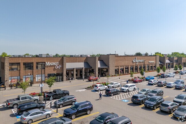
Property Record
3105 Niagara Falls Blvd, Buffalo, NY 14228

NEARBY LISTINGS FOR SALE OR LEASE
Property Detail
3105 Niagara Falls Blvd
142289-026-030-0002-004-100
15 & 41 12 7&8
Regionalshoppingcenterormallwithanchorstore
Erie
X
New York
36029C0363H
4.100
2025
38.33 AC
2024
North
009107
Buffalo/Niagara Falls
112,256 SF
Buffalo-Cheektowaga-Niagara Falls, NY
DEMOGRAPHICS near 3105 Niagara Falls Blvd
1 Mile
3 Mile
5 Mile
2024 Total Population
6,114
60,156
166,741
2029 Population
5,952
59,409
165,657
Pop Growth 2024-2029
(2.65%)
(1.24%)
(0.65%)
Average Age
38
42
42
2024 Total Households
2,388
26,940
69,798
HH Growth 2024-2029
(2.47%)
(1.11%)
(0.68%)
Median Household Inc
$72,382
$64,528
$70,246
Avg Household Size
2.50
2.20
2.20
2024 Avg HH Vehicles
2.00
2.00
2.00
Median Home Value
$247,587
$187,555
$188,347
Median Year Built
1973
1968
1962
Nearby Places
Map Layers
Map Styles
 Street
 Aerial
- Restaurants
- Banks
- Shops
- Fitness
- Groceries
PUBLIC TRANSPORTATION
AIRPORT
Niagara Falls International
DRIVE
WALK
Distance
Niagara Falls International
16 min
8.3 mi
Buffalo Niagara International
DRIVE
WALK
Distance
Buffalo Niagara International
20 min
10.5 mi
Freight Ports
Port of Toledo
DRIVE
WALK
Distance
Port of Toledo
375 min
315.1 mi
SALE & LEASE HISTORY
LISTING DATE
SALE/LEASE

Sep 13, 2017
For Lease
Aug 28, 2025
For Lease
Nearby Properties
Address
Land Use
TOTAL SIZE
Lot Size
Zoning
Address
Land Use
TOTAL SIZE
Lot Size
Zoning
5,472 SF
70.10 AC
Address
Land Use
TOTAL SIZE
Lot Size
Zoning
409,925 SF
36.41 AC
CTR-5
Address
Land Use
TOTAL SIZE
Lot Size
Zoning
283,706 SF
68.90 AC
Address
Land Use
TOTAL SIZE
Lot Size
Zoning
41,104 SF
27.52 AC
Address
Land Use
TOTAL SIZE
Lot Size
Zoning
16,065 SF
19.75 AC
Address
Land Use
TOTAL SIZE
Lot Size
Zoning
8,565 SF
22.65 AC
Address
Land Use
TOTAL SIZE
Lot Size
Zoning
12,262 SF
29 AC
MFR-5
Address
Land Use
TOTAL SIZE
Lot Size
Zoning
70,261 SF
14.63 AC
CTR-5
Address
Land Use
TOTAL SIZE
Lot Size
Zoning
213,943 SF
5.50 AC
Address
Land Use
TOTAL SIZE
Lot Size
Zoning
223,916 SF
8.25 AC
R-C
Address
Land Use
TOTAL SIZE
Lot Size
Zoning
8,842 SF
29.30 AC
Address
Land Use
TOTAL SIZE
Lot Size
Zoning
6,384 SF
13.40 AC
Address
Land Use
TOTAL SIZE
Lot Size
Zoning
11,248 SF
21.70 AC
MFR-5
Address
Land Use
TOTAL SIZE
Lot Size
Zoning
28,530 SF
30.20 AC
NCD
Address
Land Use
TOTAL SIZE
Lot Size
Zoning
173,303 SF
24.40 AC
R1-2
Address
Land Use
TOTAL SIZE
Lot Size
Zoning
2,135 SF
11.96 AC
Address
Land Use
TOTAL SIZE
Lot Size
Zoning
286,288 SF
50.90 AC
Address
Land Use
TOTAL SIZE
Lot Size
Zoning
113,316 SF
12.25 AC
CTR-5
Address
Land Use
TOTAL SIZE
Lot Size
Zoning
130,412 SF
21.21 AC
Address
Land Use
TOTAL SIZE
Lot Size
Zoning
96,554 SF
10.90 AC
Address
Land Use
TOTAL SIZE
Lot Size
Zoning
112,666 SF
3.39 AC
MFR-5
Address
Land Use
TOTAL SIZE
Lot Size
Zoning
128,867 SF
9.42 AC
RD
Address
Land Use
TOTAL SIZE
Lot Size
Zoning
270,320 SF
12.20 AC
Address
Land Use
TOTAL SIZE
Lot Size
Zoning
136,200 SF
4.10 AC
Address
Land Use
TOTAL SIZE
Lot Size
Zoning
137,878 SF
23.60 AC
R1-2
Address
Land Use
TOTAL SIZE
Lot Size
Zoning
81,920 SF
3.82 AC
Address
Land Use
TOTAL SIZE
Lot Size
Zoning
63,464 SF
2.44 AC
Address
Land Use
TOTAL SIZE
Lot Size
Zoning
40,288 SF
6.90 AC
00000
Address
Land Use
TOTAL SIZE
Lot Size
Zoning
22,204 SF
10.80 AC
CTR-8
The World's #1 Commercial Real Estate Marketplace
Connect with us
© 2026 CoStar Group
The information above has been obtained from sources believed reliable. While we do not doubt its accuracy we have not verified it and make no guarantee, warranty or representation about it. It is your responsibility to independently confirm its accuracy and completeness. Any projections, opinions, assumptions, or estimates used are for example only and do not represent the current or future performance of the property. The value of this transaction to you depends on tax and other factors which should be evaluated by your tax, financial, and legal advisors. You and your advisors should conduct a careful, independent investigation of the property to determine to your satisfaction the suitability of the property for your needs.