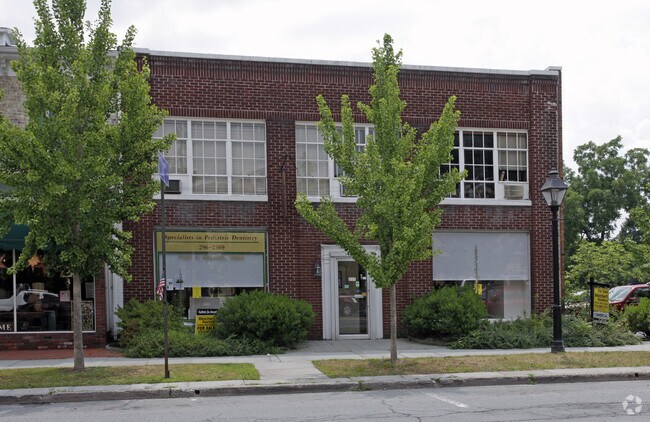
Property Record
315 Broad St, Milford, PA 18337

NEARBY LISTINGS FOR SALE OR LEASE
Property Detail
315 Broad St
Newark, NJ-PA
Broad Street
000528
LOT 340 STORE
Commercialnec
Pike
X
Pennsylvania
34037C0008E
340
2024
0.17 AC
2025
Pike County
950603
Northern New Jersey
10,296 SF
DEMOGRAPHICS near 315 Broad St
1 Mile
3 Mile
5 Mile
2024 Total Population
1,651
4,604
10,047
2029 Population
1,733
4,764
10,336
Pop Growth 2024-2029
+ 4.97%
+ 3.48%
+ 2.88%
Average Age
48
46
46
2024 Total Households
772
1,978
4,177
HH Growth 2024-2029
+ 5.05%
+ 3.49%
+ 2.85%
Median Household Inc
$64,737
$69,734
$82,700
Avg Household Size
2.10
2.20
2.30
2024 Avg HH Vehicles
2.00
2.00
2.00
Median Home Value
$295,160
$272,481
$266,137
Median Year Built
1973
1979
1983
Nearby Places
Map Layers
Map Styles
 Street
 Aerial
- Restaurants
- Banks
- Shops
- Fitness
- Groceries
PUBLIC TRANSPORTATION
COMMUTER RAIL
Port Jervis (Bergen County/Port Jervis Line - NJ Transit Commuter Rail (NJ Transit), Main/Port Jervis Line - NJ Transit Commuter Rail (NJ Transit))
DRIVE
WALK
Distance
Port Jervis (Bergen County/Port Jervis Line - NJ Transit Commuter Rail (NJ Transit), Main/Port Jervis Line - NJ Transit Commuter Rail (NJ Transit))
17 min
7.2 mi
Freight Ports
Maher Terminal
DRIVE
WALK
Distance
Maher Terminal
96 min
66.7 mi
SALE & LEASE HISTORY
LISTING DATE
SALE/LEASE

Sep 23, 2016
For Sale
Nov 07, 2017
For Lease
Mar 20, 2021
For Sale
Nearby Properties
Address
Land Use
TOTAL SIZE
Lot Size
Zoning
Address
Land Use
TOTAL SIZE
Lot Size
Zoning
Address
Land Use
TOTAL SIZE
Lot Size
Zoning
9 AC
C2
Address
Land Use
TOTAL SIZE
Lot Size
Zoning
12.40 AC
R-1
Address
Land Use
TOTAL SIZE
Lot Size
Zoning
3,884 SF
518.94 AC
CD
Address
Land Use
TOTAL SIZE
Lot Size
Zoning
17.20 AC
R-1
Address
Land Use
TOTAL SIZE
Lot Size
Zoning
513.27 AC
CD
Address
Land Use
TOTAL SIZE
Lot Size
Zoning
205.69 AC
CD
Address
Land Use
TOTAL SIZE
Lot Size
Zoning
5.07 AC
C-2
Address
Land Use
TOTAL SIZE
Lot Size
Zoning
6.47 AC
R-4
Address
Land Use
TOTAL SIZE
Lot Size
Zoning
5 AC
MC
Address
Land Use
TOTAL SIZE
Lot Size
Zoning
1.90 AC
206C
Address
Land Use
TOTAL SIZE
Lot Size
Zoning
11.87 AC
C-2
Address
Land Use
TOTAL SIZE
Lot Size
Zoning
189,132 SF
27.19 AC
Address
Land Use
TOTAL SIZE
Lot Size
Zoning
3.91 AC
C-2
Address
Land Use
TOTAL SIZE
Lot Size
Zoning
1,188 SF
8.12 AC
C-2
Address
Land Use
TOTAL SIZE
Lot Size
Zoning
6.50 AC
R-1
Address
Land Use
TOTAL SIZE
Lot Size
Zoning
37,089 SF
0.95 AC
Address
Land Use
TOTAL SIZE
Lot Size
Zoning
191.08 AC
CD
Address
Land Use
TOTAL SIZE
Lot Size
Zoning
1,864 SF
27.30 AC
R-1
Address
Land Use
TOTAL SIZE
Lot Size
Zoning
2.43 AC
C-2
Address
Land Use
TOTAL SIZE
Lot Size
Zoning
151.49 AC
CD
Address
Land Use
TOTAL SIZE
Lot Size
Zoning
1.03 AC
C-2
Address
Land Use
TOTAL SIZE
Lot Size
Zoning
1.81 AC
C-2
Address
Land Use
TOTAL SIZE
Lot Size
Zoning
Address
Land Use
TOTAL SIZE
Lot Size
Zoning
5.39 AC
C-2
Address
Land Use
TOTAL SIZE
Lot Size
Zoning
162.10 AC
CD
Address
Land Use
TOTAL SIZE
Lot Size
Zoning
4,160 SF
1 AC
R-4
Address
Land Use
TOTAL SIZE
Lot Size
Zoning
1.03 AC
C2
Address
Land Use
TOTAL SIZE
Lot Size
Zoning
5,040 SF
0.46 AC
C-2
Address
Land Use
TOTAL SIZE
Lot Size
Zoning
40.47 AC
C-2
The World's #1 Commercial Real Estate Marketplace
Connect with us
© 2025 CoStar Group
The information above has been obtained from sources believed reliable. While we do not doubt its accuracy we have not verified it and make no guarantee, warranty or representation about it. It is your responsibility to independently confirm its accuracy and completeness. Any projections, opinions, assumptions, or estimates used are for example only and do not represent the current or future performance of the property. The value of this transaction to you depends on tax and other factors which should be evaluated by your tax, financial, and legal advisors. You and your advisors should conduct a careful, independent investigation of the property to determine to your satisfaction the suitability of the property for your needs.