Property Record
312 N 4Th St, Lafayette, IN 47901
NEARBY LISTINGS FOR SALE OR LEASE
Property Detail
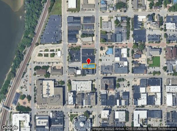
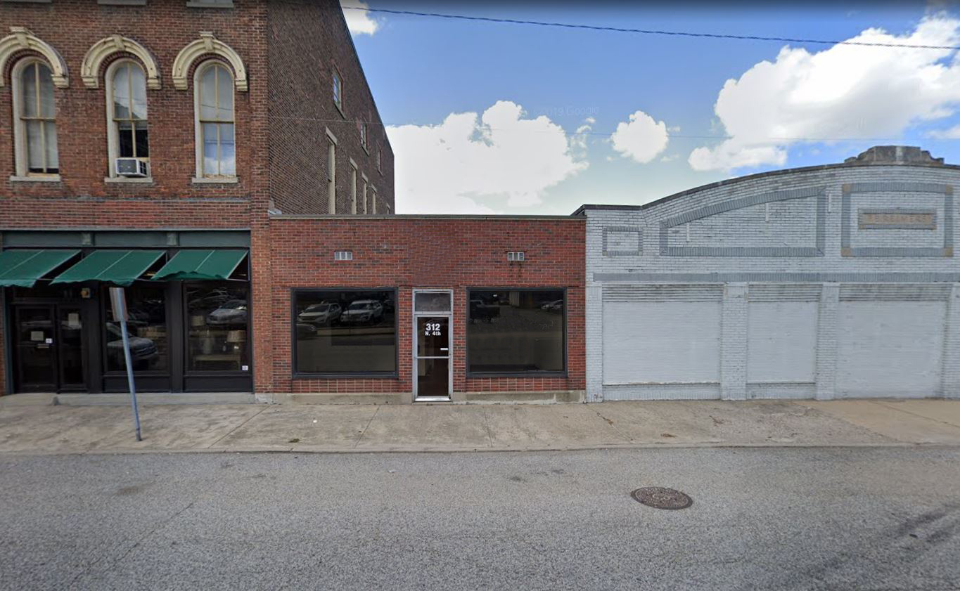
312 N 4Th St
Lafayette-West Lafayette, IN
Lafayette
79-07-20-452-003.000-004
ORIG PLAT 46 FT S SIDE LOT 75
Officebuilding
Tippecanoe
X
Indiana
18157C0142D
75
2023
0.14 AC
2024
Downtown Lafayette
011100
Other Market Areas
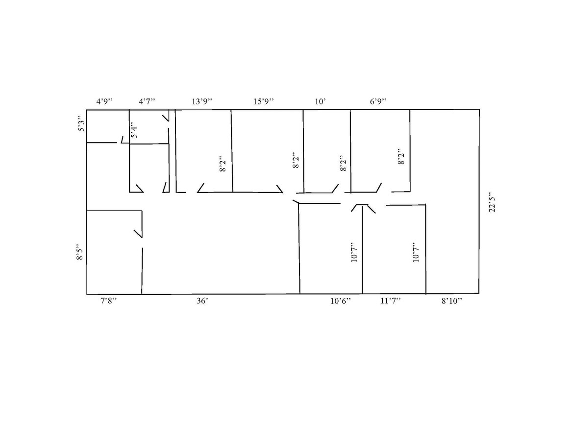
6,404 SF
DEMOGRAPHICS near 312 N 4Th St
1 Mile
3 Mile
5 Mile
2024 Total Population
22,837
84,575
147,624
2029 Population
23,756
87,424
152,285
Pop Growth 2024-2029
+ 4.02%
+ 3.37%
+ 3.16%
Average Age
30
33
35
2024 Total Households
10,799
34,161
59,842
HH Growth 2024-2029
+ 4.17%
+ 3.83%
+ 3.47%
Median Household Inc
$27,207
$39,589
$48,279
Avg Household Size
1.90
2.10
2.20
2024 Avg HH Vehicles
1.00
2.00
2.00
Median Home Value
$158,490
$153,388
$180,645
Median Year Built
1977
1970
1984
Nearby Places
- Restaurants
- Banks
- Shops
- Fitness
- Groceries
PUBLIC TRANSPORTATION
COMMUTER RAIL
Lafayette Amtrak Station (Cardinal - Amtrak)
DRIVE
WALK
Distance
Lafayette Amtrak Station (Cardinal - Amtrak)
1 min
3 min
0.2 mi
Freight Ports
Port Milwaukee
DRIVE
WALK
Distance
Port Milwaukee
250 min
207.4 mi
SALE & LEASE HISTORY
LISTING DATE
SALE/LEASE

Sep 24, 2016
For Sale
Nov 08, 2017
For Lease
Jan 24, 2023
For Lease
Aug 09, 2018
For Lease
Nearby Properties
Address
Land Use
TOTAL SIZE
Lot Size
Zoning
Address
Land Use
TOTAL SIZE
Lot Size
Zoning
469,872 SF
0.85 AC
Address
Land Use
TOTAL SIZE
Lot Size
Zoning
377,937 SF
44 SF
Address
Land Use
TOTAL SIZE
Lot Size
Zoning
385,162 SF
0.45 AC
Address
Land Use
TOTAL SIZE
Lot Size
Zoning
401,345 SF
1.64 AC
Address
Land Use
TOTAL SIZE
Lot Size
Zoning
498,665 SF
1.94 AC
Address
Land Use
TOTAL SIZE
Lot Size
Zoning
Address
Land Use
TOTAL SIZE
Lot Size
Zoning
417,720 SF
3.09 AC
Address
Land Use
TOTAL SIZE
Lot Size
Zoning
Address
Land Use
TOTAL SIZE
Lot Size
Zoning
249,214 SF
1.93 AC
Address
Land Use
TOTAL SIZE
Lot Size
Zoning
265,805 SF
44 SF
Address
Land Use
TOTAL SIZE
Lot Size
Zoning
402,757 SF
87 SF
Address
Land Use
TOTAL SIZE
Lot Size
Zoning
159,723 SF
44 SF
Address
Land Use
TOTAL SIZE
Lot Size
Zoning
148,860 SF
1.25 AC
Address
Land Use
TOTAL SIZE
Lot Size
Zoning
210,829 SF
87 SF
Address
Land Use
TOTAL SIZE
Lot Size
Zoning
0.01 AC
Address
Land Use
TOTAL SIZE
Lot Size
Zoning
Address
Land Use
TOTAL SIZE
Lot Size
Zoning
232,565 SF
1.15 AC
Address
Land Use
TOTAL SIZE
Lot Size
Zoning
Address
Land Use
TOTAL SIZE
Lot Size
Zoning
1,449,360 SF
0.01 AC
Address
Land Use
TOTAL SIZE
Lot Size
Zoning
205,701 SF
1.27 AC
Address
Land Use
TOTAL SIZE
Lot Size
Zoning
77,226 SF
0.01 AC
Address
Land Use
TOTAL SIZE
Lot Size
Zoning
27,300 SF
22.52 AC
Address
Land Use
TOTAL SIZE
Lot Size
Zoning
164,234 SF
0.88 AC
Address
Land Use
TOTAL SIZE
Lot Size
Zoning
184,441 SF
44 SF
Address
Land Use
TOTAL SIZE
Lot Size
Zoning
222,276 SF
0.31 AC
Address
Land Use
TOTAL SIZE
Lot Size
Zoning
113,044 SF
44 SF
Address
Land Use
TOTAL SIZE
Lot Size
Zoning
42,800 SF
131 SF
Address
Land Use
TOTAL SIZE
Lot Size
Zoning
141,960 SF
2.27 AC
Address
Land Use
TOTAL SIZE
Lot Size
Zoning
118,066 SF
0.80 AC
Address
Land Use
TOTAL SIZE
Lot Size
Zoning
135,090 SF
0.80 AC
The World's #1 Commercial Real Estate Marketplace
Connect with us
© 2025 CoStar Group
The information above has been obtained from sources believed reliable. While we do not doubt its accuracy we have not verified it and make no guarantee, warranty or representation about it. It is your responsibility to independently confirm its accuracy and completeness. Any projections, opinions, assumptions, or estimates used are for example only and do not represent the current or future performance of the property. The value of this transaction to you depends on tax and other factors which should be evaluated by your tax, financial, and legal advisors. You and your advisors should conduct a careful, independent investigation of the property to determine to your satisfaction the suitability of the property for your needs.