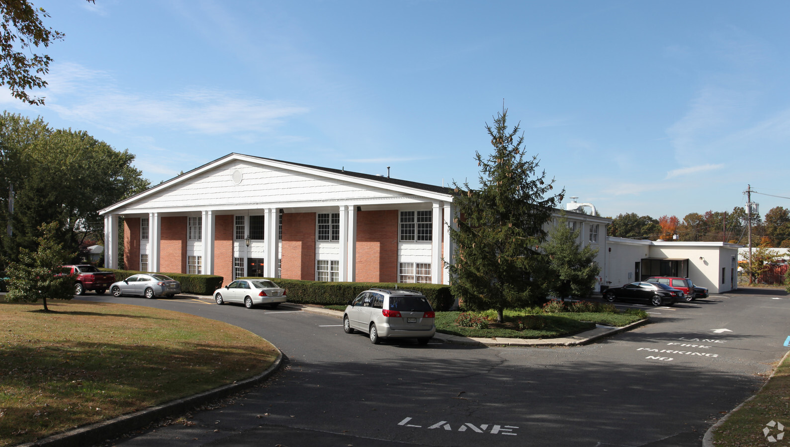
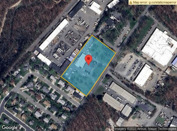
Property Record
3145 Bordentown Ave, Parlin, NJ 08859

Current Lease Availabilities
NEARBY LISTINGS FOR SALE OR LEASE
Property Detail
3145 Bordentown Ave
New York-Jersey City-White Plains, NY-NJ
3.93 ACS
19-00029-04-00002
Middlesex
Vacantlandnec
New Jersey
X
2
34023C0154F
3.93 AC
2023
Perth Amboy/GSP
2024
Northern New Jersey
007103
DEMOGRAPHICS near 3145 Bordentown Ave
1 Mile
3 Mile
5 Mile
2024 Total Population
4,869
71,193
188,168
2029 Population
4,822
70,748
186,694
Pop Growth 2024-2029
(0.97%)
(0.63%)
(0.78%)
Average Age
42
41
41
2024 Total Households
1,689
26,791
68,983
HH Growth 2024-2029
(1.12%)
(0.71%)
(0.80%)
Median Household Inc
$115,483
$91,330
$93,668
Avg Household Size
2.80
2.60
2.70
2024 Avg HH Vehicles
2.00
2.00
2.00
Median Home Value
$343,964
$377,459
$382,344
Median Year Built
1958
1970
1968
Nearby Places
- Restaurants
- Banks
- Shops
- Fitness
- Groceries
PUBLIC TRANSPORTATION
COMMUTER RAIL
South Amboy (North Jersey Coast Line - NJ Transit Commuter Rail (NJ Transit))
DRIVE
WALK
Distance
South Amboy (North Jersey Coast Line - NJ Transit Commuter Rail (NJ Transit))
9 min
3.5 mi
Perth Amboy (North Jersey Coast Line - NJ Transit Commuter Rail (NJ Transit))
DRIVE
WALK
Distance
Perth Amboy (North Jersey Coast Line - NJ Transit Commuter Rail (NJ Transit))
12 min
6.5 mi
AIRPORT
Newark Liberty International
DRIVE
WALK
Distance
Newark Liberty International
35 min
27.2 mi
Trenton Mercer
DRIVE
WALK
Distance
Trenton Mercer
56 min
34.7 mi
Freight Ports
New York Container Terminal
DRIVE
WALK
Distance
New York Container Terminal
29 min
19.4 mi
Nearby Properties
Address
Land Use
TOTAL SIZE
Lot Size
Zoning
Address
Land Use
TOTAL SIZE
Lot Size
Zoning
176.53 AC
G1
Address
Land Use
TOTAL SIZE
Lot Size
Zoning
Address
Land Use
TOTAL SIZE
Lot Size
Zoning
2.14 AC
C-4
Address
Land Use
TOTAL SIZE
Lot Size
Zoning
Address
Land Use
TOTAL SIZE
Lot Size
Zoning
726 SF
75.46 AC
P
Address
Land Use
TOTAL SIZE
Lot Size
Zoning
7,904 SF
60 AC
AF
Address
Land Use
TOTAL SIZE
Lot Size
Zoning
Address
Land Use
TOTAL SIZE
Lot Size
Zoning
31.22 AC
G1
Address
Land Use
TOTAL SIZE
Lot Size
Zoning
Address
Land Use
TOTAL SIZE
Lot Size
Zoning
3.29 AC
M1
Address
Land Use
TOTAL SIZE
Lot Size
Zoning
7,904 SF
38.30 AC
AF
Address
Land Use
TOTAL SIZE
Lot Size
Zoning
7,905 SF
26.55 AC
CC
Address
Land Use
TOTAL SIZE
Lot Size
Zoning
Address
Land Use
TOTAL SIZE
Lot Size
Zoning
169.71 AC
I
Address
Land Use
TOTAL SIZE
Lot Size
Zoning
7,904 SF
30 AC
AF
Address
Land Use
TOTAL SIZE
Lot Size
Zoning
1.27 AC
Address
Land Use
TOTAL SIZE
Lot Size
Zoning
7,905 SF
22.82 AC
CC
Address
Land Use
TOTAL SIZE
Lot Size
Zoning
14.34 AC
R100
Address
Land Use
TOTAL SIZE
Lot Size
Zoning
7,801 SF
39.88 AC
AF
Address
Land Use
TOTAL SIZE
Lot Size
Zoning
7,801 SF
33.28 AC
AF
Address
Land Use
TOTAL SIZE
Lot Size
Zoning
7,904 SF
14.66 AC
R15
Address
Land Use
TOTAL SIZE
Lot Size
Zoning
19.97 AC
P
Address
Land Use
TOTAL SIZE
Lot Size
Zoning
7,904 SF
69.62 AC
AF
Address
Land Use
TOTAL SIZE
Lot Size
Zoning
95.75 AC
I
Address
Land Use
TOTAL SIZE
Lot Size
Zoning
0.24 AC
C-4
Address
Land Use
TOTAL SIZE
Lot Size
Zoning
775 SF
26.95 AC
RAWDI
Address
Land Use
TOTAL SIZE
Lot Size
Zoning
3,850 SF
22.94 AC
G1
Address
Land Use
TOTAL SIZE
Lot Size
Zoning
47.57 AC
SED
Address
Land Use
TOTAL SIZE
Lot Size
Zoning
18.19 AC
G1
Address
Land Use
TOTAL SIZE
Lot Size
Zoning
19.11 AC
B2PUD
The World's #1 Commercial Real Estate Marketplace
Connect with us
© 2025 CoStar Group
The information above has been obtained from sources believed reliable. While we do not doubt its accuracy we have not verified it and make no guarantee, warranty or representation about it. It is your responsibility to independently confirm its accuracy and completeness. Any projections, opinions, assumptions, or estimates used are for example only and do not represent the current or future performance of the property. The value of this transaction to you depends on tax and other factors which should be evaluated by your tax, financial, and legal advisors. You and your advisors should conduct a careful, independent investigation of the property to determine to your satisfaction the suitability of the property for your needs.